Willow Park Reservoir Topo Map Wyoming
To zoom in, hover over the map of Willow Park Reservoir
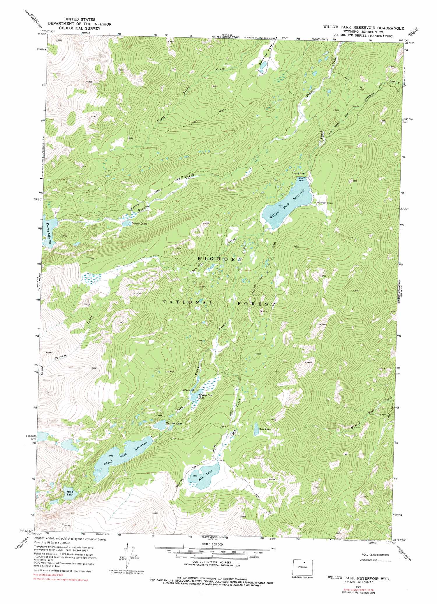
USGS Topo Quad 44107d1 - 1:24,000 scale
| Topo Map Name: | Willow Park Reservoir |
| USGS Topo Quad ID: | 44107d1 |
| Print Size: | ca. 21 1/4" wide x 27" high |
| Southeast Coordinates: | 44.375° N latitude / 107° W longitude |
| Map Center Coordinates: | 44.4375° N latitude / 107.0625° W longitude |
| U.S. State: | WY |
| Filename: | o44107d1.jpg |
| Download Map JPG Image: | Willow Park Reservoir topo map 1:24,000 scale |
| Map Type: | Topographic |
| Topo Series: | 7.5´ |
| Map Scale: | 1:24,000 |
| Source of Map Images: | United States Geological Survey (USGS) |
| Alternate Map Versions: |
Willow Park Reservoir WY 1967, updated 1971 Download PDF Buy paper map Willow Park Reservoir WY 1967, updated 1977 Download PDF Buy paper map Willow Park Reservoir WY 1993, updated 1997 Download PDF Buy paper map Willow Park Reservoir WY 2012 Download PDF Buy paper map Willow Park Reservoir WY 2015 Download PDF Buy paper map |
| FStopo: | US Forest Service topo Willow Park Reservoir is available: Download FStopo PDF Download FStopo TIF |
1:24,000 Topo Quads surrounding Willow Park Reservoir
Walker Mountain |
Beckton |
Beaver Creek Hills |
Big Horn |
Buffalo Run Creek |
Dome Lake |
Park Reservoir |
Little Goose Peak |
Story |
Banner |
Shell Lake |
Cloud Peak |
Willow Park Reservoir |
Stone Mountain |
Lake De Smet West |
Lake Solitude |
Lake Helen |
Lake Angeline |
Hunter Mesa |
North Ridge |
Brokenback Narrows |
Meadowlark Lake |
Powder River Pass |
Caribou Creek |
Klondike Ranch |
> Back to 44107a1 at 1:100,000 scale
> Back to 44106a1 at 1:250,000 scale
> Back to U.S. Topo Maps home
Willow Park Reservoir topo map: Gazetteer
Willow Park Reservoir: Canals
Rock Creek and Piney Diversion Ditch elevation 2526m 8287′Willow Park Reservoir: Dams
Cloud Peak Dam elevation 3017m 9898′Kearney Lake Dam elevation 2799m 9183′
Willow Park Dam elevation 2654m 8707′
Willow Park Reservoir: Lakes
Beaver Lakes elevation 2694m 8838′Elk Lake elevation 3007m 9865′
Flatiron Lake elevation 2910m 9547′
Frying Pan Lake elevation 2860m 9383′
Gem Lake elevation 3019m 9904′
Lake Mead elevation 3009m 9872′
Willow Park Reservoir: Reservoirs
Cloud Peak Reservoir elevation 2964m 9724′Kearney Lake elevation 2799m 9183′
Kearny Lake Reservoir elevation 2794m 9166′
Willow Park Reservoir elevation 2654m 8707′
Willow Park Reservoir elevation 2627m 8618′
Willow Park Reservoir: Streams
Elk Creek elevation 2803m 9196′Kearny Creek elevation 2473m 8113′
Kearny Creek elevation 2477m 8126′
Penrose Creek elevation 2633m 8638′
Willow Park Reservoir: Trails
Solitude Trail elevation 3247m 10652′Willow Park Reservoir digital topo map on disk
Buy this Willow Park Reservoir topo map showing relief, roads, GPS coordinates and other geographical features, as a high-resolution digital map file on DVD:
Eastern Wyoming & Western South Dakota
Buy digital topo maps: Eastern Wyoming & Western South Dakota