Shell Topo Map Wyoming
To zoom in, hover over the map of Shell
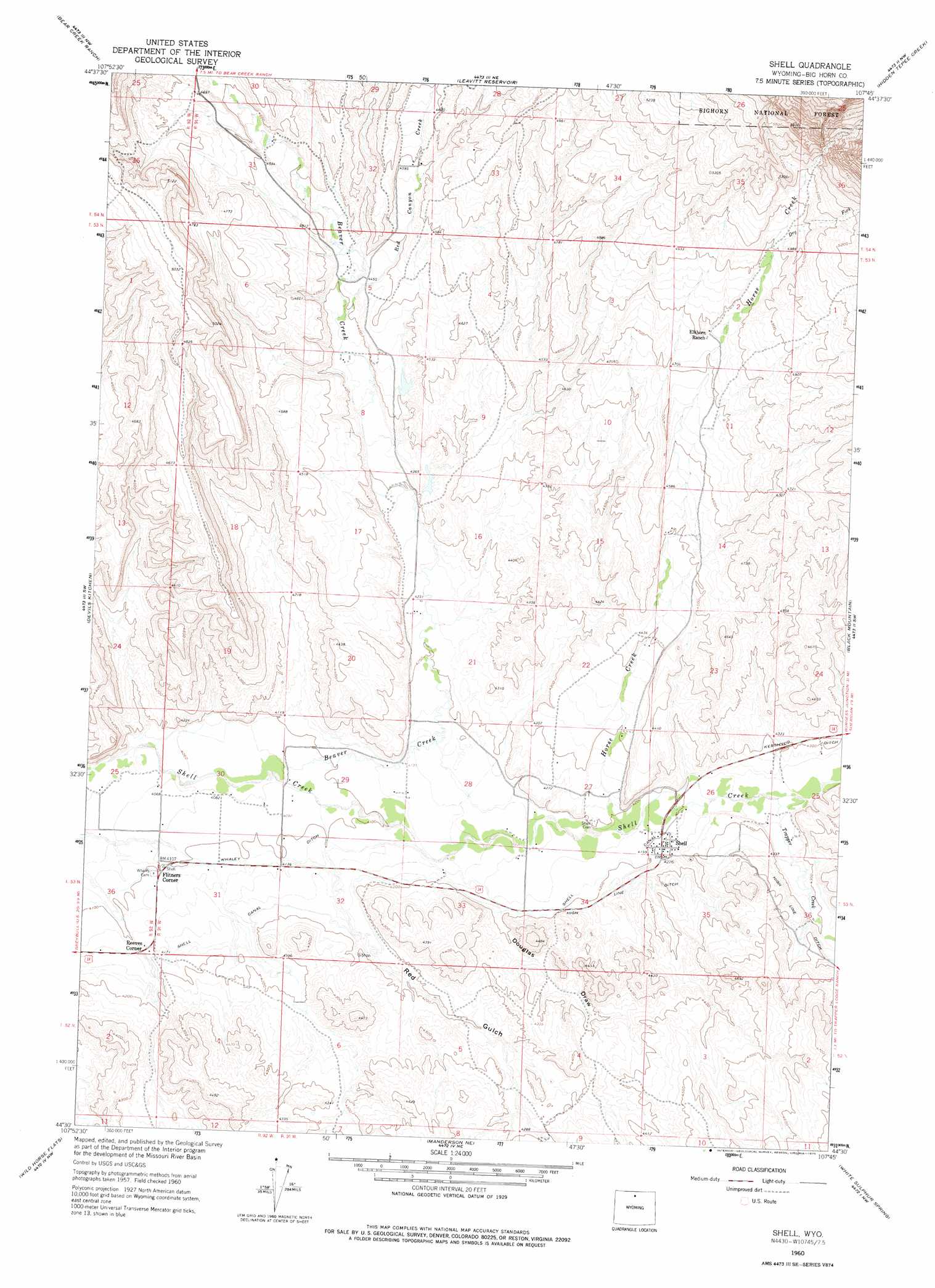
USGS Topo Quad 44107e7 - 1:24,000 scale
| Topo Map Name: | Shell |
| USGS Topo Quad ID: | 44107e7 |
| Print Size: | ca. 21 1/4" wide x 27" high |
| Southeast Coordinates: | 44.5° N latitude / 107.75° W longitude |
| Map Center Coordinates: | 44.5625° N latitude / 107.8125° W longitude |
| U.S. State: | WY |
| Filename: | o44107e7.jpg |
| Download Map JPG Image: | Shell topo map 1:24,000 scale |
| Map Type: | Topographic |
| Topo Series: | 7.5´ |
| Map Scale: | 1:24,000 |
| Source of Map Images: | United States Geological Survey (USGS) |
| Alternate Map Versions: |
Shell WY 1960, updated 1962 Download PDF Buy paper map Shell WY 1960, updated 1975 Download PDF Buy paper map Shell WY 1993, updated 1997 Download PDF Buy paper map Shell WY 2012 Download PDF Buy paper map Shell WY 2015 Download PDF Buy paper map |
| FStopo: | US Forest Service topo Shell is available: Download FStopo PDF Download FStopo TIF |
1:24,000 Topo Quads surrounding Shell
Cottonwood Canyon |
Medicine Wheel |
Bald Mountain |
Ice Creek |
Burgess Junction |
Alkali Creek |
Bear Creek Ranch |
Leavitt Reservoir |
Hidden Tepee Creek |
Granite Pass |
Greybull North |
Devils Kitchen |
Shell |
Black Mountain |
Shell Falls |
Greybull South |
Wild Horse Flats |
Manderson Ne |
White Sulphur Spring |
Bush Butte |
Orchard Bench |
Manderson |
Manderson Se |
Flitner Reservoir |
Hyatt Ranch |
> Back to 44107e1 at 1:100,000 scale
> Back to 44106a1 at 1:250,000 scale
> Back to U.S. Topo Maps home
Shell topo map: Gazetteer
Shell: Canals
High Line Ditch elevation 1328m 4356′Shell: Dams
Ewen Dam elevation 1314m 4311′Ewen Pence Gulch Dam elevation 1345m 4412′
Shell: Mines
Big Hill Group Mine elevation 1297m 4255′Big Hill Group Mine elevation 1300m 4265′
Big Hill Group Mine elevation 1326m 4350′
Big Hill Group Mine elevation 1311m 4301′
Big Hill Group Mine elevation 1285m 4215′
Porter Gulch Area Mine elevation 1468m 4816′
Shell: Populated Places
Flitners Corner elevation 1251m 4104′Reeves Corner elevation 1268m 4160′
Shell elevation 1286m 4219′
Shell: Reservoirs
Ewen Pence Gulch Reservoir elevation 1345m 4412′Ewen Reservoir elevation 1314m 4311′
Shell: Streams
Beaver Creek elevation 1242m 4074′Dry Fork Horse Creek elevation 1487m 4878′
Horse Creek elevation 1273m 4176′
Red Canyon Creek elevation 1335m 4379′
Trapper Creek elevation 1290m 4232′
Shell: Valleys
Douglas Draw elevation 1277m 4189′Red Gulch elevation 1262m 4140′
Shell digital topo map on disk
Buy this Shell topo map showing relief, roads, GPS coordinates and other geographical features, as a high-resolution digital map file on DVD:
Eastern Wyoming & Western South Dakota
Buy digital topo maps: Eastern Wyoming & Western South Dakota