Bear Creek Ranch Topo Map Wyoming
To zoom in, hover over the map of Bear Creek Ranch
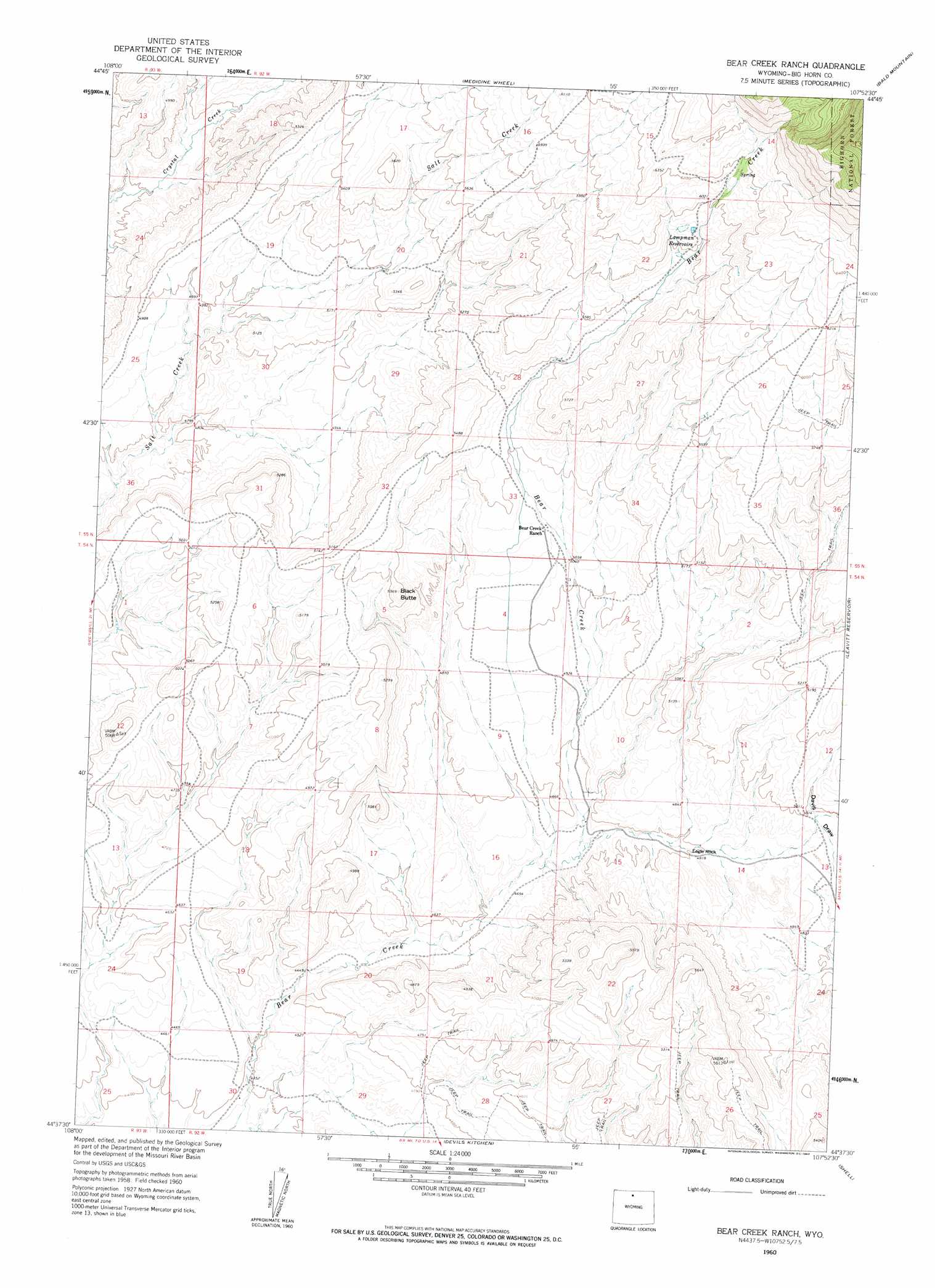
USGS Topo Quad 44107f8 - 1:24,000 scale
| Topo Map Name: | Bear Creek Ranch |
| USGS Topo Quad ID: | 44107f8 |
| Print Size: | ca. 21 1/4" wide x 27" high |
| Southeast Coordinates: | 44.625° N latitude / 107.875° W longitude |
| Map Center Coordinates: | 44.6875° N latitude / 107.9375° W longitude |
| U.S. State: | WY |
| Filename: | o44107f8.jpg |
| Download Map JPG Image: | Bear Creek Ranch topo map 1:24,000 scale |
| Map Type: | Topographic |
| Topo Series: | 7.5´ |
| Map Scale: | 1:24,000 |
| Source of Map Images: | United States Geological Survey (USGS) |
| Alternate Map Versions: |
Bear Creek Ranch WY 1960, updated 1962 Download PDF Buy paper map Bear Creek Ranch WY 1960, updated 1962 Download PDF Buy paper map Bear Creek Ranch WY 1993, updated 1997 Download PDF Buy paper map Bear Creek Ranch WY 2012 Download PDF Buy paper map Bear Creek Ranch WY 2015 Download PDF Buy paper map |
| FStopo: | US Forest Service topo Bear Creek Ranch is available: Download FStopo PDF Download FStopo TIF |
1:24,000 Topo Quads surrounding Bear Creek Ranch
Natural Trap Cave |
Simmons Canyon |
Mexican Hill |
Boyd Ridge |
Bull Elk Park |
Kane |
Cottonwood Canyon |
Medicine Wheel |
Bald Mountain |
Ice Creek |
Spence |
Alkali Creek |
Bear Creek Ranch |
Leavitt Reservoir |
Hidden Tepee Creek |
Sheep Canyon |
Greybull North |
Devils Kitchen |
Shell |
Black Mountain |
Gould Butte |
Greybull South |
Wild Horse Flats |
Manderson Ne |
White Sulphur Spring |
> Back to 44107e1 at 1:100,000 scale
> Back to 44106a1 at 1:250,000 scale
> Back to U.S. Topo Maps home
Bear Creek Ranch topo map: Gazetteer
Bear Creek Ranch: Dams
Flockhart Dam elevation 1725m 5659′Bear Creek Ranch: Mines
End of Day Mine elevation 1474m 4835′Sun Up Claim elevation 1475m 4839′
Bear Creek Ranch: Pillars
Eagle Rock elevation 1468m 4816′Bear Creek Ranch: Reservoirs
Flockhart Reservoir elevation 1725m 5659′Lampman Reservoir elevation 1797m 5895′
Bear Creek Ranch: Summits
Black Butte elevation 1638m 5374′Bear Creek Ranch digital topo map on disk
Buy this Bear Creek Ranch topo map showing relief, roads, GPS coordinates and other geographical features, as a high-resolution digital map file on DVD:
Eastern Wyoming & Western South Dakota
Buy digital topo maps: Eastern Wyoming & Western South Dakota