Spence Topo Map Wyoming
To zoom in, hover over the map of Spence
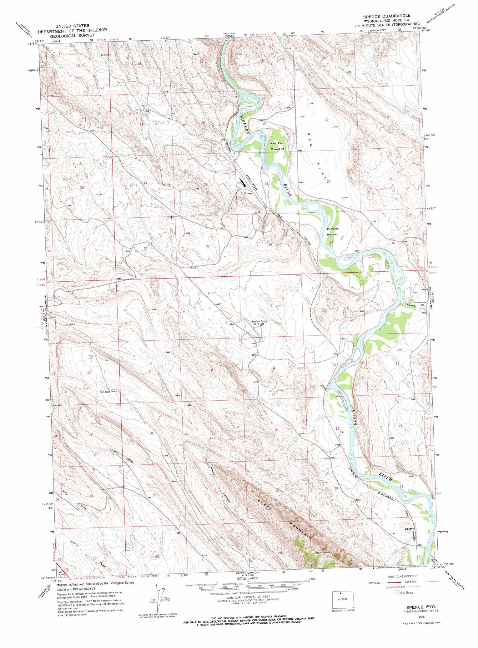
USGS Topo Quad 44108f2 - 1:24,000 scale
| Topo Map Name: | Spence |
| USGS Topo Quad ID: | 44108f2 |
| Print Size: | ca. 21 1/4" wide x 27" high |
| Southeast Coordinates: | 44.625° N latitude / 108.125° W longitude |
| Map Center Coordinates: | 44.6875° N latitude / 108.1875° W longitude |
| U.S. State: | WY |
| Filename: | o44108f2.jpg |
| Download Map JPG Image: | Spence topo map 1:24,000 scale |
| Map Type: | Topographic |
| Topo Series: | 7.5´ |
| Map Scale: | 1:24,000 |
| Source of Map Images: | United States Geological Survey (USGS) |
| Alternate Map Versions: |
Spence WY 1966, updated 1970 Download PDF Buy paper map Spence WY 2012 Download PDF Buy paper map Spence WY 2015 Download PDF Buy paper map |
1:24,000 Topo Quads surrounding Spence
Cowley |
Sykes Spring |
Natural Trap Cave |
Simmons Canyon |
Mexican Hill |
Lovell |
Lovell Lakes |
Kane |
Cottonwood Canyon |
Medicine Wheel |
Jack Horner Reservoir |
North Emblem Reservoir |
Spence |
Alkali Creek |
Bear Creek Ranch |
Emblem |
Emblem Se |
Sheep Canyon |
Greybull North |
Devils Kitchen |
Burlington |
Otto |
Gould Butte |
Greybull South |
Wild Horse Flats |
> Back to 44108e1 at 1:100,000 scale
> Back to 44108a1 at 1:250,000 scale
> Back to U.S. Topo Maps home
Spence topo map: Gazetteer
Spence: Bends
Perkins Bottom elevation 1127m 3697′Spence: Flats
Red Flat elevation 1142m 3746′Red Rim Meadows elevation 1126m 3694′
Spence: Mines
Al Egbert Mine elevation 1216m 3989′Asay-Egbert Prospects Mine elevation 1216m 3989′
Dry Creek Group Number One Mine elevation 1216m 3989′
Dry Creek Group Number Three Mine elevation 1242m 4074′
Little Sheep Mountain Anticline Number Eight Mine elevation 1142m 3746′
Little Sheep Mountain Anticline Number Five Mine elevation 1185m 3887′
Little Sheep Mountain Anticline Number Four Mine elevation 1183m 3881′
Little Sheep Mountain Anticline Number Nine Mine elevation 1269m 4163′
Little Sheep Mountain Anticline Number Seven Mine elevation 1188m 3897′
Little Sheep Mountain Anticline Number Six Mine elevation 1129m 3704′
Little Sheep Mountain Anticline Number Ten Mine elevation 1208m 3963′
Little Sheep Mountain Anticline Number Three elevation 1255m 4117′
Little Sheep Mountain Anticline Number Two Mine elevation 1204m 3950′
Lovell Mine elevation 1130m 3707′
Marvel Mine elevation 1216m 3989′
North Emblem Mine elevation 1152m 3779′
Spence: Oilfields
Spence Dome Oil Field elevation 1186m 3891′Spence: Reservoirs
Bethurem Reservoir elevation 1172m 3845′Phelps Reservoir Number 1 elevation 1130m 3707′
Phelps Reservoir Number 2 elevation 1129m 3704′
Spence: Springs
Little Sheep Mountain Spring elevation 1118m 3667′Spence: Streams
Alkali Creek elevation 1160m 3805′Crystal Creek elevation 1129m 3704′
Spence: Valleys
Black Gulch elevation 1251m 4104′Ribbon Canyon elevation 1254m 4114′
Spence digital topo map on disk
Buy this Spence topo map showing relief, roads, GPS coordinates and other geographical features, as a high-resolution digital map file on DVD: