Vocation Topo Map Wyoming
To zoom in, hover over the map of Vocation
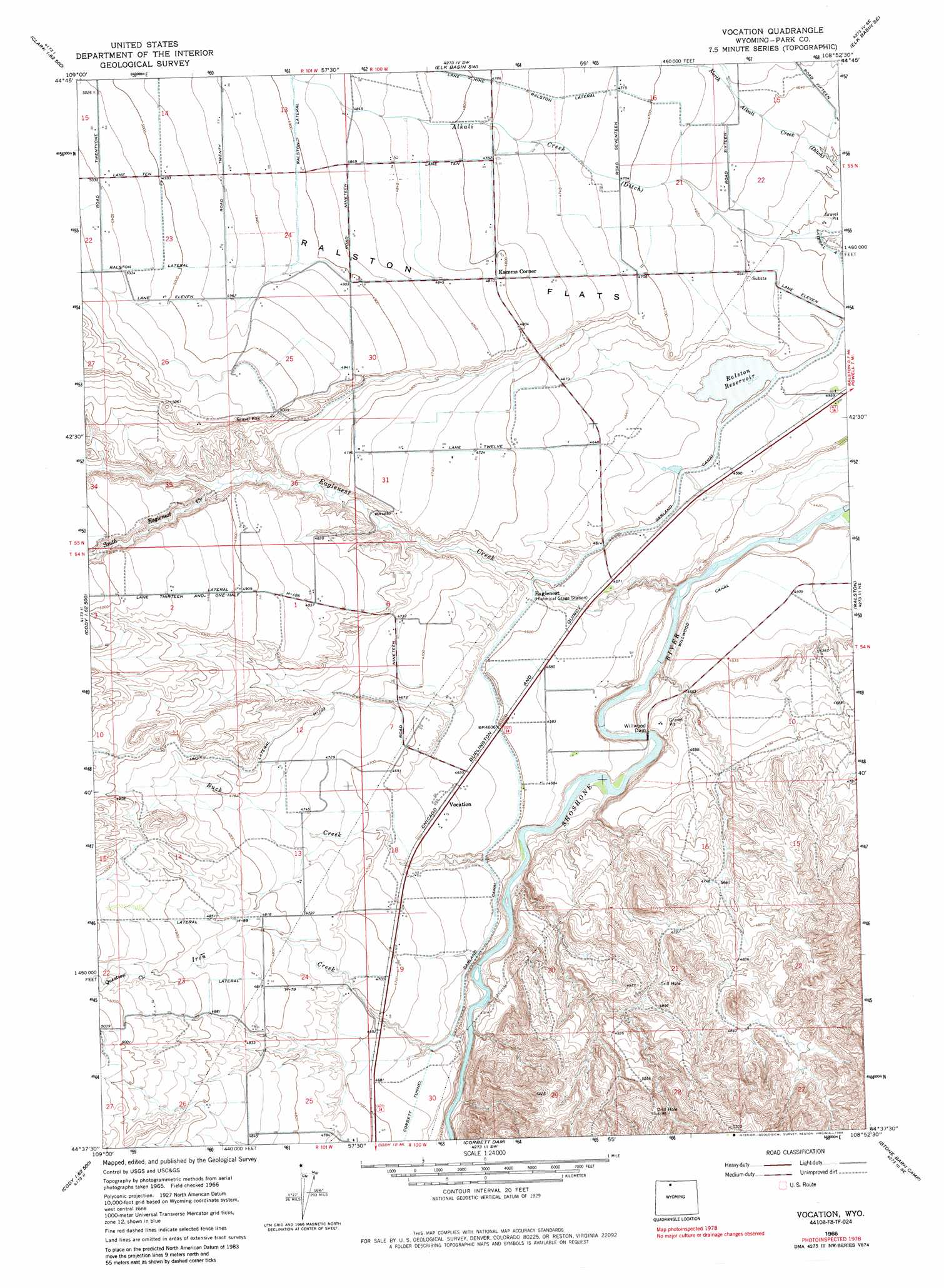
USGS Topo Quad 44108f8 - 1:24,000 scale
| Topo Map Name: | Vocation |
| USGS Topo Quad ID: | 44108f8 |
| Print Size: | ca. 21 1/4" wide x 27" high |
| Southeast Coordinates: | 44.625° N latitude / 108.875° W longitude |
| Map Center Coordinates: | 44.6875° N latitude / 108.9375° W longitude |
| U.S. State: | WY |
| Filename: | o44108f8.jpg |
| Download Map JPG Image: | Vocation topo map 1:24,000 scale |
| Map Type: | Topographic |
| Topo Series: | 7.5´ |
| Map Scale: | 1:24,000 |
| Source of Map Images: | United States Geological Survey (USGS) |
| Alternate Map Versions: |
Vocation WY 1966, updated 1970 Download PDF Buy paper map Vocation WY 1966, updated 1984 Download PDF Buy paper map Vocation WY 2012 Download PDF Buy paper map Vocation WY 2015 Download PDF Buy paper map |
1:24,000 Topo Quads surrounding Vocation
Clark |
Badger Basin |
Elk Basin Nw |
Elk Basin |
Deaver Reservoir |
Chapman Bench |
Badlands Hills |
Elk Basin Sw |
Elk Basin Se |
Garland |
Goff Lake |
Eaglenest Basin |
Vocation |
Ralston |
Gilmore Hill Nw |
Shoshone Canyon |
Cody |
Corbett Dam |
Stone Barn Camp |
Gilmore Hill |
Irma Flats |
Indian Pass |
Oregon Basin |
Eagle Pass |
Y U Bench Nw |
> Back to 44108e1 at 1:100,000 scale
> Back to 44108a1 at 1:250,000 scale
> Back to U.S. Topo Maps home
Vocation topo map: Gazetteer
Vocation: Canals
Garland Canal elevation 1401m 4596′Lateral H-103 elevation 1465m 4806′
Lateral H-105 elevation 1494m 4901′
Lateral H-79 elevation 1469m 4819′
Lateral H-89 elevation 1482m 4862′
Ralston Lateral elevation 1446m 4744′
Vocation: Dams
Emma Lanchbury Dam elevation 1418m 4652′Willwood Diversion Dam elevation 1404m 4606′
Vocation: Populated Places
Kamms Corner elevation 1467m 4812′Vocation elevation 1418m 4652′
Vocation: Reservoirs
Emma Lanchbury Reservoir elevation 1418m 4652′Ralston Reservoir elevation 1401m 4596′
Vocation: Streams
Buck Creek elevation 1378m 4520′Eaglenest Creek elevation 1354m 4442′
Iron Creek elevation 1408m 4619′
Question Creek elevation 1494m 4901′
South Eaglenest Creek elevation 1460m 4790′
Vocation digital topo map on disk
Buy this Vocation topo map showing relief, roads, GPS coordinates and other geographical features, as a high-resolution digital map file on DVD: