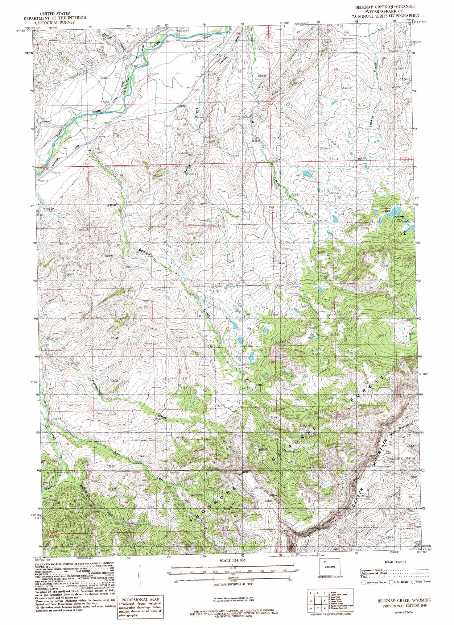
Belknap Creek Topo Map Wyoming
To zoom in, hover over the map of Belknap Creek
USGS Topo Quad 44109c3 - 1:24,000 scale
| Topo Map Name: | Belknap Creek |
| USGS Topo Quad ID: | 44109c3 |
| Print Size: | ca. 21 1/4" wide x 27" high |
| Southeast Coordinates: | 44.25° N latitude / 109.25° W longitude |
| Map Center Coordinates: | 44.3125° N latitude / 109.3125° W longitude |
| U.S. State: | WY |
| Filename: | o44109c3.jpg |
| Download Map JPG Image: | Belknap Creek topo map 1:24,000 scale |
| Map Type: | Topographic |
| Topo Series: | 7.5´ |
| Map Scale: | 1:24,000 |
| Source of Map Images: | United States Geological Survey (USGS) |
| Alternate Map Versions: |
Belknap Creek WY 1988, updated 1988 Download PDF Buy paper map Belknap Creek WY 1991, updated 1997 Download PDF Buy paper map Belknap Creek WY 2012 Download PDF Buy paper map Belknap Creek WY 2015 Download PDF Buy paper map |
| FStopo: | US Forest Service topo Belknap Creek is available: Download FStopo PDF Download FStopo TIF |
1:24,000 Topo Quads surrounding Belknap Creek
Dead Indian Peak |
Jim Mountain |
Logan Mountain |
Shoshone Canyon |
Cody |
Flag Peak |
Wapiti |
Castle Rock Creek |
Irma Flats |
Indian Pass |
Ptarmigan Mountain |
Twin Creek |
Belknap Creek |
Devils Tooth |
Horner Creek |
Valley |
Aldrich Basin |
North Fork Pickett Creek |
Thomas Reservoir |
Tonopah Ridge |
Needle Mountain |
Irish Rock |
Phelps Mountain |
Pitchfork |
Sunshine Reservoir |
> Back to 44109a1 at 1:100,000 scale
> Back to 44108a1 at 1:250,000 scale
> Back to U.S. Topo Maps home
Belknap Creek topo map: Gazetteer
Belknap Creek: Canals
Lakeview Ditch elevation 1789m 5869′Belknap Creek: Dams
Belknap Creek Number 1 Dam elevation 2423m 7949′Belknap Creek Number 4 Dam elevation 2353m 7719′
Belknap Creek Number 5 Dam elevation 2232m 7322′
Irma Lake Dam elevation 2271m 7450′
Swan Creek Number 2 Dam elevation 2186m 7171′
Swan Creek Number 7 Dam elevation 2025m 6643′
Belknap Creek: Lakes
Lily Lake elevation 2328m 7637′Belknap Creek: Mines
Big Wind Mine elevation 2204m 7230′Belknap Creek: Reservoirs
Belknap Creek Number 1 Reservoir elevation 2423m 7949′Belknap Creek Number 4 Reservoir elevation 2353m 7719′
Belknap Creek Number 5 Reservoir elevation 2232m 7322′
Irma Lake elevation 2278m 7473′
Swan Creek Number 2 Reservoir elevation 2186m 7171′
Swan Creek Number 7 Reservoir elevation 2025m 6643′
Belknap Creek: Streams
Belknap Creek elevation 1751m 5744′Deer Creek elevation 1725m 5659′
East Fork Rock Creek elevation 2127m 6978′
Jordan Creek elevation 1764m 5787′
Middle Fork Rock Creek elevation 2194m 7198′
Timber Creek elevation 1735m 5692′
West Fork Rock Creek elevation 2195m 7201′
Willow Creek elevation 1715m 5626′
Belknap Creek digital topo map on disk
Buy this Belknap Creek topo map showing relief, roads, GPS coordinates and other geographical features, as a high-resolution digital map file on DVD: