Lewis Canyon Topo Map Wyoming
To zoom in, hover over the map of Lewis Canyon
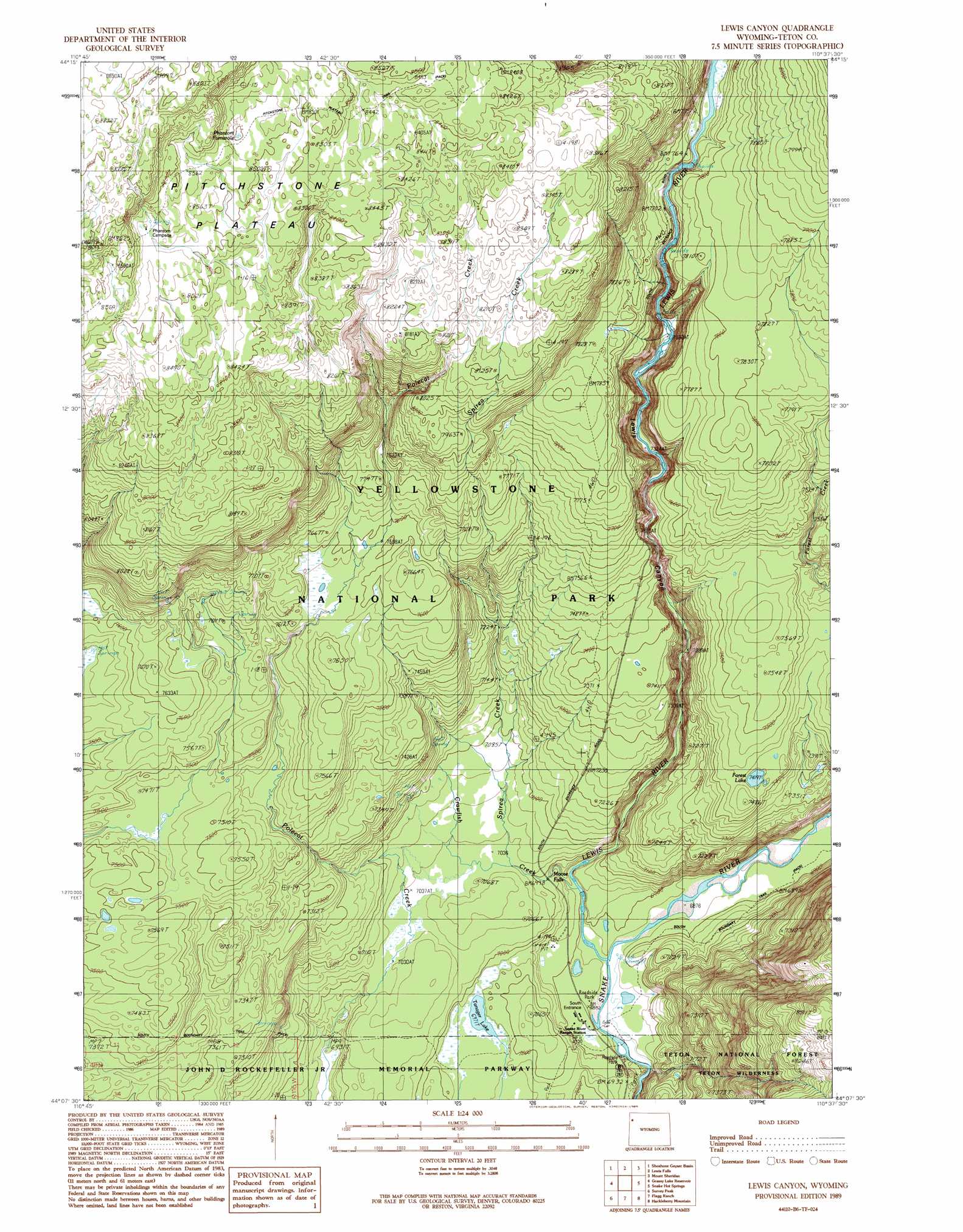
USGS Topo Quad 44110b6 - 1:24,000 scale
| Topo Map Name: | Lewis Canyon |
| USGS Topo Quad ID: | 44110b6 |
| Print Size: | ca. 21 1/4" wide x 27" high |
| Southeast Coordinates: | 44.125° N latitude / 110.625° W longitude |
| Map Center Coordinates: | 44.1875° N latitude / 110.6875° W longitude |
| U.S. State: | WY |
| Filename: | o44110b6.jpg |
| Download Map JPG Image: | Lewis Canyon topo map 1:24,000 scale |
| Map Type: | Topographic |
| Topo Series: | 7.5´ |
| Map Scale: | 1:24,000 |
| Source of Map Images: | United States Geological Survey (USGS) |
| Alternate Map Versions: |
Lewis Canyon WY 1989, updated 1989 Download PDF Buy paper map Lewis Canyon WY 1996, updated 1998 Download PDF Buy paper map Lewis Canyon WY 2012 Download PDF Buy paper map Lewis Canyon WY 2015 Download PDF Buy paper map |
| FStopo: | US Forest Service topo Lewis Canyon is available: Download FStopo PDF Download FStopo TIF |
1:24,000 Topo Quads surrounding Lewis Canyon
Summit Lake |
Old Faithful |
Craig Pass |
West Thumb |
Dot Island |
Trischman Knob |
Shoshone Geyser Basin |
Lewis Falls |
Mount Sheridan |
Heart Lake |
Cave Falls |
Grassy Lake Reservoir |
Lewis Canyon |
Snake Hot Springs |
Mount Hancock |
Hominy Peak |
Survey Peak |
Flagg Ranch |
Huckleberry Mountain |
Bobcat Ridge |
Rammel Mountain |
Ranger Peak |
Colter Bay |
Two Ocean Lake |
Whetstone Mountain |
> Back to 44110a1 at 1:100,000 scale
> Back to 44110a1 at 1:250,000 scale
> Back to U.S. Topo Maps home
Lewis Canyon topo map: Gazetteer
Lewis Canyon: Falls
Moose Falls elevation 2123m 6965′Lewis Canyon: Lakes
Forest Lake elevation 2263m 7424′Tanager Lake elevation 2126m 6975′
Lewis Canyon: Springs
Crawfish Creek Hot Springs elevation 2169m 7116′Crawfish Creek Hot Springs elevation 2274m 7460′
Phantum Fumarole elevation 2591m 8500′
South Entrance Hot Springs elevation 2105m 6906′
Lewis Canyon: Streams
Crawfish Creek elevation 2107m 6912′Lewis River elevation 2098m 6883′
Spirea Creek elevation 2141m 7024′
Lewis Canyon: Valleys
Lewis Canyon elevation 2115m 6938′Lewis Canyon digital topo map on disk
Buy this Lewis Canyon topo map showing relief, roads, GPS coordinates and other geographical features, as a high-resolution digital map file on DVD: