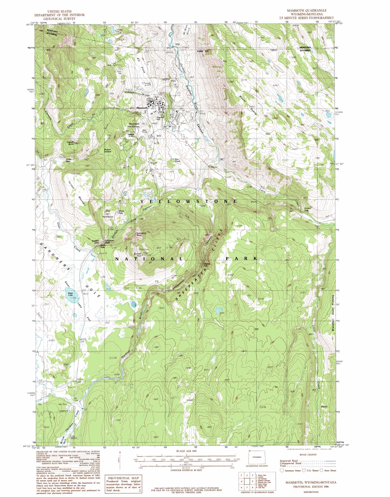
Mammoth Topo Map Wyoming
To zoom in, hover over the map of Mammoth
USGS Topo Quad 44110h6 - 1:24,000 scale
| Topo Map Name: | Mammoth |
| USGS Topo Quad ID: | 44110h6 |
| Print Size: | ca. 21 1/4" wide x 27" high |
| Southeast Coordinates: | 44.875° N latitude / 110.625° W longitude |
| Map Center Coordinates: | 44.9375° N latitude / 110.6875° W longitude |
| U.S. States: | WY, MT |
| Filename: | o44110h6.jpg |
| Download Map JPG Image: | Mammoth topo map 1:24,000 scale |
| Map Type: | Topographic |
| Topo Series: | 7.5´ |
| Map Scale: | 1:24,000 |
| Source of Map Images: | United States Geological Survey (USGS) |
| Alternate Map Versions: |
Mammoth WY 1986, updated 1986 Download PDF Buy paper map Mammoth WY 1986, updated 1986 Download PDF Buy paper map Mammoth WY 2011 Download PDF Buy paper map Mammoth WY 2012 Download PDF Buy paper map Mammoth WY 2015 Download PDF Buy paper map |
1:24,000 Topo Quads surrounding Mammoth
Miner |
Dome Mountain |
Monitor Peak |
Mineral Mountain |
Mount Wallace |
Sportsman Lake |
Electric Peak |
Gardiner |
Ash Mountain |
Specimen Creek |
Joseph Peak |
Quadrant Mountain |
Mammoth |
Blacktail Deer Creek |
Tower Junction |
Three Rivers Peak |
Mount Holmes |
Obsidian Cliff |
Cook Peak |
Mount Washburn |
Mount Jackson |
Madison Junction |
Norris Junction |
Crystal Falls |
Canyon Village |
> Back to 44110e1 at 1:100,000 scale
> Back to 44110a1 at 1:250,000 scale
> Back to U.S. Topo Maps home
Mammoth topo map: Gazetteer
Mammoth: Benches
Highland Terrace elevation 2050m 6725′Main Terrace elevation 1993m 6538′
Opal Terrace elevation 2209m 7247′
Pinyon Terrace elevation 2150m 7053′
Mammoth: Bridges
Sevenmile Bridge elevation 2217m 7273′Sheepeater Canyon Bridge elevation 1791m 5875′
Mammoth: Cliffs
Sheepeater Cliffs elevation 2093m 6866′Mammoth: Falls
Osprey Falls elevation 2017m 6617′Rustic Falls elevation 2198m 7211′
Undine Falls elevation 1977m 6486′
Mammoth: Flats
Elk Plaza elevation 1987m 6519′Mammoth: Gaps
Golden Gate elevation 2170m 7119′Kingman Pass elevation 2170m 7119′
Silver Gate elevation 2152m 7060′
Snow Pass elevation 2276m 7467′
Mammoth: Lakes
Beaver Ponds elevation 1953m 6407′Rye Pond elevation 1890m 6200′
Swan Lake elevation 2217m 7273′
Mammoth: Pillars
The Hoodoos elevation 2174m 7132′Mammoth: Populated Places
Mammoth elevation 1905m 6250′Mammoth: Ridges
Squirrel Springs Ridge elevation 1846m 6056′Mammoth: Springs
Boiling River elevation 1732m 5682′Highland Spring elevation 2055m 6742′
Mammoth Hot Springs elevation 2053m 6735′
Mammoth: Streams
Clematis Creek elevation 1916m 6286′Glen Creek elevation 1827m 5994′
Indian Creek elevation 2232m 7322′
Lava Creek elevation 1775m 5823′
Lupine Creek elevation 2011m 6597′
Obsidian Creek elevation 2217m 7273′
Panther Creek elevation 2252m 7388′
Primrose Creek elevation 1929m 6328′
Mammoth: Summits
Bunsen Peak elevation 2599m 8526′Capitol Hill elevation 1956m 6417′
Cathedral Rock elevation 2313m 7588′
Clagett Butte elevation 2451m 8041′
Liberty Cap elevation 2019m 6624′
Mount Everts elevation 2387m 7831′
Terrace Mountain elevation 2439m 8001′
The Hoodoos elevation 2224m 7296′
Mammoth: Swamps
Swan Lake Flat elevation 2223m 7293′Mammoth: Trails
Beaver Lakes Loop Trail elevation 1991m 6532′Beaver Lakes Loop Trail elevation 1947m 6387′
Sepulcher Loop Trail elevation 2516m 8254′
Mammoth: Valleys
Golden Gate Canyon elevation 1980m 6496′Lava Creek Canyon elevation 1806m 5925′
Sheepeater Canyon elevation 1828m 5997′
Mammoth digital topo map on disk
Buy this Mammoth topo map showing relief, roads, GPS coordinates and other geographical features, as a high-resolution digital map file on DVD: