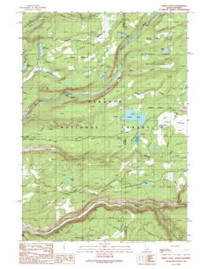
Sheep Falls Topo Map Idaho
To zoom in, hover over the map of Sheep Falls
USGS Topo Quad 44111a1 - 1:24,000 scale
| Topo Map Name: | Sheep Falls |
| USGS Topo Quad ID: | 44111a1 |
| Print Size: | ca. 21 1/4" wide x 27" high |
| Southeast Coordinates: | 44° N latitude / 111° W longitude |
| Map Center Coordinates: | 44.0625° N latitude / 111.0625° W longitude |
| U.S. States: | ID, WY |
| Filename: | o44111a1.jpg |
| Download Map JPG Image: | Sheep Falls topo map 1:24,000 scale |
| Map Type: | Topographic |
| Topo Series: | 7.5´ |
| Map Scale: | 1:24,000 |
| Source of Map Images: | United States Geological Survey (USGS) |
| Alternate Map Versions: |
Sheep Falls ID 1989, updated 1989 Download PDF Buy paper map Sheep Falls ID 1989, updated 1989 Download PDF Buy paper map Sheep Falls ID 2011 Download PDF Buy paper map Sheep Falls ID 2013 Download PDF Buy paper map |
| FStopo: | US Forest Service topo Sheep Falls is available: Download FStopo PDF Download FStopo TIF |
1:24,000 Topo Quads surrounding Sheep Falls
> Back to 44111a1 at 1:100,000 scale
> Back to 44110a1 at 1:250,000 scale
> Back to U.S. Topo Maps home
Sheep Falls topo map: Gazetteer
Sheep Falls: Dams
Bergman Lake Dam elevation 1944m 6377′Indian Lake Dam elevation 1956m 6417′
Sheep Falls: Falls
Sheep Falls elevation 1801m 5908′Sheep Falls: Flats
Long Meadows elevation 1889m 6197′Putney Meadows elevation 1947m 6387′
Squirrel Meadows elevation 1964m 6443′
Sheep Falls: Lakes
Chain Lakes elevation 1917m 6289′Ernest Lake elevation 1993m 6538′
Indian Lake elevation 1957m 6420′
Indian Lake elevation 1953m 6407′
Steele Lake elevation 1935m 6348′
Widgit Lake elevation 1937m 6354′
Sheep Falls: Reservoirs
Bergman Lake elevation 1944m 6377′Bergman Reservoir elevation 1947m 6387′
Indian Lake elevation 1956m 6417′
Paddy Lake elevation 1922m 6305′
Steele Lake elevation 1941m 6368′
Swan Lake elevation 1933m 6341′
Thompson Hole elevation 1893m 6210′
Upper Goose Lake elevation 1882m 6174′
Sheep Falls: Ridges
Elk Point elevation 1928m 6325′Sheep Falls: Springs
Buggy Spring elevation 1916m 6286′Sheep Falls: Streams
Coyote Creek elevation 1876m 6154′Dog Creek elevation 1821m 5974′
Dog Creek elevation 1821m 5974′
Jackass Creek elevation 1896m 6220′
Middle Boone Creek elevation 1943m 6374′
North Boone Creek elevation 1943m 6374′
Winegar Creek elevation 1852m 6076′
Sheep Falls digital topo map on disk
Buy this Sheep Falls topo map showing relief, roads, GPS coordinates and other geographical features, as a high-resolution digital map file on DVD:


