Last Chance Topo Map Idaho
To zoom in, hover over the map of Last Chance
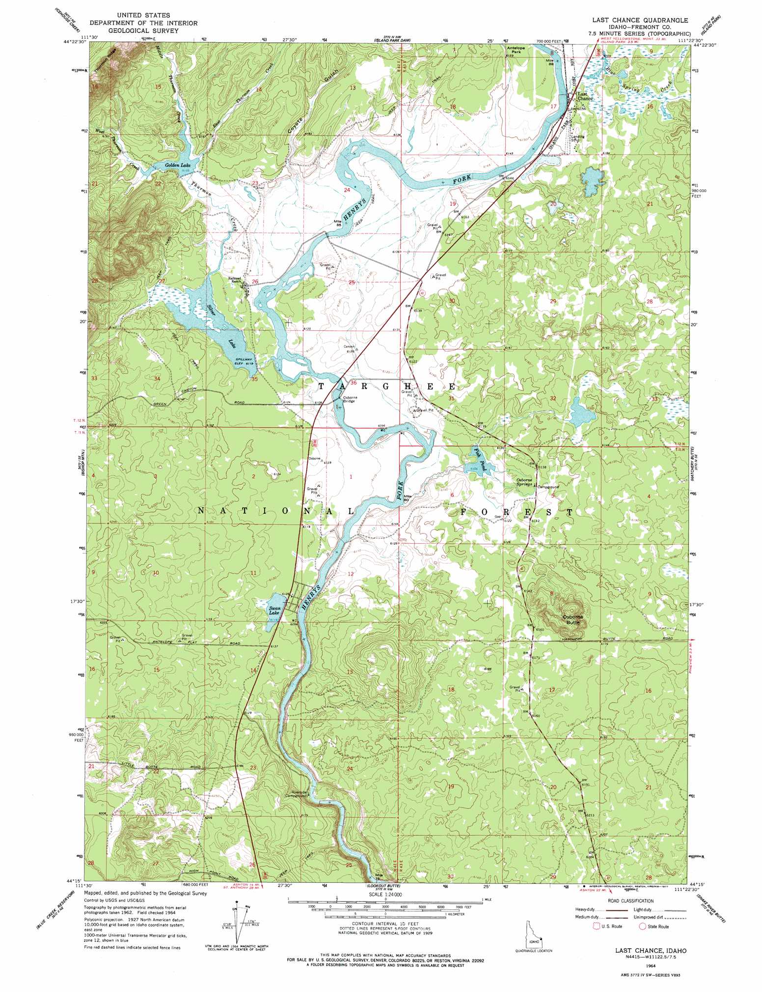
USGS Topo Quad 44111c4 - 1:24,000 scale
| Topo Map Name: | Last Chance |
| USGS Topo Quad ID: | 44111c4 |
| Print Size: | ca. 21 1/4" wide x 27" high |
| Southeast Coordinates: | 44.25° N latitude / 111.375° W longitude |
| Map Center Coordinates: | 44.3125° N latitude / 111.4375° W longitude |
| U.S. State: | ID |
| Filename: | o44111c4.jpg |
| Download Map JPG Image: | Last Chance topo map 1:24,000 scale |
| Map Type: | Topographic |
| Topo Series: | 7.5´ |
| Map Scale: | 1:24,000 |
| Source of Map Images: | United States Geological Survey (USGS) |
| Alternate Map Versions: |
Last Chance ID 1964, updated 1966 Download PDF Buy paper map Last Chance ID 1964, updated 1977 Download PDF Buy paper map Last Chance ID 1964, updated 1977 Download PDF Buy paper map Last Chance ID 2011 Download PDF Buy paper map Last Chance ID 2013 Download PDF Buy paper map |
| FStopo: | US Forest Service topo Last Chance is available: Download FStopo PDF Download FStopo TIF |
1:24,000 Topo Quads surrounding Last Chance
Upper Red Rock Lake |
Mount Jefferson |
Sawtell Peak |
Big Springs |
Reas Pass |
Sheridan Reservoir |
Icehouse Creek |
Island Park Dam |
Island Park |
Latham Spring |
Crystal Butte |
Bishop Mountain |
Last Chance |
Hatchery Butte |
Big Grassy |
Split Butte |
Blue Creek Reservoir |
Lookout Butte |
Snake River Butte |
Warm River Butte |
Black Knoll |
Lemon Lake |
Ashton |
Warm River |
Porcupine Lake |
> Back to 44111a1 at 1:100,000 scale
> Back to 44110a1 at 1:250,000 scale
> Back to U.S. Topo Maps home
Last Chance topo map: Gazetteer
Last Chance: Bridges
Osborne Bridge elevation 1861m 6105′Last Chance: Parks
Harriman State Park elevation 1867m 6125′Last Chance: Populated Places
Last Chance elevation 1875m 6151′Last Chance: Reservoirs
Fish Pond elevation 1862m 6108′Golden Lake elevation 1870m 6135′
Silver Lake elevation 1866m 6122′
Swan Lake elevation 1866m 6122′
Last Chance: Ridges
Thurmon Ridge elevation 2044m 6706′Last Chance: Springs
Osborne Springs elevation 1869m 6131′Last Chance: Streams
Blue Spring Creek elevation 1876m 6154′East Thurmon Creek elevation 1872m 6141′
Middle Thurmon Creek elevation 1872m 6141′
Thurmon Creek elevation 1866m 6122′
West Thurmon Creek elevation 1870m 6135′
Last Chance: Summits
Osborne Butte elevation 1922m 6305′Last Chance: Valleys
Coyote Gulch elevation 1869m 6131′Last Chance digital topo map on disk
Buy this Last Chance topo map showing relief, roads, GPS coordinates and other geographical features, as a high-resolution digital map file on DVD: