Mount Jefferson Topo Map Montana
To zoom in, hover over the map of Mount Jefferson
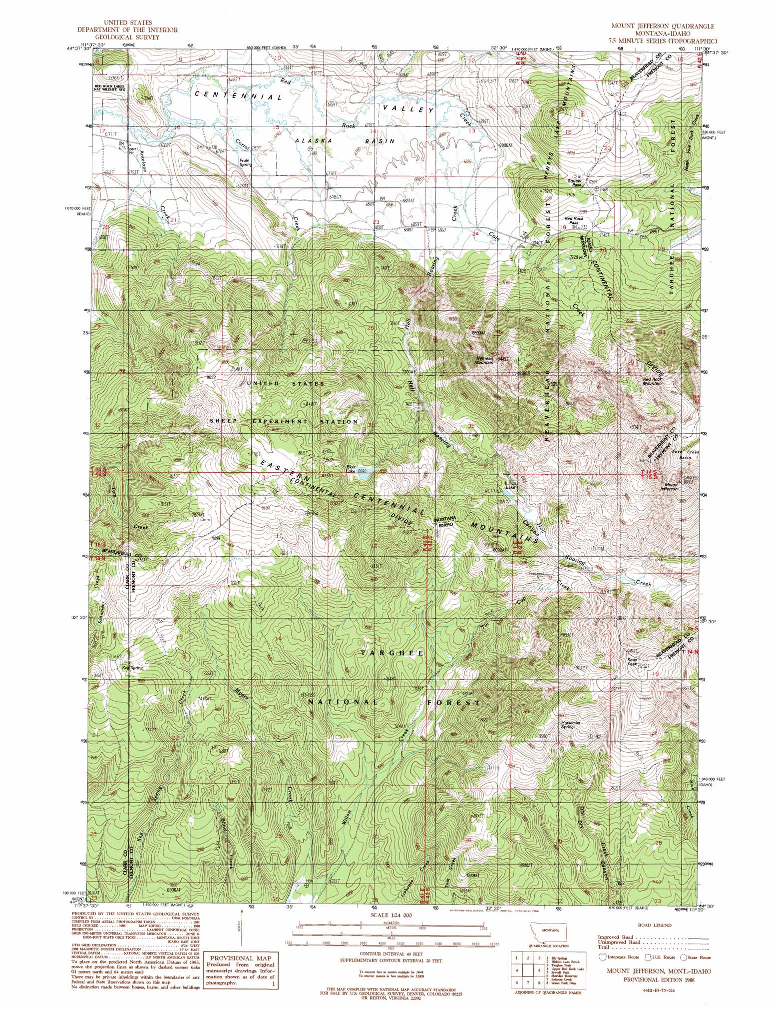
USGS Topo Quad 44111e5 - 1:24,000 scale
| Topo Map Name: | Mount Jefferson |
| USGS Topo Quad ID: | 44111e5 |
| Print Size: | ca. 21 1/4" wide x 27" high |
| Southeast Coordinates: | 44.5° N latitude / 111.5° W longitude |
| Map Center Coordinates: | 44.5625° N latitude / 111.5625° W longitude |
| U.S. States: | MT, ID |
| Filename: | o44111e5.jpg |
| Download Map JPG Image: | Mount Jefferson topo map 1:24,000 scale |
| Map Type: | Topographic |
| Topo Series: | 7.5´ |
| Map Scale: | 1:24,000 |
| Source of Map Images: | United States Geological Survey (USGS) |
| Alternate Map Versions: |
Mount Jefferson MT 1988, updated 1988 Download PDF Buy paper map Mount Jefferson MT 1997, updated 2002 Download PDF Buy paper map Mount Jefferson MT 2011 Download PDF Buy paper map Mount Jefferson MT 2014 Download PDF Buy paper map |
| FStopo: | US Forest Service topo Mount Jefferson is available: Download FStopo PDF Download FStopo TIF |
1:24,000 Topo Quads surrounding Mount Jefferson
Windy Hill |
Freezeout Mountain |
Cliff Lake |
Earthquake Lake |
Hebgen Dam |
Lower Red Rock Lake |
Elk Springs |
Hidden Lake Bench |
Targhee Peak |
Targhee Pass |
Slide Mountain |
Upper Red Rock Lake |
Mount Jefferson |
Sawtell Peak |
Big Springs |
Antelope Valley |
Sheridan Reservoir |
Icehouse Creek |
Island Park Dam |
Island Park |
Pine Butte |
Crystal Butte |
Bishop Mountain |
Last Chance |
Hatchery Butte |
> Back to 44111e1 at 1:100,000 scale
> Back to 44110a1 at 1:250,000 scale
> Back to U.S. Topo Maps home
Mount Jefferson topo map: Gazetteer
Mount Jefferson: Basins
Alaska Basin elevation 2068m 6784′Mount Jefferson: Gaps
Red Rock Pass elevation 2180m 7152′Red Rock Pass elevation 2180m 7152′
Snoo-weh Pass elevation 2214m 7263′
Mount Jefferson: Lakes
Blair Lake elevation 2472m 8110′Lillian Lake elevation 2378m 7801′
Mount Jefferson: Parks
United States Sheep Experiment Station elevation 2639m 8658′Mount Jefferson: Ranges
Centennial Mountains elevation 3102m 10177′Eastern Centennial Mountains elevation 3103m 10180′
Mount Jefferson: Springs
14S01E08DACC01 Spring elevation 2033m 6669′14S01E13BDA_01 Spring elevation 2074m 6804′
14S01E23BCC_01 Spring elevation 2074m 6804′
Fruin Spring elevation 2055m 6742′
Horsemint Spring elevation 2526m 8287′
Keg Spring elevation 2368m 7769′
Mount Jefferson: Streams
Antelope Creek elevation 2034m 6673′Cole Creek elevation 2073m 6801′
Corral Creek elevation 2045m 6709′
Hell Roaring Creek elevation 2063m 6768′
Tin Cup Creek elevation 2184m 7165′
Mount Jefferson: Summits
Mount Jefferson elevation 3074m 10085′Mount Jefferson elevation 3097m 10160′
Nemesis Mountain elevation 2846m 9337′
Reas Peak elevation 2850m 9350′
Reas Peak elevation 2850m 9350′
Red Rock Mountain elevation 2896m 9501′
Red Rock Mountain elevation 2895m 9498′
Mount Jefferson: Trails
Blind Creek Trail elevation 2257m 7404′Dry Creek Trail elevation 2599m 8526′
Myers Creek Trail elevation 2336m 7664′
Tin Cup Trail elevation 2249m 7378′
Willow Creek Trail elevation 2085m 6840′
Mount Jefferson: Valleys
Hell Roaring Canyon elevation 2110m 6922′Mount Jefferson: Wells
14S01E22ACBB01 Well elevation 2065m 6774′14S01E22DBAA01 Well elevation 2091m 6860′
14S01E24CDAA01 Well elevation 2105m 6906′
Mount Jefferson digital topo map on disk
Buy this Mount Jefferson topo map showing relief, roads, GPS coordinates and other geographical features, as a high-resolution digital map file on DVD: