Hidden Lake Bench Topo Map Montana
To zoom in, hover over the map of Hidden Lake Bench
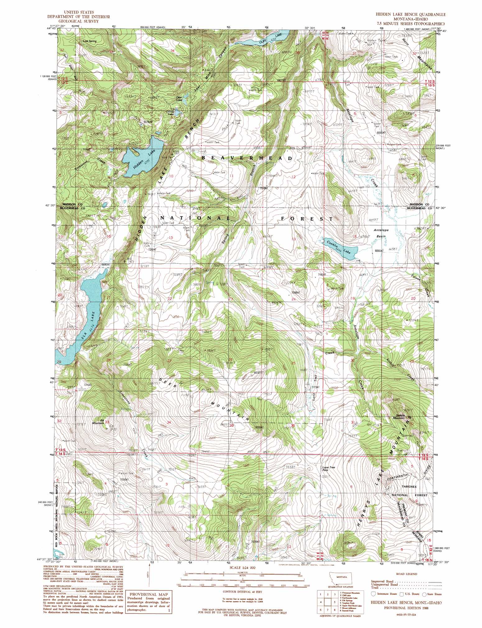
USGS Topo Quad 44111f5 - 1:24,000 scale
| Topo Map Name: | Hidden Lake Bench |
| USGS Topo Quad ID: | 44111f5 |
| Print Size: | ca. 21 1/4" wide x 27" high |
| Southeast Coordinates: | 44.625° N latitude / 111.5° W longitude |
| Map Center Coordinates: | 44.6875° N latitude / 111.5625° W longitude |
| U.S. States: | MT, ID |
| Filename: | o44111f5.jpg |
| Download Map JPG Image: | Hidden Lake Bench topo map 1:24,000 scale |
| Map Type: | Topographic |
| Topo Series: | 7.5´ |
| Map Scale: | 1:24,000 |
| Source of Map Images: | United States Geological Survey (USGS) |
| Alternate Map Versions: |
Hidden Lake Bench MT 1988, updated 1988 Download PDF Buy paper map Hidden Lake Bench MT 1997, updated 2002 Download PDF Buy paper map Hidden Lake Bench MT 2011 Download PDF Buy paper map Hidden Lake Bench MT 2014 Download PDF Buy paper map |
| FStopo: | US Forest Service topo Hidden Lake Bench is available: Download FStopo PDF Download FStopo TIF |
1:24,000 Topo Quads surrounding Hidden Lake Bench
Bighorn Mountain |
Granite Mountain |
Squaw Creek |
Hilgard Peak |
Pika Point |
Windy Hill |
Freezeout Mountain |
Cliff Lake |
Earthquake Lake |
Hebgen Dam |
Lower Red Rock Lake |
Elk Springs |
Hidden Lake Bench |
Targhee Peak |
Targhee Pass |
Slide Mountain |
Upper Red Rock Lake |
Mount Jefferson |
Sawtell Peak |
Big Springs |
Antelope Valley |
Sheridan Reservoir |
Icehouse Creek |
Island Park Dam |
Island Park |
> Back to 44111e1 at 1:100,000 scale
> Back to 44110a1 at 1:250,000 scale
> Back to U.S. Topo Maps home
Hidden Lake Bench topo map: Gazetteer
Hidden Lake Bench: Basins
Antelope Basin elevation 2032m 6666′Hidden Lake Bench: Benches
Hidden Lake Bench elevation 2239m 7345′Hidden Lake Bench: Gaps
Lone Tree Pass elevation 2299m 7542′Hidden Lake Bench: Lakes
Conklin Lake elevation 2033m 6669′Elk Lake elevation 2035m 6676′
Goose Lake elevation 2001m 6564′
Hidden Lake elevation 2011m 6597′
Otter Lake elevation 1987m 6519′
Hidden Lake Bench: Ranges
Horn Mountains elevation 2328m 7637′Hidden Lake Bench: Springs
13S01E28AACD01 Spring elevation 2220m 7283′13S01E33AAC_01 Spring elevation 2227m 7306′
13S01E36DDD_01 Spring elevation 2260m 7414′
14S02E06CCCB01 Spring elevation 2260m 7414′
14S02E07CBAD01 Spring elevation 2208m 7244′
Lost Spring elevation 2319m 7608′
Hidden Lake Bench: Streams
Antelope Creek elevation 1943m 6374′Anthill Creek elevation 2107m 6912′
Brimstone Creek elevation 2033m 6669′
Limestone Creek elevation 2036m 6679′
Lone Tree Creek elevation 2098m 6883′
Poison Creek elevation 2036m 6679′
Spring Branch elevation 1935m 6348′
Hidden Lake Bench: Summits
Deer Mountain elevation 2560m 8398′Elk Mountain elevation 2479m 8133′
Saddle Mountain elevation 2528m 8293′
Hidden Lake Bench: Valleys
Lost Mine Canyon elevation 1929m 6328′Hidden Lake Bench digital topo map on disk
Buy this Hidden Lake Bench topo map showing relief, roads, GPS coordinates and other geographical features, as a high-resolution digital map file on DVD: