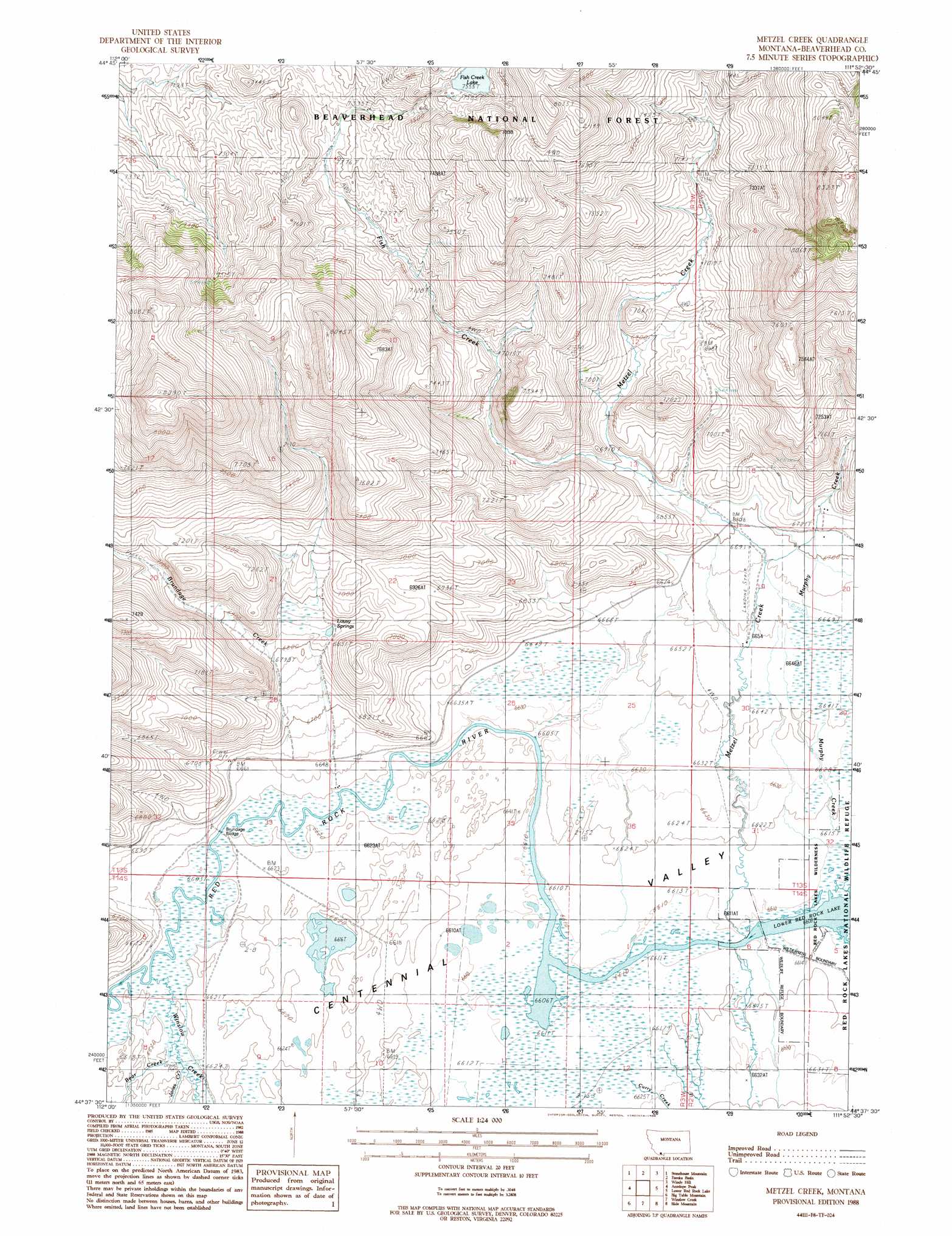
Metzel Creek Topo Map Montana
To zoom in, hover over the map of Metzel Creek
USGS Topo Quad 44111f8 - 1:24,000 scale
| Topo Map Name: | Metzel Creek |
| USGS Topo Quad ID: | 44111f8 |
| Print Size: | ca. 21 1/4" wide x 27" high |
| Southeast Coordinates: | 44.625° N latitude / 111.875° W longitude |
| Map Center Coordinates: | 44.6875° N latitude / 111.9375° W longitude |
| U.S. State: | MT |
| Filename: | o44111f8.jpg |
| Download Map JPG Image: | Metzel Creek topo map 1:24,000 scale |
| Map Type: | Topographic |
| Topo Series: | 7.5´ |
| Map Scale: | 1:24,000 |
| Source of Map Images: | United States Geological Survey (USGS) |
| Alternate Map Versions: |
Metzel Creek MT 1988, updated 1988 Download PDF Buy paper map Metzel Creek MT 1997, updated 2002 Download PDF Buy paper map Metzel Creek MT 2011 Download PDF Buy paper map Metzel Creek MT 2014 Download PDF Buy paper map |
| FStopo: | US Forest Service topo Metzel Creek is available: Download FStopo PDF Download FStopo TIF |
1:24,000 Topo Quads surrounding Metzel Creek
Swamp Creek |
Spur Mountain |
Iron Creek |
Bighorn Mountain |
Granite Mountain |
Antone Peak |
Stonehouse Mountain |
Eureka Basin |
Windy Hill |
Freezeout Mountain |
Wolverine Creek |
Antelope Peak |
Metzel Creek |
Lower Red Rock Lake |
Elk Springs |
Corral Creek |
Big Table Mountain |
Winslow Creek |
Slide Mountain |
Upper Red Rock Lake |
Spencer North |
Lookout Point |
Kilgore |
Antelope Valley |
Sheridan Reservoir |
> Back to 44111e1 at 1:100,000 scale
> Back to 44110a1 at 1:250,000 scale
> Back to U.S. Topo Maps home
Metzel Creek topo map: Gazetteer
Metzel Creek: Airports
Metzel Creek Airport elevation 2034m 6673′Metzel Creek: Bridges
Brundage Bridge elevation 2016m 6614′Metzel Creek: Dams
Fish Dam elevation 2315m 7595′Metzel Creek: Lakes
Fish Creek Lake elevation 2304m 7559′Metzel Creek: Reservoirs
Fish Reservoir elevation 2315m 7595′Metzel Creek: Springs
13S02W18ADC_01 Spring elevation 2084m 6837′13S03W22CCBC01 Spring elevation 2086m 6843′
13S03W22DAAB01 Spring elevation 2097m 6879′
13S03W23ABD_01 Spring elevation 2079m 6820′
Lousy Springs elevation 2085m 6840′
Metzel Creek: Streams
Bear Creek elevation 2019m 6624′Brundage Creek elevation 2016m 6614′
Curry Creek elevation 2016m 6614′
Fish Creek elevation 2038m 6686′
Jones Creek elevation 2019m 6624′
Metzel Creek elevation 2016m 6614′
Murphy Creek elevation 2019m 6624′
Red Rock Creek elevation 2015m 6610′
Winslow Creek elevation 2016m 6614′
Metzel Creek: Wells
13S02W17CCBD01 Well elevation 2057m 6748′13S02W19CDDC01 Well elevation 2031m 6663′
13S03W34BBCC01 Well elevation 2018m 6620′
Metzel Creek digital topo map on disk
Buy this Metzel Creek topo map showing relief, roads, GPS coordinates and other geographical features, as a high-resolution digital map file on DVD: