Squaw Creek Topo Map Montana
To zoom in, hover over the map of Squaw Creek
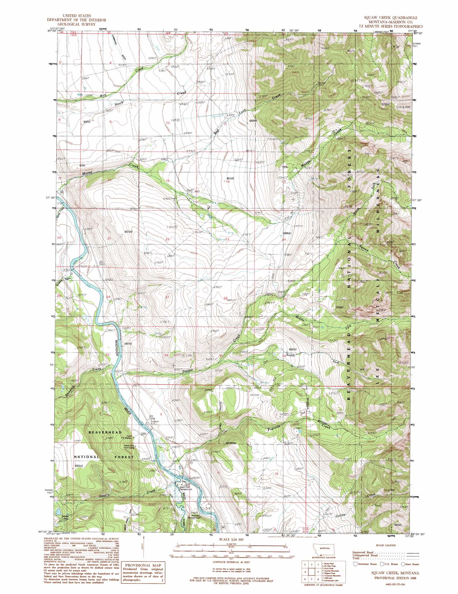
USGS Topo Quad 44111h5 - 1:24,000 scale
| Topo Map Name: | Squaw Creek |
| USGS Topo Quad ID: | 44111h5 |
| Print Size: | ca. 21 1/4" wide x 27" high |
| Southeast Coordinates: | 44.875° N latitude / 111.5° W longitude |
| Map Center Coordinates: | 44.9375° N latitude / 111.5625° W longitude |
| U.S. State: | MT |
| Filename: | o44111h5.jpg |
| Download Map JPG Image: | Squaw Creek topo map 1:24,000 scale |
| Map Type: | Topographic |
| Topo Series: | 7.5´ |
| Map Scale: | 1:24,000 |
| Source of Map Images: | United States Geological Survey (USGS) |
| Alternate Map Versions: |
Squaw Creek MT 1988, updated 1989 Download PDF Buy paper map Bad Luck Creek MT 1997, updated 2001 Download PDF Buy paper map Bad Luck Creek MT 2011 Download PDF Buy paper map Bad Luck Creek MT 2014 Download PDF Buy paper map |
| FStopo: | US Forest Service topo Bad Luck Creek is available: Download FStopo PDF Download FStopo TIF |
1:24,000 Topo Quads surrounding Squaw Creek
Varney |
Cameron |
Lake Cameron |
Sphinx Mountain |
Ousel Falls |
Broomtail Ridge |
Bucks Nest |
No Man Peak |
Koch Peak |
Lincoln Mountain |
Bighorn Mountain |
Granite Mountain |
Squaw Creek |
Hilgard Peak |
Pika Point |
Windy Hill |
Freezeout Mountain |
Cliff Lake |
Earthquake Lake |
Hebgen Dam |
Lower Red Rock Lake |
Elk Springs |
Hidden Lake Bench |
Targhee Peak |
Targhee Pass |
> Back to 44111e1 at 1:100,000 scale
> Back to 44110a1 at 1:250,000 scale
> Back to U.S. Topo Maps home
Squaw Creek topo map: Gazetteer
Squaw Creek: Bridges
Hutchins Bridge elevation 1792m 5879′Squaw Creek: Canals
Papoose Ditch elevation 1884m 6181′Squaw Creek: Parks
Raynolds Pass Historical Marker elevation 1787m 5862′Squaw Creek: Post Offices
Lyon Post Office (historical) elevation 1792m 5879′Squaw Creek: Springs
10S01E04CCCC01 Spring elevation 1867m 6125′10S01E09BBB_01 Spring elevation 1860m 6102′
10S01E09BBBB01 Spring elevation 1855m 6085′
10S01E09BBC_01 Spring elevation 1854m 6082′
10S01E28DDD_01 Spring elevation 1834m 6017′
11S01E13DBB_01 Spring elevation 1965m 6446′
Wolf Creek Hot Spring elevation 1854m 6082′
Squaw Creek: Streams
Bad Luck Creek elevation 1894m 6213′Gazelle Creek elevation 1790m 5872′
Horse Creek elevation 1750m 5741′
Middle Fork Sun Creek elevation 1939m 6361′
North Fork Sun Creek elevation 2234m 7329′
Papoose Creek elevation 1791m 5875′
Quaking Aspen Creek elevation 1758m 5767′
South Fork Sun Creek elevation 1908m 6259′
Standard Creek elevation 1775m 5823′
Sun Creek elevation 1775m 5823′
West Fork Madison River elevation 1790m 5872′
Squaw Creek: Wells
10S01E15DDAD01 Well elevation 1963m 6440′10S01E17DAB_01 Well elevation 1867m 6125′
10S01E17DAB_02 Well elevation 1867m 6125′
10S01E21CCDD01 Well elevation 1777m 5830′
10S01E33DDB_01 Well elevation 1828m 5997′
11S01E03CACB01 Well elevation 1789m 5869′
11S01E03CCCB01 Well elevation 1803m 5915′
11S01E10DACD01 Well elevation 1793m 5882′
11S01E14BABD01 Well elevation 1808m 5931′
Squaw Creek digital topo map on disk
Buy this Squaw Creek topo map showing relief, roads, GPS coordinates and other geographical features, as a high-resolution digital map file on DVD: