Lookout Point Topo Map Idaho
To zoom in, hover over the map of Lookout Point
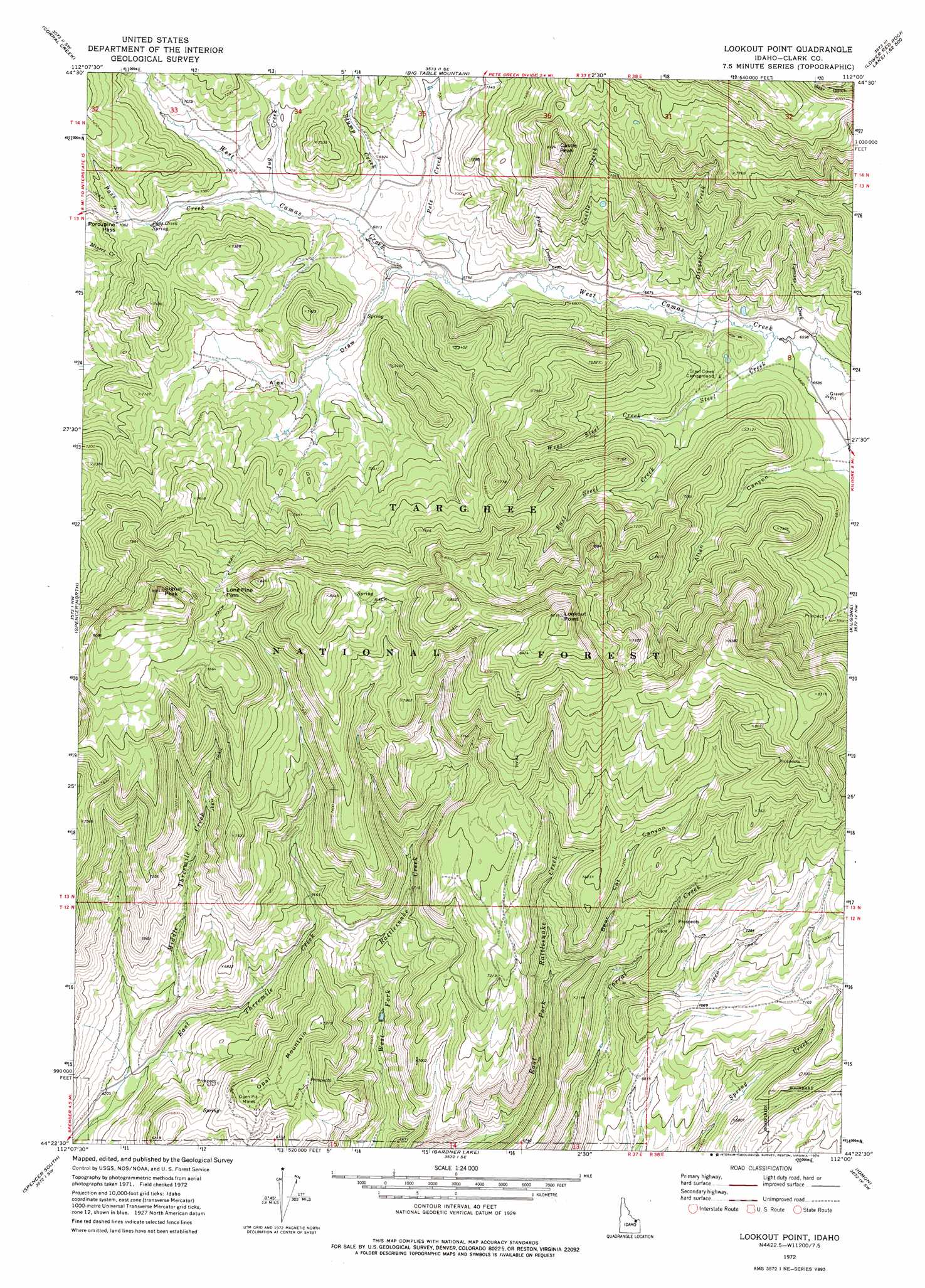
USGS Topo Quad 44112d1 - 1:24,000 scale
| Topo Map Name: | Lookout Point |
| USGS Topo Quad ID: | 44112d1 |
| Print Size: | ca. 21 1/4" wide x 27" high |
| Southeast Coordinates: | 44.375° N latitude / 112° W longitude |
| Map Center Coordinates: | 44.4375° N latitude / 112.0625° W longitude |
| U.S. State: | ID |
| Filename: | o44112d1.jpg |
| Download Map JPG Image: | Lookout Point topo map 1:24,000 scale |
| Map Type: | Topographic |
| Topo Series: | 7.5´ |
| Map Scale: | 1:24,000 |
| Source of Map Images: | United States Geological Survey (USGS) |
| Alternate Map Versions: |
Lookout Point ID 1972, updated 1976 Download PDF Buy paper map Lookout Point ID 2011 Download PDF Buy paper map Lookout Point ID 2013 Download PDF Buy paper map |
| FStopo: | US Forest Service topo Lookout Point is available: Download FStopo PDF Download FStopo TIF |
1:24,000 Topo Quads surrounding Lookout Point
Lima Dam |
Wolverine Creek |
Antelope Peak |
Metzel Creek |
Lower Red Rock Lake |
Monida |
Corral Creek |
Big Table Mountain |
Winslow Creek |
Slide Mountain |
Paul Reservoir |
Spencer North |
Lookout Point |
Kilgore |
Antelope Valley |
Thunder Gulch |
Spencer South |
Gardner Lake |
Idmon |
Pine Butte |
Lone Butte |
Dubois |
Dubois Ne |
Snowshoe Butte |
Split Rock |
> Back to 44112a1 at 1:100,000 scale
> Back to 44112a1 at 1:250,000 scale
> Back to U.S. Topo Maps home
Lookout Point topo map: Gazetteer
Lookout Point: Gaps
Lone Pine Pass elevation 2417m 7929′Porcupine Pass elevation 2157m 7076′
Lookout Point: Springs
Pass Creek Spring elevation 2142m 7027′Lookout Point: Streams
Castle Creek elevation 2044m 6706′Disaster Creek elevation 2019m 6624′
East Steel Creek elevation 2046m 6712′
East Threemile Creek elevation 1862m 6108′
Frazier Creek elevation 2044m 6706′
Jug Creek elevation 2093m 6866′
Lymans Creek elevation 2022m 6633′
Middle Threemile Creek elevation 1862m 6108′
Pass Creek elevation 2095m 6873′
Pete Creek elevation 2055m 6742′
Steel Creek elevation 2016m 6614′
Stump Creek elevation 2082m 6830′
West Steel Creek elevation 2046m 6712′
Lookout Point: Summits
Castle Peak elevation 2468m 8097′Lookout Point elevation 2642m 8667′
Opal Mountain elevation 2198m 7211′
Signal Peak elevation 2602m 8536′
Lookout Point: Valleys
Alex Draw elevation 2073m 6801′Allan Canyon elevation 2023m 6637′
Bear Cat Canyon elevation 2016m 6614′
Lookout Point digital topo map on disk
Buy this Lookout Point topo map showing relief, roads, GPS coordinates and other geographical features, as a high-resolution digital map file on DVD: