Eighteenmile Peak Topo Map Montana
To zoom in, hover over the map of Eighteenmile Peak
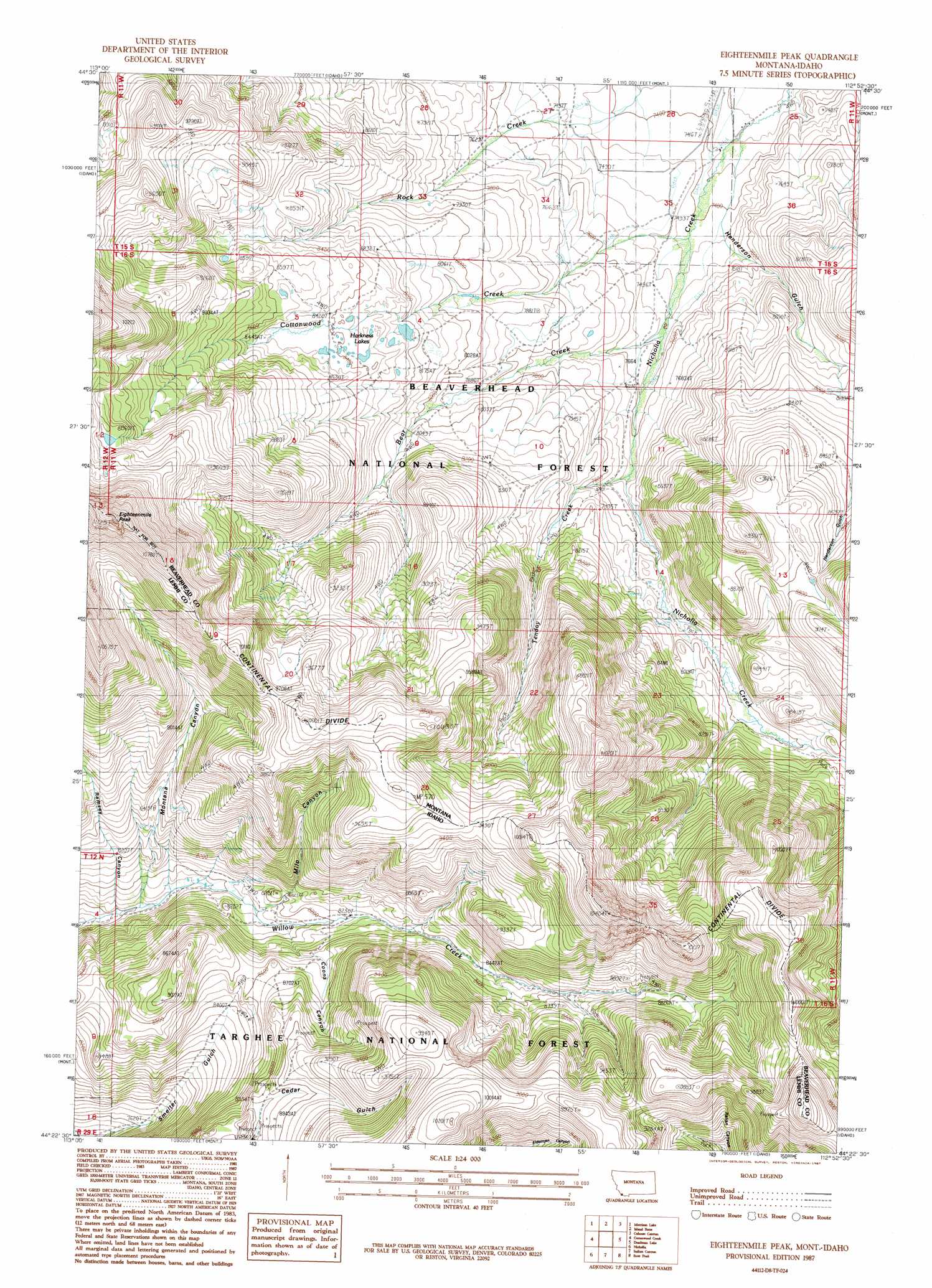
USGS Topo Quad 44112d8 - 1:24,000 scale
| Topo Map Name: | Eighteenmile Peak |
| USGS Topo Quad ID: | 44112d8 |
| Print Size: | ca. 21 1/4" wide x 27" high |
| Southeast Coordinates: | 44.375° N latitude / 112.875° W longitude |
| Map Center Coordinates: | 44.4375° N latitude / 112.9375° W longitude |
| U.S. States: | MT, ID |
| Filename: | o44112d8.jpg |
| Download Map JPG Image: | Eighteenmile Peak topo map 1:24,000 scale |
| Map Type: | Topographic |
| Topo Series: | 7.5´ |
| Map Scale: | 1:24,000 |
| Source of Map Images: | United States Geological Survey (USGS) |
| Alternate Map Versions: |
Eighteenmile Peak MT 1987, updated 1987 Download PDF Buy paper map Eighteenmile Peak MT 1987, updated 1987 Download PDF Buy paper map Eighteenmile Peak MT 1997, updated 2002 Download PDF Buy paper map Eighteenmile Peak MT 2011 Download PDF Buy paper map Eighteenmile Peak MT 2014 Download PDF Buy paper map |
| FStopo: | US Forest Service topo Eighteenmile Peak is available: Download FStopo PDF Download FStopo TIF |
1:24,000 Topo Quads surrounding Eighteenmile Peak
Reservoir Creek |
Tepee Mountain |
Graphite Mountain |
Dixon Mountain |
Dell |
Powderhorn Gulch |
Morrison Lake |
Island Butte |
Caboose Canyon |
Gallagher Gulch |
Gilmore Summit |
Cottonwood Creek |
Eighteenmile Peak |
Deadman Lake |
Fritz Peak |
Coal Kiln Canyon |
Nicholia |
Italian Canyon |
Scott Peak |
Heart Mountain |
Bell Mountain |
Diamond Peak |
Blue Dome |
Copper Mountain |
Shamrock Gulch |
> Back to 44112a1 at 1:100,000 scale
> Back to 44112a1 at 1:250,000 scale
> Back to U.S. Topo Maps home
Eighteenmile Peak topo map: Gazetteer
Eighteenmile Peak: Lakes
Harkness Lakes elevation 2476m 8123′Eighteenmile Peak: Mines
NE SW Section 7 Mine elevation 2874m 9429′Eighteenmile Peak: Streams
Bear Creek elevation 2283m 7490′Cottonwood Creek elevation 2263m 7424′
Tendoy Creek elevation 2338m 7670′
Eighteenmile Peak: Summits
Eighteenmile Peak elevation 3344m 10971′Eighteenmile Peak elevation 3347m 10980′
Eighteenmile Peak: Valleys
Coons Canyon elevation 2566m 8418′Henderson Gulch elevation 2477m 8126′
Milo Canyon elevation 2437m 7995′
Montana Canyon elevation 2407m 7896′
Ramsey Canyon elevation 2372m 7782′
Eighteenmile Peak digital topo map on disk
Buy this Eighteenmile Peak topo map showing relief, roads, GPS coordinates and other geographical features, as a high-resolution digital map file on DVD: