Caboose Canyon Topo Map Montana
To zoom in, hover over the map of Caboose Canyon
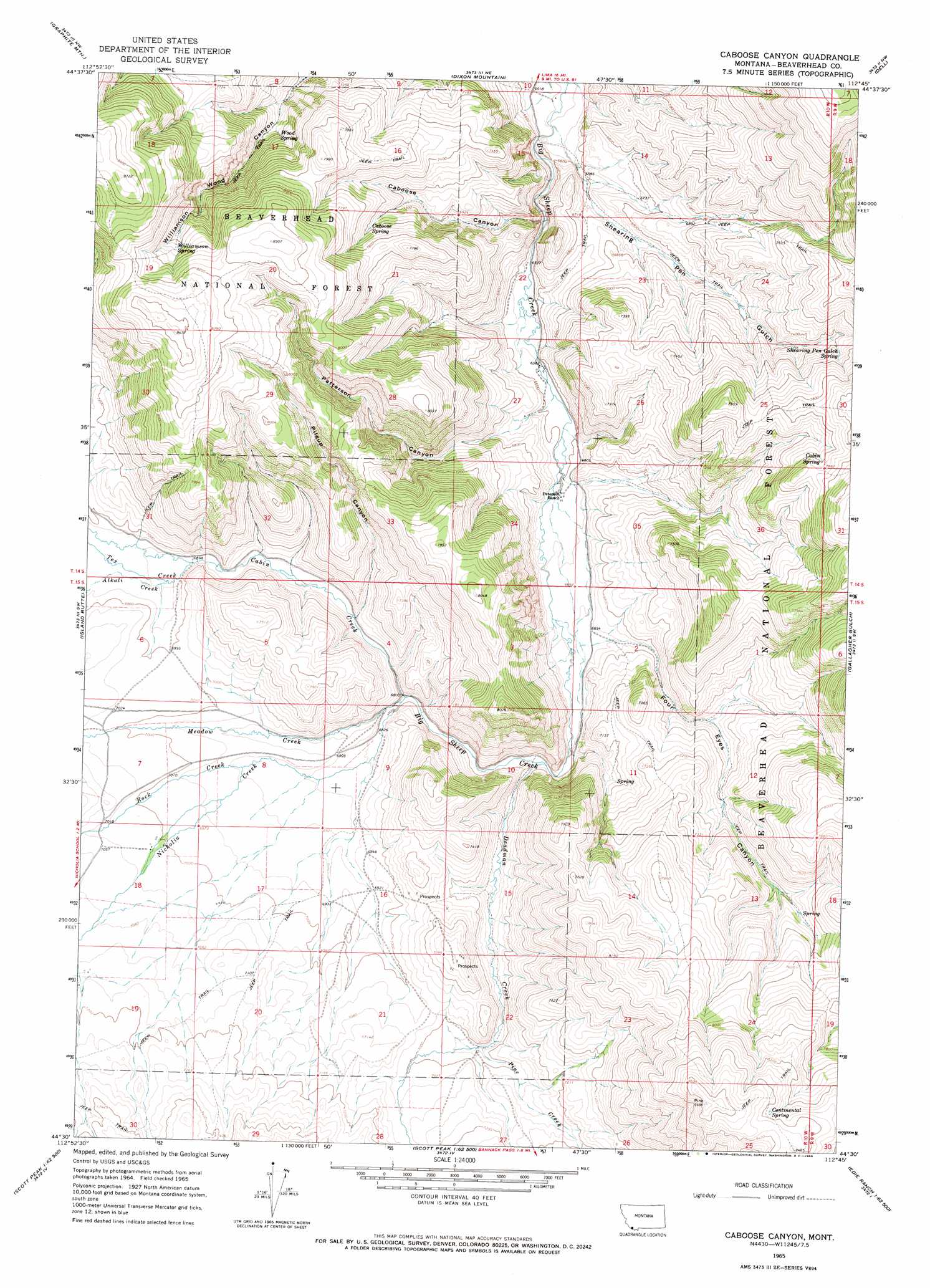
USGS Topo Quad 44112e7 - 1:24,000 scale
| Topo Map Name: | Caboose Canyon |
| USGS Topo Quad ID: | 44112e7 |
| Print Size: | ca. 21 1/4" wide x 27" high |
| Southeast Coordinates: | 44.5° N latitude / 112.75° W longitude |
| Map Center Coordinates: | 44.5625° N latitude / 112.8125° W longitude |
| U.S. State: | MT |
| Filename: | o44112e7.jpg |
| Download Map JPG Image: | Caboose Canyon topo map 1:24,000 scale |
| Map Type: | Topographic |
| Topo Series: | 7.5´ |
| Map Scale: | 1:24,000 |
| Source of Map Images: | United States Geological Survey (USGS) |
| Alternate Map Versions: |
Caboose Canyon MT 1965, updated 1968 Download PDF Buy paper map Caboose Canyon MT 1965, updated 1968 Download PDF Buy paper map Caboose Canyon MT 1997, updated 2002 Download PDF Buy paper map Caboose Canyon MT 2011 Download PDF Buy paper map Caboose Canyon MT 2014 Download PDF Buy paper map |
| FStopo: | US Forest Service topo Caboose Canyon is available: Download FStopo PDF Download FStopo TIF |
1:24,000 Topo Quads surrounding Caboose Canyon
Medicine Lodge Peak |
Deer Canyon |
Kidd |
Briggs Ranch |
Rock Island Ranch |
Tepee Mountain |
Graphite Mountain |
Dixon Mountain |
Dell |
Lima |
Morrison Lake |
Island Butte |
Caboose Canyon |
Gallagher Gulch |
Lima Peaks |
Cottonwood Creek |
Eighteenmile Peak |
Deadman Lake |
Fritz Peak |
Edie Creek |
Nicholia |
Italian Canyon |
Scott Peak |
Heart Mountain |
Rocky Creek |
> Back to 44112e1 at 1:100,000 scale
> Back to 44112a1 at 1:250,000 scale
> Back to U.S. Topo Maps home
Caboose Canyon topo map: Gazetteer
Caboose Canyon: Mines
SE SE Section 16 Mine elevation 2176m 7139′Sun Number 12 Mine elevation 2191m 7188′
Caboose Canyon: Springs
Cabin Spring elevation 2378m 7801′Caboose Spring elevation 2245m 7365′
Continental Spring elevation 2553m 8375′
Shearing Pen Gulch Spring elevation 2277m 7470′
Williamson Spring elevation 2395m 7857′
Wood Spring elevation 2195m 7201′
Caboose Canyon: Streams
Alkali Creek elevation 2108m 6916′Cabin Creek elevation 2064m 6771′
Deadman Creek elevation 2056m 6745′
Meadow Creek elevation 2074m 6804′
Nicholia Creek elevation 2074m 6804′
Pine Creek elevation 2117m 6945′
Rock Creek elevation 2109m 6919′
Tex Creek elevation 2103m 6899′
Caboose Canyon: Valleys
Caboose Canyon elevation 1997m 6551′Four Eyes Canyon elevation 2048m 6719′
Patterson Canyon elevation 2011m 6597′
Pileup Canyon elevation 2087m 6847′
Shearing Pen Gulch elevation 1983m 6505′
Caboose Canyon digital topo map on disk
Buy this Caboose Canyon topo map showing relief, roads, GPS coordinates and other geographical features, as a high-resolution digital map file on DVD: