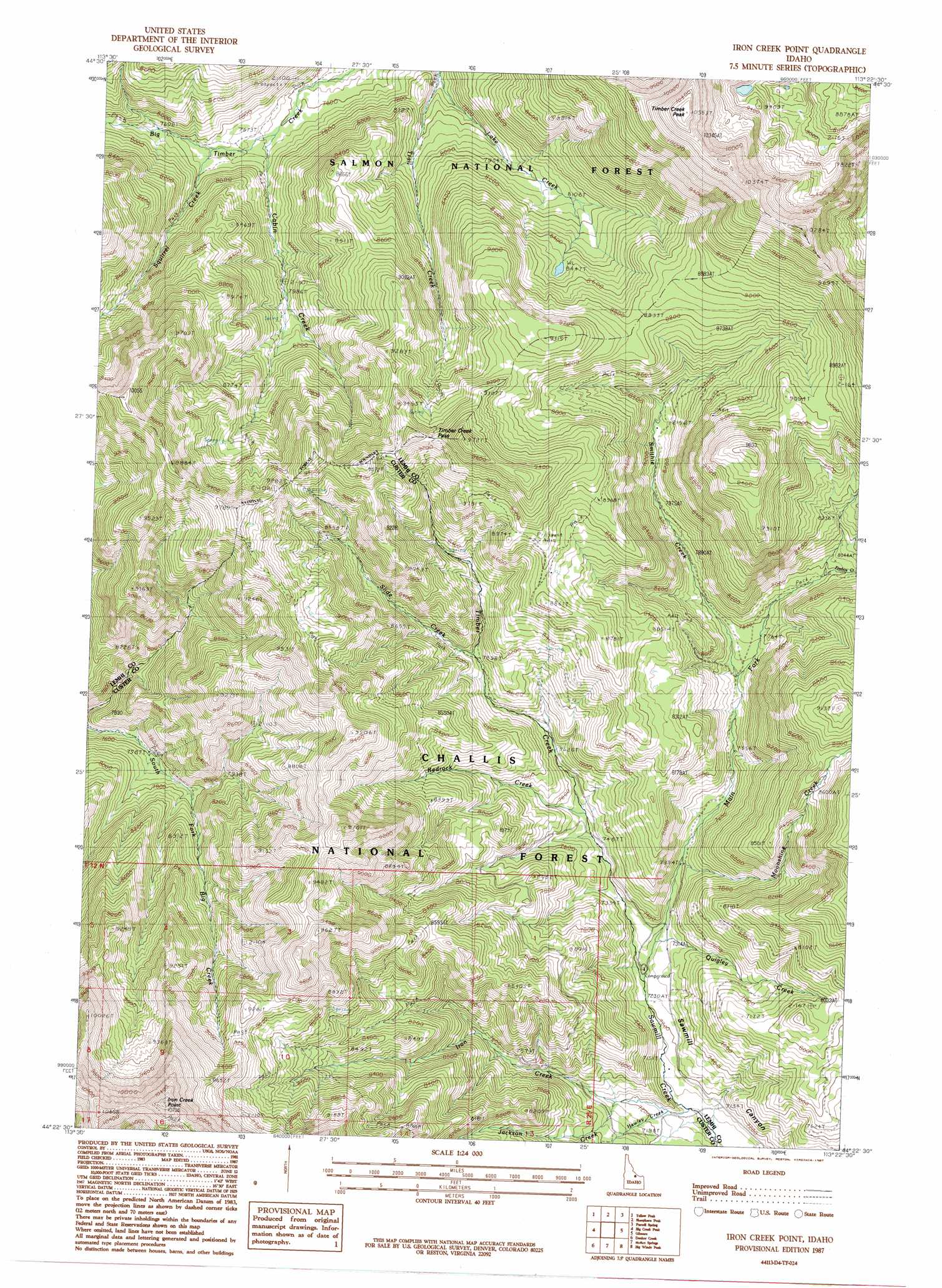
Iron Creek Point Topo Map Idaho
To zoom in, hover over the map of Iron Creek Point
USGS Topo Quad 44113d4 - 1:24,000 scale
| Topo Map Name: | Iron Creek Point |
| USGS Topo Quad ID: | 44113d4 |
| Print Size: | ca. 21 1/4" wide x 27" high |
| Southeast Coordinates: | 44.375° N latitude / 113.375° W longitude |
| Map Center Coordinates: | 44.4375° N latitude / 113.4375° W longitude |
| U.S. State: | ID |
| Filename: | o44113d4.jpg |
| Download Map JPG Image: | Iron Creek Point topo map 1:24,000 scale |
| Map Type: | Topographic |
| Topo Series: | 7.5´ |
| Map Scale: | 1:24,000 |
| Source of Map Images: | United States Geological Survey (USGS) |
| Alternate Map Versions: |
Iron Creek Point ID 1987, updated 1987 Download PDF Buy paper map Iron Creek Point ID 2011 Download PDF Buy paper map Iron Creek Point ID 2013 Download PDF Buy paper map |
| FStopo: | US Forest Service topo Iron Creek Point is available: Download FStopo PDF Download FStopo TIF |
1:24,000 Topo Quads surrounding Iron Creek Point
Mogg Mountain |
Stroud Creek |
West Of Leadore |
Leadore |
Reservoir Creek |
Patterson |
Yellow Peak |
Sheephorn Peak |
Purcell Spring |
Powderhorn Gulch |
Donkey Hills Nw |
Big Creek Peak |
Iron Creek Point |
Gilmore |
Gilmore Summit |
Spring Hill |
Donkey Creek |
Moffett Springs |
Big Windy Peak |
Coal Kiln Canyon |
Burnt Creek |
Short Creek |
Red Hills |
Mulkey Bar |
Bell Mountain |
> Back to 44113a1 at 1:100,000 scale
> Back to 44112a1 at 1:250,000 scale
> Back to U.S. Topo Maps home
Iron Creek Point topo map: Gazetteer
Iron Creek Point: Cliffs
Iron Creek Point elevation 3212m 10538′Iron Creek Point: Gaps
Timber Creek Pass elevation 2838m 9311′Iron Creek Point: Streams
Cabin Creek elevation 2310m 7578′Firebox Creek elevation 2427m 7962′
Hawley Creek elevation 2176m 7139′
Iron Creek elevation 2165m 7103′
Jackson Creek elevation 2207m 7240′
Lake Creek elevation 2328m 7637′
Main Fork elevation 2208m 7244′
Moonshine Creek elevation 2260m 7414′
Quigley Creek elevation 2210m 7250′
Redrock Creek elevation 2291m 7516′
Slide Creek elevation 2409m 7903′
Smithie Creek elevation 2343m 7687′
South Fork Big Creek elevation 2370m 7775′
Squirrel Creek elevation 2349m 7706′
Timber Creek elevation 2207m 7240′
Iron Creek Point: Summits
Timber Creek Peak elevation 3214m 10544′Iron Creek Point: Trails
Snowbank Trail elevation 2724m 8937′Iron Creek Point digital topo map on disk
Buy this Iron Creek Point topo map showing relief, roads, GPS coordinates and other geographical features, as a high-resolution digital map file on DVD: