West Of Leadore Topo Map Idaho
To zoom in, hover over the map of West Of Leadore
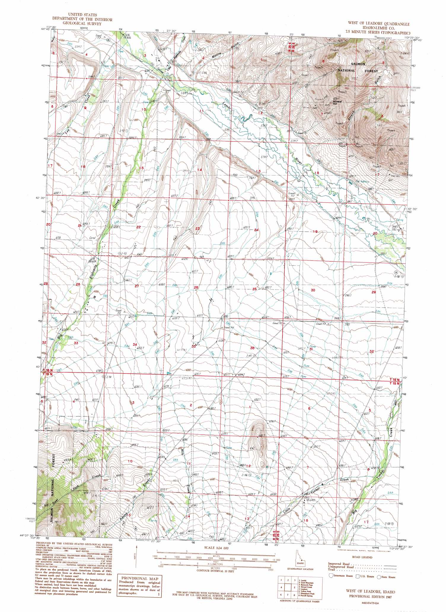
USGS Topo Quad 44113f4 - 1:24,000 scale
| Topo Map Name: | West Of Leadore |
| USGS Topo Quad ID: | 44113f4 |
| Print Size: | ca. 21 1/4" wide x 27" high |
| Southeast Coordinates: | 44.625° N latitude / 113.375° W longitude |
| Map Center Coordinates: | 44.6875° N latitude / 113.4375° W longitude |
| U.S. State: | ID |
| Filename: | o44113f4.jpg |
| Download Map JPG Image: | West Of Leadore topo map 1:24,000 scale |
| Map Type: | Topographic |
| Topo Series: | 7.5´ |
| Map Scale: | 1:24,000 |
| Source of Map Images: | United States Geological Survey (USGS) |
| Alternate Map Versions: |
West of Leadore ID 1987, updated 1987 Download PDF Buy paper map West of Leadore ID 2011 Download PDF Buy paper map West of Leadore ID 2013 Download PDF Buy paper map |
| FStopo: | US Forest Service topo West of Leadore is available: Download FStopo PDF Download FStopo TIF |
1:24,000 Topo Quads surrounding West Of Leadore
Tendoy |
Agency Creek |
Lemhi Pass |
Everson Creek |
Jeff Davis Peak |
Hayden Creek |
Lemhi |
Goat Mountain |
Bannock Pass |
Deadman Pass |
Mogg Mountain |
Stroud Creek |
West Of Leadore |
Leadore |
Reservoir Creek |
Patterson |
Yellow Peak |
Sheephorn Peak |
Purcell Spring |
Powderhorn Gulch |
Donkey Hills Nw |
Big Creek Peak |
Iron Creek Point |
Gilmore |
Gilmore Summit |
> Back to 44113e1 at 1:100,000 scale
> Back to 44112a1 at 1:250,000 scale
> Back to U.S. Topo Maps home
West Of Leadore topo map: Gazetteer
West Of Leadore: Dams
Lemhi River Weir elevation 1750m 5741′West Of Leadore: Streams
Adams Creek elevation 2019m 6624′Big Eightmile Creek elevation 1733m 5685′
Deer Park Creek elevation 1963m 6440′
Lee Creek elevation 1746m 5728′
Little Eightmile Creek elevation 1733m 5685′
Little Timber Creek elevation 1899m 6230′
Milk Creek elevation 1957m 6420′
West Of Leadore: Summits
Mineral Hill elevation 2036m 6679′West Of Leadore: Valleys
Mollie Gulch elevation 1776m 5826′Stroud Gulch elevation 1774m 5820′
West Of Leadore digital topo map on disk
Buy this West Of Leadore topo map showing relief, roads, GPS coordinates and other geographical features, as a high-resolution digital map file on DVD: