Clayton Topo Map Idaho
To zoom in, hover over the map of Clayton
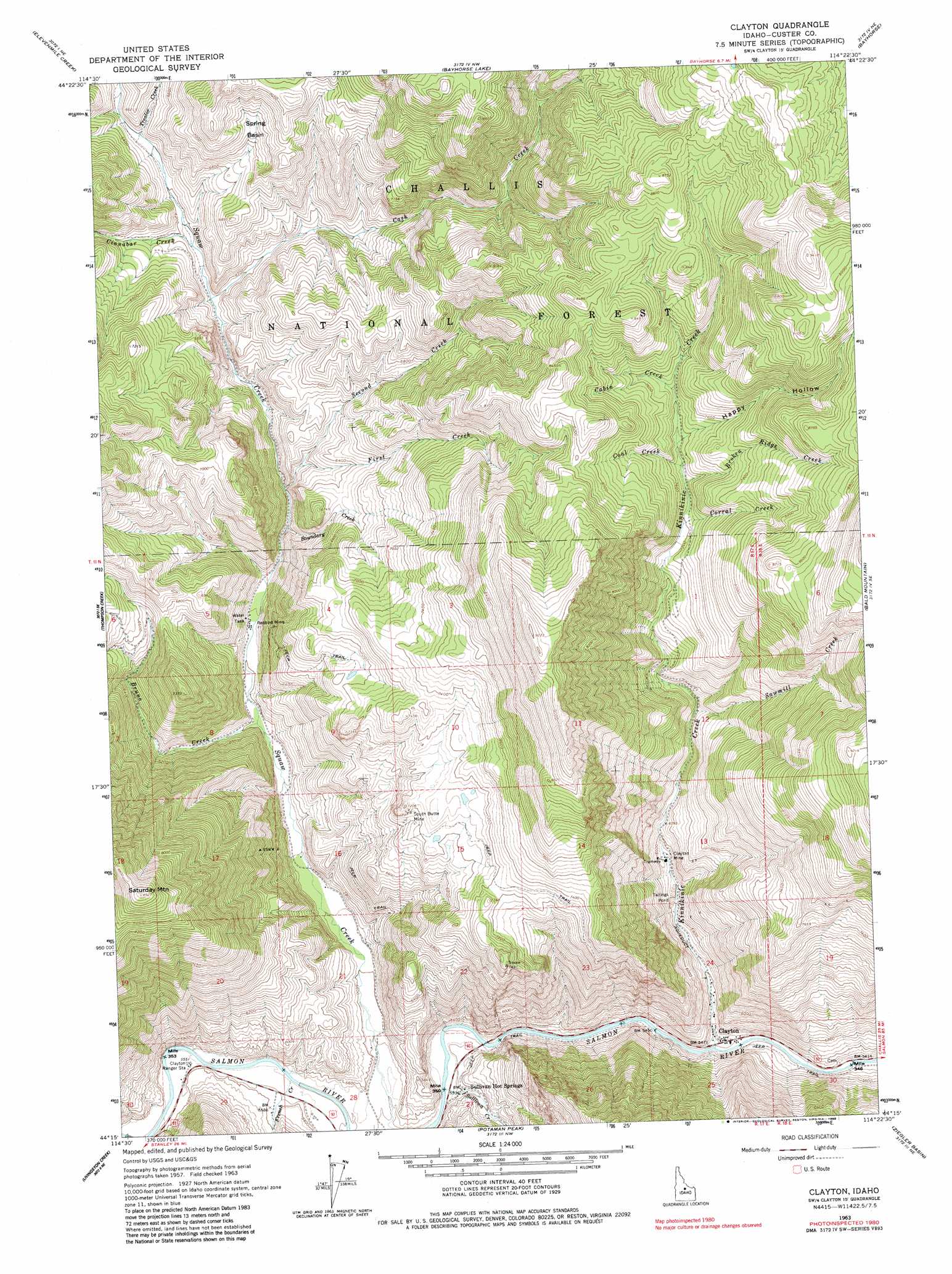
USGS Topo Quad 44114c4 - 1:24,000 scale
| Topo Map Name: | Clayton |
| USGS Topo Quad ID: | 44114c4 |
| Print Size: | ca. 21 1/4" wide x 27" high |
| Southeast Coordinates: | 44.25° N latitude / 114.375° W longitude |
| Map Center Coordinates: | 44.3125° N latitude / 114.4375° W longitude |
| U.S. State: | ID |
| Filename: | o44114c4.jpg |
| Download Map JPG Image: | Clayton topo map 1:24,000 scale |
| Map Type: | Topographic |
| Topo Series: | 7.5´ |
| Map Scale: | 1:24,000 |
| Source of Map Images: | United States Geological Survey (USGS) |
| Alternate Map Versions: |
Clayton ID 1963, updated 1964 Download PDF Buy paper map Clayton ID 1963, updated 1965 Download PDF Buy paper map Clayton ID 2011 Download PDF Buy paper map Clayton ID 2013 Download PDF Buy paper map |
| FStopo: | US Forest Service topo Clayton is available: Download FStopo PDF Download FStopo TIF |
1:24,000 Topo Quads surrounding Clayton
Sherman Peak |
Challis Creek Lakes |
Twin Peaks |
Pats Creek |
Challis |
Custer |
Elevenmile Creek |
Bayhorse Lake |
Bayhorse |
Bradbury Flat |
Sunbeam |
Thompson Creek |
Clayton |
Bald Mountain |
Lone Pine Peak |
Robinson Bar |
Livingston Creek |
Potaman Peak |
Ziegler Basin |
The Paint Pot |
Washington Peak |
Boulder Chain Lakes |
Bowery Creek |
Bowery Peak |
Herd Lake |
> Back to 44114a1 at 1:100,000 scale
> Back to 44114a1 at 1:250,000 scale
> Back to U.S. Topo Maps home
Clayton topo map: Gazetteer
Clayton: Basins
Spring Basin elevation 2103m 6899′Clayton: Dams
Clayton Mine Number One-Upper Dam elevation 1871m 6138′Clayton Mine Number Two-Lower Dam elevation 1901m 6236′
Clayton: Mines
Clayton Mine elevation 1814m 5951′Redbird Mine elevation 1790m 5872′
South Butte Mine elevation 2140m 7020′
Clayton: Populated Places
Clayton elevation 1665m 5462′Clayton: Springs
Sullivan Hot Springs elevation 1704m 5590′Clayton: Streams
Boundary Creek elevation 1804m 5918′Broken Ridge Creek elevation 2229m 7312′
Bruno Creek elevation 1759m 5770′
Cabin Creek elevation 2268m 7440′
Cash Creek elevation 1861m 6105′
Cinnabar Creek elevation 1873m 6145′
Coal Creek elevation 2219m 7280′
Corral Creek elevation 2194m 7198′
First Creek elevation 1816m 5958′
French Creek elevation 1684m 5524′
Kinnikinic Creek elevation 1660m 5446′
Sawmill Creek elevation 1941m 6368′
Second Creek elevation 1878m 6161′
Sullivan Creek elevation 1673m 5488′
Trandsfer Creek elevation 2299m 7542′
Trealor Creek elevation 1909m 6263′
Clayton: Summits
Saturday Mountain elevation 2725m 8940′Clayton: Valleys
Happy Hollow elevation 2248m 7375′Clayton digital topo map on disk
Buy this Clayton topo map showing relief, roads, GPS coordinates and other geographical features, as a high-resolution digital map file on DVD: