East Basin Creek Topo Map Idaho
To zoom in, hover over the map of East Basin Creek
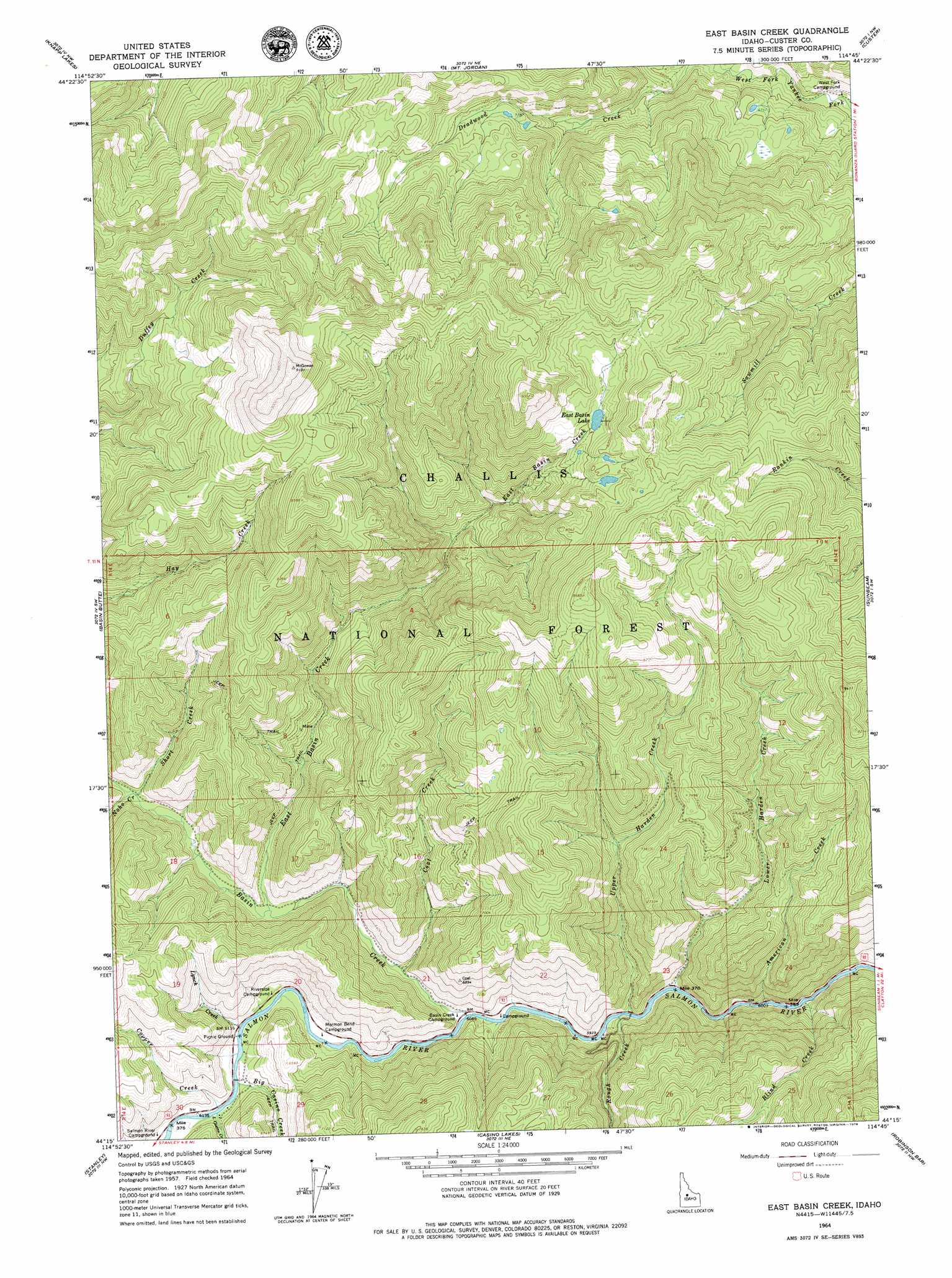
USGS Topo Quad 44114c7 - 1:24,000 scale
| Topo Map Name: | East Basin Creek |
| USGS Topo Quad ID: | 44114c7 |
| Print Size: | ca. 21 1/4" wide x 27" high |
| Southeast Coordinates: | 44.25° N latitude / 114.75° W longitude |
| Map Center Coordinates: | 44.3125° N latitude / 114.8125° W longitude |
| U.S. State: | ID |
| Filename: | o44114c7.jpg |
| Download Map JPG Image: | East Basin Creek topo map 1:24,000 scale |
| Map Type: | Topographic |
| Topo Series: | 7.5´ |
| Map Scale: | 1:24,000 |
| Source of Map Images: | United States Geological Survey (USGS) |
| Alternate Map Versions: |
East Basin Creek ID 1964, updated 1965 Download PDF Buy paper map East Basin Creek ID 1964, updated 1979 Download PDF Buy paper map East Basin Creek ID 2011 Download PDF Buy paper map East Basin Creek ID 2013 Download PDF Buy paper map |
| FStopo: | US Forest Service topo East Basin Creek is available: Download FStopo PDF Download FStopo TIF |
1:24,000 Topo Quads surrounding East Basin Creek
Greyhound Mountain |
Pinyon Peak |
Casto |
Sherman Peak |
Challis Creek Lakes |
Langer Peak |
Knapp Lakes |
Mount Jordan |
Custer |
Elevenmile Creek |
Elk Meadow |
Basin Butte |
East Basin Creek |
Sunbeam |
Thompson Creek |
Stanley Lake |
Stanley |
Casino Lakes |
Robinson Bar |
Livingston Creek |
Warbonnet Peak |
Mount Cramer |
Obsidian |
Washington Peak |
Boulder Chain Lakes |
> Back to 44114a1 at 1:100,000 scale
> Back to 44114a1 at 1:250,000 scale
> Back to U.S. Topo Maps home
East Basin Creek topo map: Gazetteer
East Basin Creek: Bends
Mormon Bend elevation 1862m 6108′East Basin Creek: Forests
Challis National Forest elevation 2588m 8490′East Basin Creek: Lakes
East Basin Lake elevation 2445m 8021′East Basin Creek: Streams
American Creek elevation 1823m 5980′Basin Creek elevation 1850m 6069′
Big Casino Creek elevation 1864m 6115′
Blind Creek elevation 1828m 5997′
Coal Creek elevation 1861m 6105′
Copper Creek elevation 1865m 6118′
East Basin Creek elevation 1895m 6217′
Little Casino Creek elevation 1865m 6118′
Lower Harden Creek elevation 1833m 6013′
Lynch Creek elevation 1863m 6112′
Noho Creek elevation 1934m 6345′
Short Creek elevation 1932m 6338′
Upper Harden Creek elevation 1836m 6023′
East Basin Creek digital topo map on disk
Buy this East Basin Creek topo map showing relief, roads, GPS coordinates and other geographical features, as a high-resolution digital map file on DVD: