Eagle Nest Topo Map Idaho
To zoom in, hover over the map of Eagle Nest
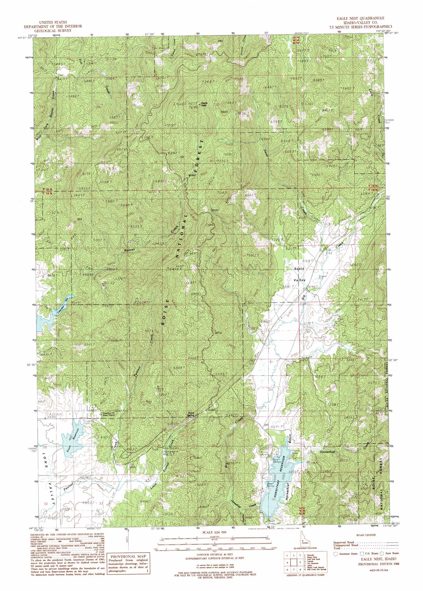
USGS Topo Quad 44115e8 - 1:24,000 scale
| Topo Map Name: | Eagle Nest |
| USGS Topo Quad ID: | 44115e8 |
| Print Size: | ca. 21 1/4" wide x 27" high |
| Southeast Coordinates: | 44.5° N latitude / 115.875° W longitude |
| Map Center Coordinates: | 44.5625° N latitude / 115.9375° W longitude |
| U.S. State: | ID |
| Filename: | o44115e8.jpg |
| Download Map JPG Image: | Eagle Nest topo map 1:24,000 scale |
| Map Type: | Topographic |
| Topo Series: | 7.5´ |
| Map Scale: | 1:24,000 |
| Source of Map Images: | United States Geological Survey (USGS) |
| Alternate Map Versions: |
Eagle Nest ID 1988, updated 1988 Download PDF Buy paper map Eagle Nest ID 2011 Download PDF Buy paper map Eagle Nest ID 2013 Download PDF Buy paper map |
| FStopo: | US Forest Service topo Eagle Nest is available: Download FStopo PDF Download FStopo TIF |
1:24,000 Topo Quads surrounding Eagle Nest
No Business Mountain |
Lake Fork |
Paddy Flat |
Blackmare |
White Rock Peak |
Lone Tree |
Donnelly |
Sloans Point |
Gold Fork Rock |
Warm Lake |
Cold Spring Ridge |
Cascade |
Eagle Nest |
Oro Mountain |
Rice Peak |
Tripod Peak |
Alpha |
Skunk Creek Summit |
Bull Creek Hot Springs |
Wild Buck Peak |
Sage Hen Reservoir |
Smiths Ferry |
Sixmile Point |
Boiling Springs |
Deadwood Reservoir |
> Back to 44115e1 at 1:100,000 scale
> Back to 44114a1 at 1:250,000 scale
> Back to U.S. Topo Maps home
Eagle Nest topo map: Gazetteer
Eagle Nest: Basins
Horsethief Basin elevation 1541m 5055′Scott Valley elevation 1573m 5160′
Eagle Nest: Dams
Callender Dam elevation 1483m 4865′Davis Dam elevation 1467m 4812′
Horsethief Basin Dam elevation 1541m 5055′
Eagle Nest: Parks
Horsethief Reservoir State Park elevation 1541m 5055′Eagle Nest: Populated Places
Eagle Nest elevation 2315m 7595′Eagle Nest: Reservoirs
Calendar Reservoir elevation 1483m 4865′Davis Reservoir elevation 1467m 4812′
Horsethief Reservoir elevation 1541m 5055′
Eagle Nest: Streams
Deep Creek elevation 1572m 5157′Horsethief Creek elevation 1518m 4980′
Little Horsethief Creek elevation 1521m 4990′
Little Pearsol Creek elevation 1467m 4812′
Eagle Nest: Trails
Eagle Nest Trail elevation 2077m 6814′Eagle Nest digital topo map on disk
Buy this Eagle Nest topo map showing relief, roads, GPS coordinates and other geographical features, as a high-resolution digital map file on DVD: