Big Baldy Topo Map Idaho
To zoom in, hover over the map of Big Baldy
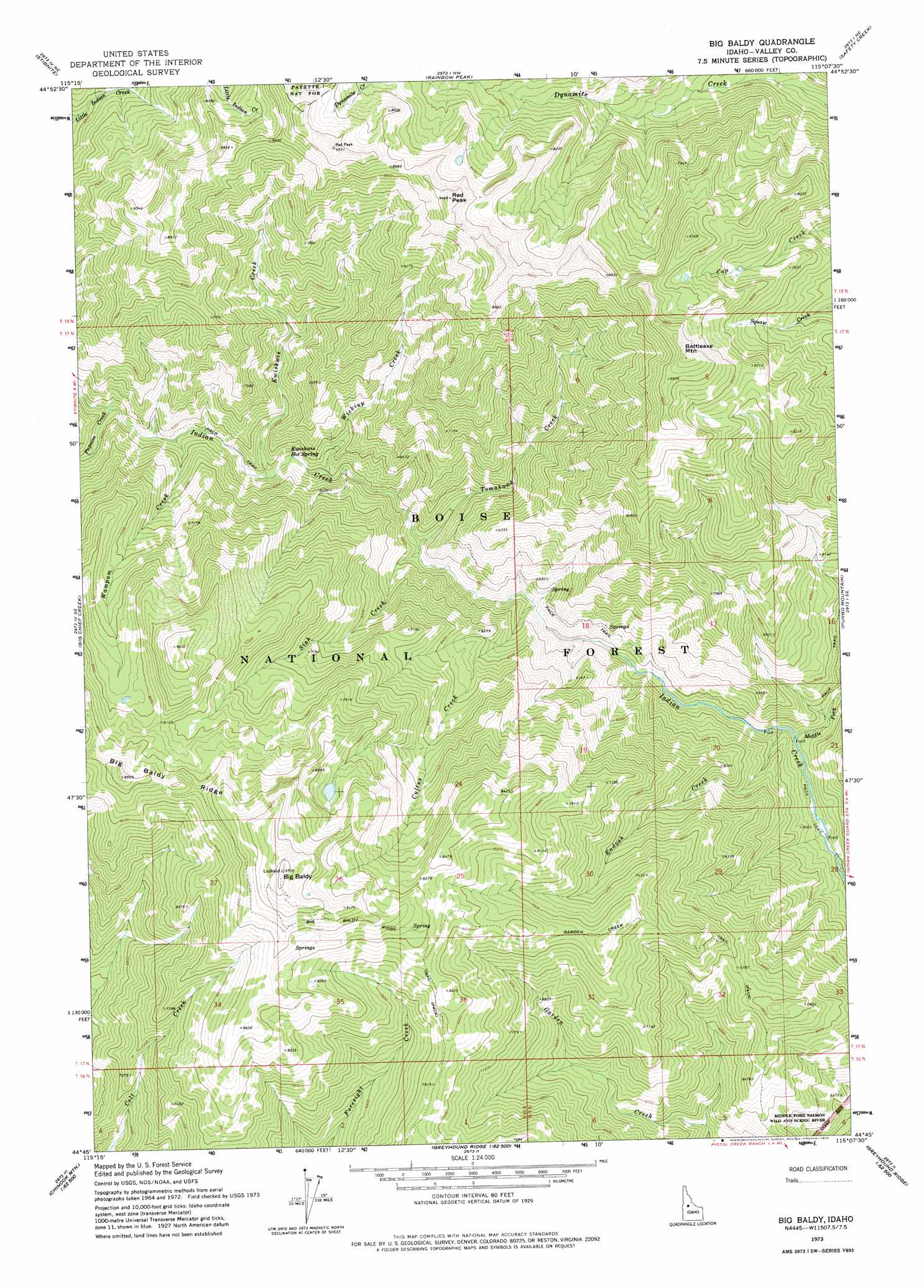
USGS Topo Quad 44115g2 - 1:24,000 scale
| Topo Map Name: | Big Baldy |
| USGS Topo Quad ID: | 44115g2 |
| Print Size: | ca. 21 1/4" wide x 27" high |
| Southeast Coordinates: | 44.75° N latitude / 115.125° W longitude |
| Map Center Coordinates: | 44.8125° N latitude / 115.1875° W longitude |
| U.S. State: | ID |
| Filename: | o44115g2.jpg |
| Download Map JPG Image: | Big Baldy topo map 1:24,000 scale |
| Map Type: | Topographic |
| Topo Series: | 7.5´ |
| Map Scale: | 1:24,000 |
| Source of Map Images: | United States Geological Survey (USGS) |
| Alternate Map Versions: |
Big Baldy ID 1973, updated 1975 Download PDF Buy paper map Big Baldy ID 2011 Download PDF Buy paper map Big Baldy ID 2013 Download PDF Buy paper map |
| FStopo: | US Forest Service topo Big Baldy is available: Download FStopo PDF Download FStopo TIF |
1:24,000 Topo Quads surrounding Big Baldy
Profile Gap |
Edwardsburg |
Center Mountain |
Monument |
Mormon Mountain |
Yellow Pine |
Stibnite |
Rainbow Peak |
Safety Creek |
Shellrock Peak |
Chilcoot Peak |
Big Chief Creek |
Big Baldy |
Pungo Mountain |
Norton Ridge |
Pistol Lake |
Chinook Mountain |
Artillery Dome |
Little Soldier Mountain |
Sliderock Ridge |
Honeymoon Lake |
Big Soldier Mountain |
Soldier Creek |
Greyhound Mountain |
Pinyon Peak |
> Back to 44115e1 at 1:100,000 scale
> Back to 44114a1 at 1:250,000 scale
> Back to U.S. Topo Maps home
Big Baldy topo map: Gazetteer
Big Baldy: Springs
Kwiskwis Hot Spring elevation 1741m 5711′Big Baldy: Streams
Cultus Creek elevation 1607m 5272′Endoah Creek elevation 1511m 4957′
Kwiskwis Creek elevation 1725m 5659′
Middle Fork Indian Creek elevation 1502m 4927′
Papoose Creek elevation 1783m 5849′
Siah Creek elevation 1657m 5436′
Tomahawk Creek elevation 1653m 5423′
Wampum Creek elevation 1778m 5833′
Wickiup Creek elevation 1706m 5597′
Big Baldy: Summits
Battleaxe Mountain elevation 2804m 9199′Big Baldy elevation 2951m 9681′
Red Peak elevation 2880m 9448′
Big Baldy: Trails
Big Baldy Ridge Trail elevation 2534m 8313′Garden Creek Trail elevation 2268m 7440′
Big Baldy digital topo map on disk
Buy this Big Baldy topo map showing relief, roads, GPS coordinates and other geographical features, as a high-resolution digital map file on DVD: