Coonrod Gulch Topo Map Idaho
To zoom in, hover over the map of Coonrod Gulch
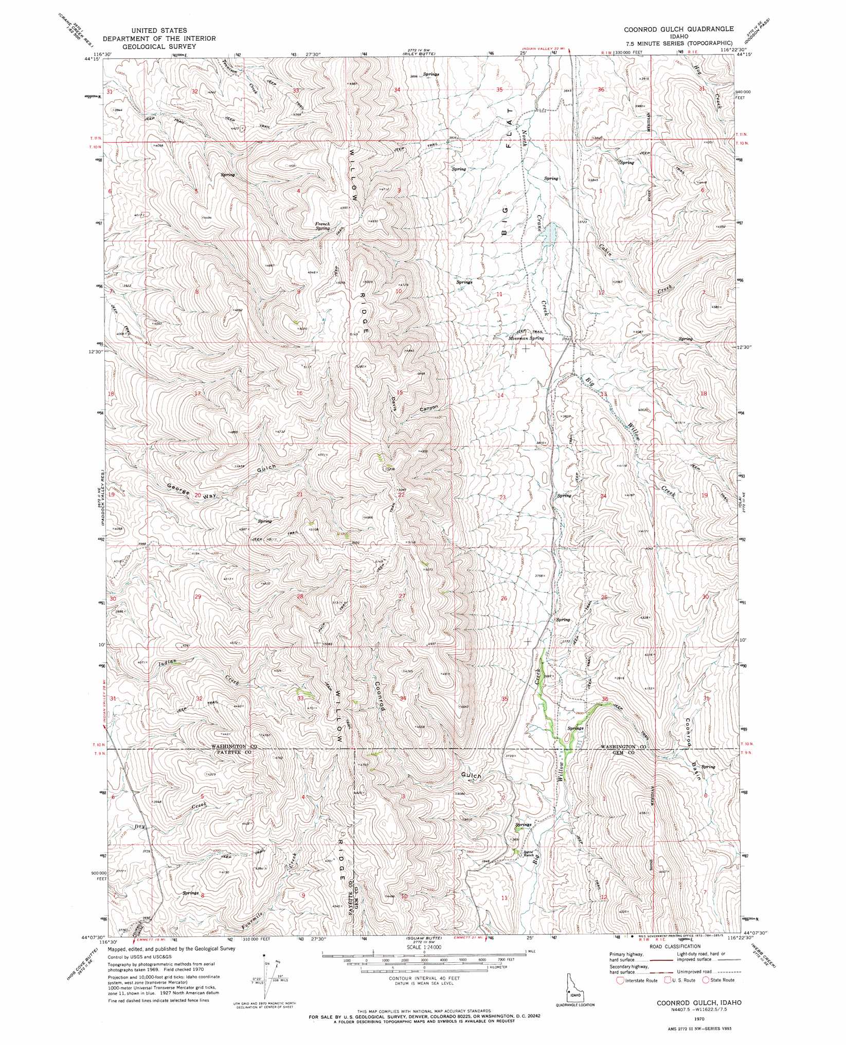
USGS Topo Quad 44116b4 - 1:24,000 scale
| Topo Map Name: | Coonrod Gulch |
| USGS Topo Quad ID: | 44116b4 |
| Print Size: | ca. 21 1/4" wide x 27" high |
| Southeast Coordinates: | 44.125° N latitude / 116.375° W longitude |
| Map Center Coordinates: | 44.1875° N latitude / 116.4375° W longitude |
| U.S. State: | ID |
| Filename: | o44116b4.jpg |
| Download Map JPG Image: | Coonrod Gulch topo map 1:24,000 scale |
| Map Type: | Topographic |
| Topo Series: | 7.5´ |
| Map Scale: | 1:24,000 |
| Source of Map Images: | United States Geological Survey (USGS) |
| Alternate Map Versions: |
Coonrod Gulch ID 1970, updated 1973 Download PDF Buy paper map Coonrod Gulch ID 2010 Download PDF Buy paper map Coonrod Gulch ID 2013 Download PDF Buy paper map |
1:24,000 Topo Quads surrounding Coonrod Gulch
Midvale |
Hog Creek Butte |
Granger Butte |
Twin Sisters |
Tripod Peak |
Nutmeg Flat |
Crane Creek Reservoir |
Riley Butte |
Dodson Pass |
Sage Hen Reservoir |
Holland Gulch |
Paddock Valley Reservoir |
Coonrod Gulch |
Ola |
High Valley |
Sheep Ridge |
Hog Cove Butte |
Squaw Butte |
Webb Creek |
Dry Buck Valley |
Letha |
Northwest Emmett |
Northeast Emmett |
Montour |
Horseshoe Bend |
> Back to 44116a1 at 1:100,000 scale
> Back to 44116a1 at 1:250,000 scale
> Back to U.S. Topo Maps home
Coonrod Gulch topo map: Gazetteer
Coonrod Gulch: Basins
Coonrod Basin elevation 1164m 3818′Coonrod Gulch: Dams
Little Dam elevation 1123m 3684′Coonrod Gulch: Ridges
Willow Ridge elevation 1602m 5255′Coonrod Gulch: Springs
French Spring elevation 1462m 4796′Mossman Spring elevation 1153m 3782′
Coonrod Gulch: Streams
Cabin Creek elevation 1113m 3651′Coonrod Gulch: Valleys
Coonrod Gulch elevation 1075m 3526′Davis Canyon elevation 1256m 4120′
Coonrod Gulch digital topo map on disk
Buy this Coonrod Gulch topo map showing relief, roads, GPS coordinates and other geographical features, as a high-resolution digital map file on DVD: