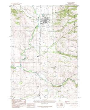
Council Topo Map Idaho
To zoom in, hover over the map of Council
USGS Topo Quad 44116f4 - 1:24,000 scale
| Topo Map Name: | Council |
| USGS Topo Quad ID: | 44116f4 |
| Print Size: | ca. 21 1/4" wide x 27" high |
| Southeast Coordinates: | 44.625° N latitude / 116.375° W longitude |
| Map Center Coordinates: | 44.6875° N latitude / 116.4375° W longitude |
| U.S. State: | ID |
| Filename: | o44116f4.jpg |
| Download Map JPG Image: | Council topo map 1:24,000 scale |
| Map Type: | Topographic |
| Topo Series: | 7.5´ |
| Map Scale: | 1:24,000 |
| Source of Map Images: | United States Geological Survey (USGS) |
| Alternate Map Versions: |
Council ID 1986, updated 1986 Download PDF Buy paper map Council ID 2004, updated 2007 Download PDF Buy paper map Council ID 2011 Download PDF Buy paper map Council ID 2013 Download PDF Buy paper map |
| FStopo: | US Forest Service topo Council is available: Download FStopo PDF Download FStopo TIF |
1:24,000 Topo Quads surrounding Council
> Back to 44116e1 at 1:100,000 scale
> Back to 44116a1 at 1:250,000 scale
> Back to U.S. Topo Maps home
Council topo map: Gazetteer
Council: Lakes
Leeks Pond elevation 943m 3093′Council: Populated Places
Council elevation 892m 2926′Mesa elevation 991m 3251′
Council: Streams
Cool Creek elevation 899m 2949′Cottonwood Creek elevation 874m 2867′
Hornet Creek elevation 884m 2900′
Lester Creek elevation 878m 2880′
Middle Fork Weiser River elevation 867m 2844′
School Creek elevation 895m 2936′
Council: Valleys
Grossen Canyon elevation 951m 3120′Long Gulch elevation 961m 3152′
Council digital topo map on disk
Buy this Council topo map showing relief, roads, GPS coordinates and other geographical features, as a high-resolution digital map file on DVD:


