Crooked River Point Topo Map Idaho
To zoom in, hover over the map of Crooked River Point
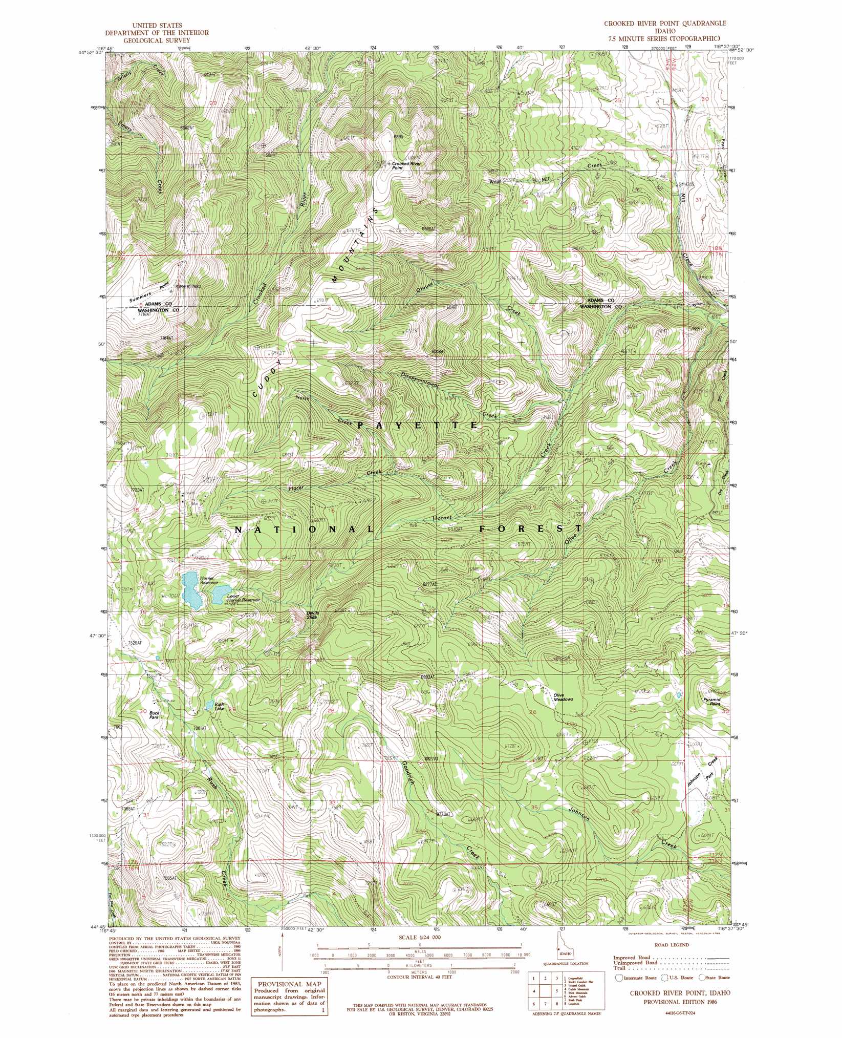
USGS Topo Quad 44116g6 - 1:24,000 scale
| Topo Map Name: | Crooked River Point |
| USGS Topo Quad ID: | 44116g6 |
| Print Size: | ca. 21 1/4" wide x 27" high |
| Southeast Coordinates: | 44.75° N latitude / 116.625° W longitude |
| Map Center Coordinates: | 44.8125° N latitude / 116.6875° W longitude |
| U.S. State: | ID |
| Filename: | o44116g6.jpg |
| Download Map JPG Image: | Crooked River Point topo map 1:24,000 scale |
| Map Type: | Topographic |
| Topo Series: | 7.5´ |
| Map Scale: | 1:24,000 |
| Source of Map Images: | United States Geological Survey (USGS) |
| Alternate Map Versions: |
Crooked River Point ID 1986, updated 1986 Download PDF Buy paper map Crooked River Point ID 2004, updated 2007 Download PDF Buy paper map Crooked River Point ID 2011 Download PDF Buy paper map Crooked River Point ID 2013 Download PDF Buy paper map |
| FStopo: | US Forest Service topo Crooked River Point is available: Download FStopo PDF Download FStopo TIF |
1:24,000 Topo Quads surrounding Crooked River Point
Duck Creek |
Homestead |
Cuprum |
Butterfield Gulch |
Railroad Saddle |
Mclain Gulch |
Oxbow |
Rocky Comfort Flat |
Weasel Gulch |
Tamarack |
Brownlee Dam |
Cuddy Mountain |
Crooked River Point |
Peck Mountain |
Fruitvale |
Neil Gulch |
Advent Gulch |
Rush Peak |
Goodrich |
Council |
Sturgill Peak |
Hopper Creek |
Cambridge |
East Of Cambridge |
Indian Valley |
> Back to 44116e1 at 1:100,000 scale
> Back to 44116a1 at 1:250,000 scale
> Back to U.S. Topo Maps home
Crooked River Point topo map: Gazetteer
Crooked River Point: Cliffs
Devils Slide elevation 2031m 6663′Crooked River Point: Dams
Hornet Creek-Lower Dam elevation 2101m 6893′Hornet Creek-Upper Dam elevation 2154m 7066′
Crooked River Point: Flats
Olive Meadows elevation 1945m 6381′Crooked River Point: Lakes
Rush Lake elevation 2180m 7152′Crooked River Point: Mines
Cuddy Mine elevation 2215m 7267′Crooked River Point: Ranges
Cuddy Mountains elevation 2306m 7565′Crooked River Point: Reservoirs
Hornet Reservoir elevation 2154m 7066′Lower Hornet Reservoir elevation 2101m 6893′
Crooked River Point: Ridges
Summers Point elevation 2348m 7703′Crooked River Point: Streams
Grouse Creek elevation 1377m 4517′North Creek elevation 1753m 5751′
Olive Creek elevation 1229m 4032′
Placer Creek elevation 1600m 5249′
West Mill Creek elevation 1300m 4265′
Crooked River Point: Summits
Crooked River Point elevation 2107m 6912′Pyramid Point elevation 1983m 6505′
Crooked River Point digital topo map on disk
Buy this Crooked River Point topo map showing relief, roads, GPS coordinates and other geographical features, as a high-resolution digital map file on DVD: