Meadows Topo Map Idaho
To zoom in, hover over the map of Meadows
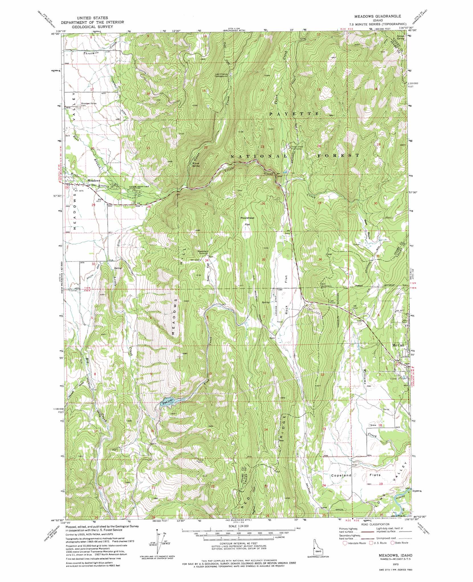
USGS Topo Quad 44116h2 - 1:24,000 scale
| Topo Map Name: | Meadows |
| USGS Topo Quad ID: | 44116h2 |
| Print Size: | ca. 21 1/4" wide x 27" high |
| Southeast Coordinates: | 44.875° N latitude / 116.125° W longitude |
| Map Center Coordinates: | 44.9375° N latitude / 116.1875° W longitude |
| U.S. State: | ID |
| Filename: | o44116h2.jpg |
| Download Map JPG Image: | Meadows topo map 1:24,000 scale |
| Map Type: | Topographic |
| Topo Series: | 7.5´ |
| Map Scale: | 1:24,000 |
| Source of Map Images: | United States Geological Survey (USGS) |
| Alternate Map Versions: |
Meadows ID 1973, updated 1976 Download PDF Buy paper map Meadows ID 1973, updated 1976 Download PDF Buy paper map Meadows ID 2004, updated 2007 Download PDF Buy paper map Meadows ID 2011 Download PDF Buy paper map Meadows ID 2013 Download PDF Buy paper map |
| FStopo: | US Forest Service topo Meadows is available: Download FStopo PDF Download FStopo TIF |
1:24,000 Topo Quads surrounding Meadows
Pollock Mountain |
Indian Mountain |
Hazard Lake |
Black Tip |
Victor Peak |
Railroad Saddle |
Bally Mountain |
Brundage Mountain |
Granite Lake |
Box Lake |
Tamarack |
New Meadows |
Meadows |
Mccall |
Fitsum Summit |
Fruitvale |
Cold Spring Summit |
No Business Mountain |
Lake Fork |
Paddy Flat |
Council |
Council Mountain |
Lone Tree |
Donnelly |
Sloans Point |
> Back to 44116e1 at 1:100,000 scale
> Back to 44116a1 at 1:250,000 scale
> Back to U.S. Topo Maps home
Meadows topo map: Gazetteer
Meadows: Basins
Bear Basin elevation 1637m 5370′Meadows: Canals
South End Ditch elevation 1232m 4041′Meadows: Dams
Hancock Dam elevation 1423m 4668′Payette Lake Dam elevation 1536m 5039′
Meadows: Flats
Copeland Flats elevation 1525m 5003′Ecks Flat elevation 1533m 5029′
Moorehead Flat elevation 1567m 5141′
Rock Flat elevation 1562m 5124′
Meadows: Parks
Packer Johns Cabin State Park elevation 1239m 4064′Meadows: Populated Places
Meadows elevation 1212m 3976′Meadows: Reservoirs
Fish Lake elevation 1423m 4668′Payette Lake elevation 1536m 5039′
Meadows: Springs
Warm Spring elevation 1309m 4294′Meadows: Streams
Fish Creek elevation 1351m 4432′Goose Creek elevation 1246m 4087′
Little Goose Creek elevation 1297m 4255′
Thorn Creek elevation 1506m 4940′
Thrush Creek elevation 1256m 4120′
Trail Creek elevation 1415m 4642′
Meadows: Summits
Meadow Hill elevation 1611m 5285′Meadows Summit elevation 1562m 5124′
Meadows digital topo map on disk
Buy this Meadows topo map showing relief, roads, GPS coordinates and other geographical features, as a high-resolution digital map file on DVD: