Tub Mountain Topo Map Oregon
To zoom in, hover over the map of Tub Mountain
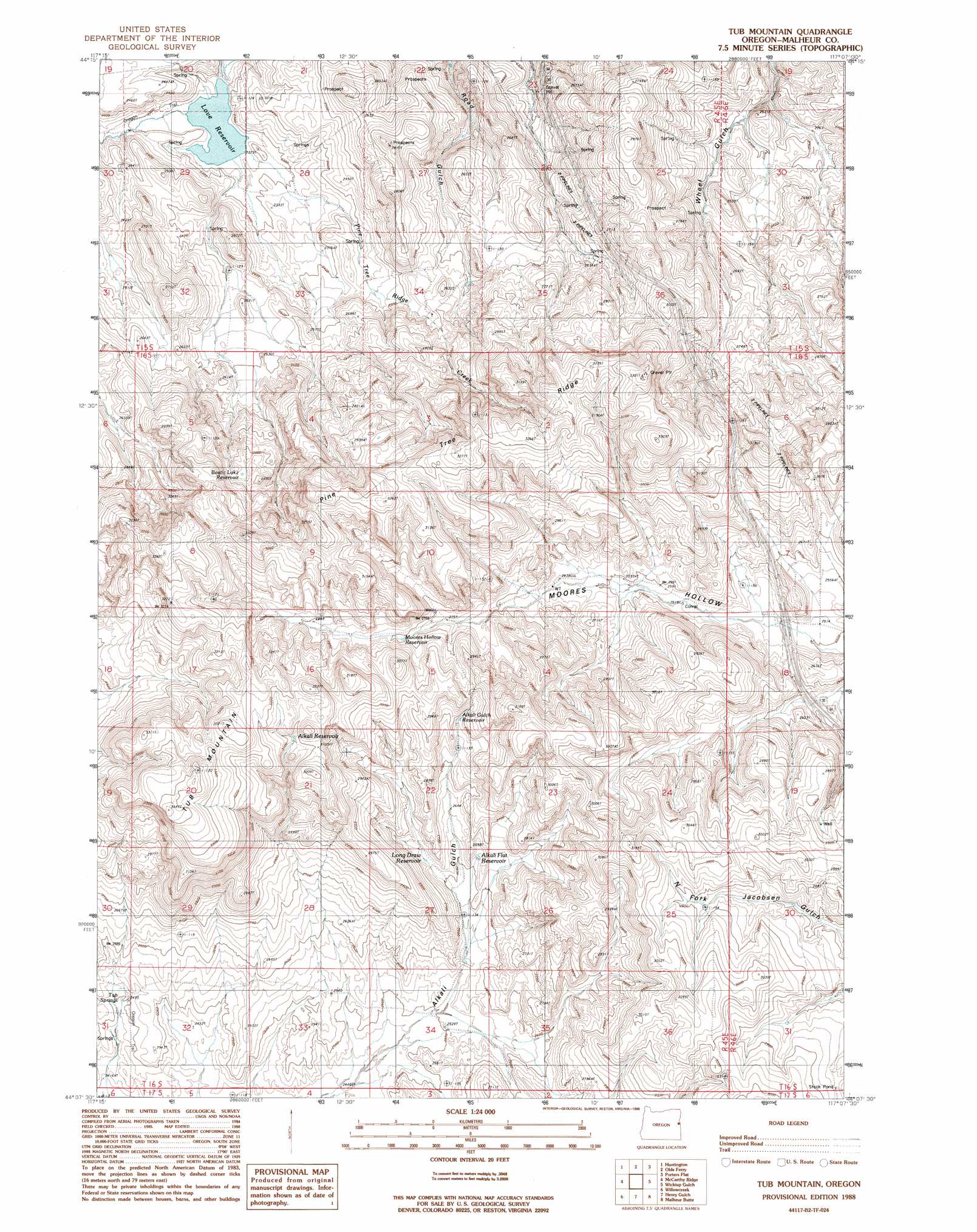
USGS Topo Quad 44117b2 - 1:24,000 scale
| Topo Map Name: | Tub Mountain |
| USGS Topo Quad ID: | 44117b2 |
| Print Size: | ca. 21 1/4" wide x 27" high |
| Southeast Coordinates: | 44.125° N latitude / 117.125° W longitude |
| Map Center Coordinates: | 44.1875° N latitude / 117.1875° W longitude |
| U.S. State: | OR |
| Filename: | o44117b2.jpg |
| Download Map JPG Image: | Tub Mountain topo map 1:24,000 scale |
| Map Type: | Topographic |
| Topo Series: | 7.5´ |
| Map Scale: | 1:24,000 |
| Source of Map Images: | United States Geological Survey (USGS) |
| Alternate Map Versions: |
Tub Mountain OR 1988, updated 1988 Download PDF Buy paper map Tub Mountain OR 2011 Download PDF Buy paper map Tub Mountain OR 2014 Download PDF Buy paper map |
1:24,000 Topo Quads surrounding Tub Mountain
Rye Valley |
Lime |
Henley Basin |
Olds Ferry Ne |
Mann Creek Nw |
Birch Creek Meadow |
Huntington |
Olds Ferry |
Porters Flat |
Weiser North |
Jamieson |
Mccarthy Ridge |
Tub Mountain |
Moores Hollow |
Weiser South |
Hope Butte |
Willow Creek |
Henry Gulch |
Malheur Butte |
Payette |
Vines Hill |
Vale West |
Vale East |
Cairo |
Nyssa |
> Back to 44117a1 at 1:100,000 scale
> Back to 44116a1 at 1:250,000 scale
> Back to U.S. Topo Maps home
Tub Mountain topo map: Gazetteer
Tub Mountain: Basins
Wheel Gulch Basin elevation 709m 2326′Tub Mountain: Dams
Moores Hollow Dam elevation 854m 2801′Tub Mountain: Reservoirs
Alkali Flat Reservoir elevation 799m 2621′Alkali Gulch Reservoir elevation 846m 2775′
Alkali Reservoir elevation 939m 3080′
Bostic Lake Reservoir elevation 865m 2837′
Long Drain Reservoir elevation 802m 2631′
Love Reservoir elevation 693m 2273′
Moores Hollow Reservoir elevation 854m 2801′
Tub Mountain: Ridges
Pine Tree Ridge elevation 981m 3218′Tub Mountain: Springs
Tub Springs elevation 762m 2500′Tub Mountain: Streams
Pine Tree Ridge Creek elevation 693m 2273′Tub Mountain: Summits
Tub Mountain elevation 1049m 3441′Tub Mountain: Valleys
Trail Gulch elevation 791m 2595′Tub Mountain digital topo map on disk
Buy this Tub Mountain topo map showing relief, roads, GPS coordinates and other geographical features, as a high-resolution digital map file on DVD: