Cow Valley East Topo Map Oregon
To zoom in, hover over the map of Cow Valley East
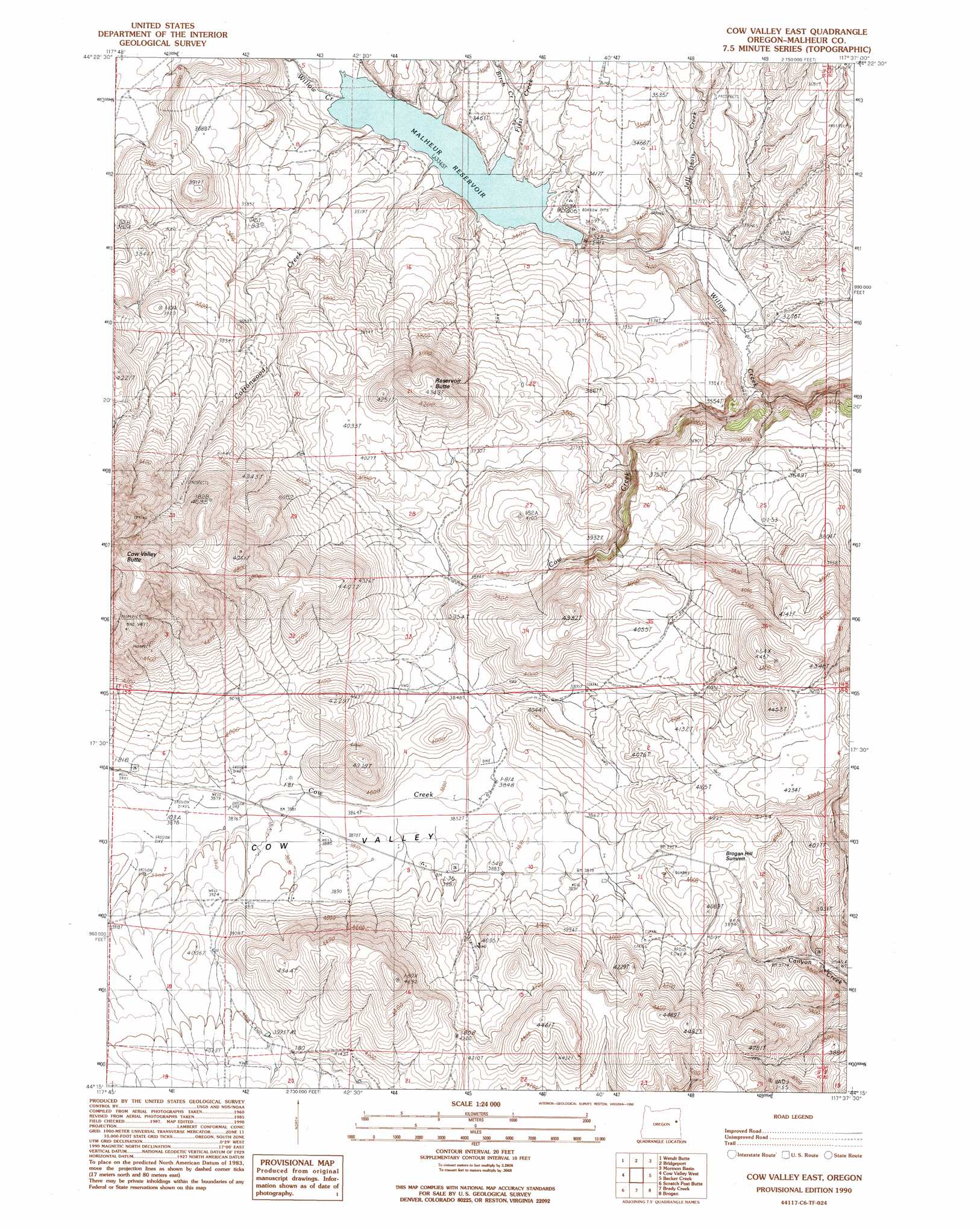
USGS Topo Quad 44117c6 - 1:24,000 scale
| Topo Map Name: | Cow Valley East |
| USGS Topo Quad ID: | 44117c6 |
| Print Size: | ca. 21 1/4" wide x 27" high |
| Southeast Coordinates: | 44.25° N latitude / 117.625° W longitude |
| Map Center Coordinates: | 44.3125° N latitude / 117.6875° W longitude |
| U.S. State: | OR |
| Filename: | o44117c6.jpg |
| Download Map JPG Image: | Cow Valley East topo map 1:24,000 scale |
| Map Type: | Topographic |
| Topo Series: | 7.5´ |
| Map Scale: | 1:24,000 |
| Source of Map Images: | United States Geological Survey (USGS) |
| Alternate Map Versions: |
Cow Valley East OR 1990, updated 1990 Download PDF Buy paper map Cow Valley East OR 2011 Download PDF Buy paper map Cow Valley East OR 2014 Download PDF Buy paper map |
1:24,000 Topo Quads surrounding Cow Valley East
Brannan Gulch |
Dooley Mountain |
French Gulch |
Lost Basin |
Durkee |
Devils Heel |
Wendt Butte |
Bridgeport |
Mormon Basin |
Rye Valley |
Ironside |
Cow Valley West |
Cow Valley East |
Becker Creek |
Birch Creek Meadow |
Clover Creek Ranch |
Scratch Post Mountain |
Juniper Mountain |
Brogan |
Jamieson |
Little Juniper Spring |
Log Creek |
Buckbrush Creek |
Swede Flat |
Hope Butte |
> Back to 44117a1 at 1:100,000 scale
> Back to 44116a1 at 1:250,000 scale
> Back to U.S. Topo Maps home
Cow Valley East topo map: Gazetteer
Cow Valley East: Canals
Beers Ditch elevation 1000m 3280′Cow Valley East: Dams
Malheur Dam elevation 1048m 3438′Cow Valley East: Gaps
Brogan Hill Summit elevation 1214m 3982′Cow Valley East: Reservoirs
Davis Reservoir Four elevation 1098m 3602′Malheur Reservoir elevation 1048m 3438′
Cow Valley East: Streams
Antelope Springs Creek elevation 1181m 3874′Birch Creek elevation 1041m 3415′
Cottonwood Creek elevation 1038m 3405′
Cow Creek elevation 977m 3205′
First Creek elevation 1027m 3369′
Jeff Davis Creek elevation 999m 3277′
Cow Valley East: Summits
Brogan Hill elevation 1244m 4081′Reservoir Butte elevation 1326m 4350′
Cow Valley East: Valleys
Cow Valley elevation 1220m 4002′Cow Valley East digital topo map on disk
Buy this Cow Valley East topo map showing relief, roads, GPS coordinates and other geographical features, as a high-resolution digital map file on DVD: