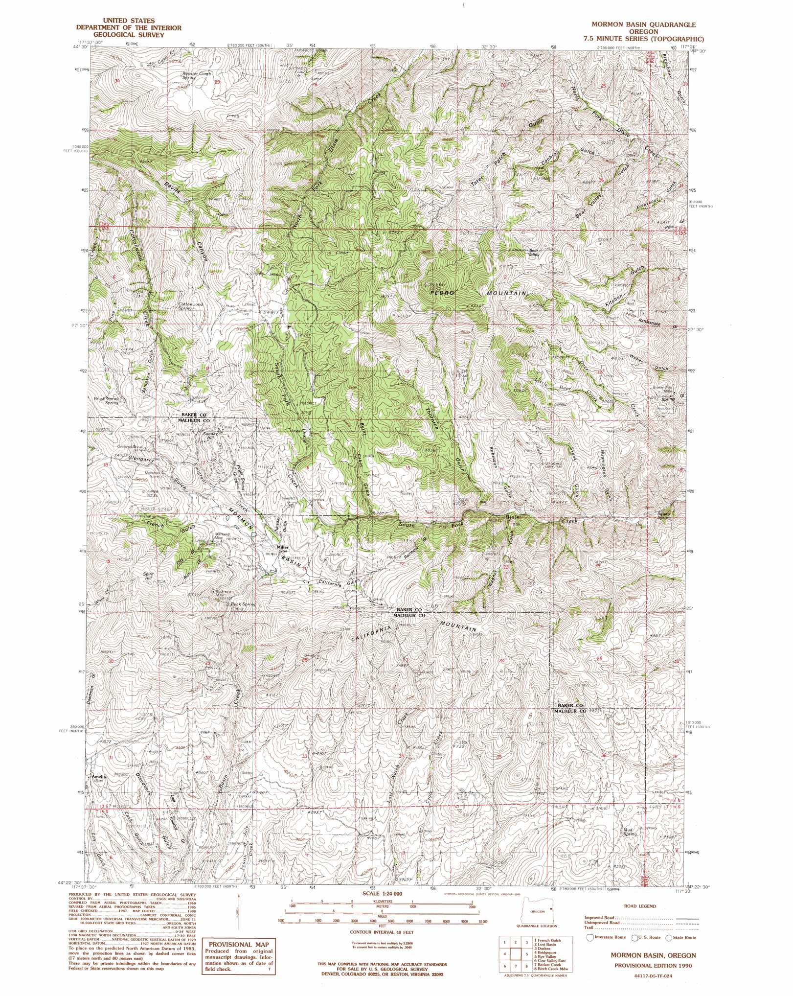
Mormon Basin Topo Map Oregon
To zoom in, hover over the map of Mormon Basin
USGS Topo Quad 44117d5 - 1:24,000 scale
| Topo Map Name: | Mormon Basin |
| USGS Topo Quad ID: | 44117d5 |
| Print Size: | ca. 21 1/4" wide x 27" high |
| Southeast Coordinates: | 44.375° N latitude / 117.5° W longitude |
| Map Center Coordinates: | 44.4375° N latitude / 117.5625° W longitude |
| U.S. State: | OR |
| Filename: | o44117d5.jpg |
| Download Map JPG Image: | Mormon Basin topo map 1:24,000 scale |
| Map Type: | Topographic |
| Topo Series: | 7.5´ |
| Map Scale: | 1:24,000 |
| Source of Map Images: | United States Geological Survey (USGS) |
| Alternate Map Versions: |
Mormon Basin OR 1990, updated 1990 Download PDF Buy paper map Mormon Basin OR 2011 Download PDF Buy paper map Mormon Basin OR 2014 Download PDF Buy paper map |
1:24,000 Topo Quads surrounding Mormon Basin
Bowen Valley |
Encina |
Oxman |
Lawrence Creek |
Little Lookout Mountain |
Dooley Mountain |
French Gulch |
Lost Basin |
Durkee |
Big Lookout Mountain |
Wendt Butte |
Bridgeport |
Mormon Basin |
Rye Valley |
Lime |
Cow Valley West |
Cow Valley East |
Becker Creek |
Birch Creek Meadow |
Huntington |
Scratch Post Mountain |
Juniper Mountain |
Brogan |
Jamieson |
Mccarthy Ridge |
> Back to 44117a1 at 1:100,000 scale
> Back to 44116a1 at 1:250,000 scale
> Back to U.S. Topo Maps home
Mormon Basin topo map: Gazetteer
Mormon Basin: Basins
Bear Valley elevation 1626m 5334′Mormon Basin elevation 1465m 4806′
Mormon Basin: Mines
Blue Mud Mine elevation 1566m 5137′Broken Pick Mine elevation 1299m 4261′
Buckhorn Mine elevation 1537m 5042′
Cleveland Mine elevation 1469m 4819′
Humboldt Mine elevation 1528m 5013′
Monohon Tunnel Mine elevation 1595m 5232′
Oregon Chief Mine elevation 1506m 4940′
Overshot Group Mine elevation 1630m 5347′
Rainbow Mine elevation 1590m 5216′
Summit Mine elevation 1565m 5134′
Mormon Basin: Populated Places
Cake (historical) elevation 1485m 4872′Humboldt Basin (historical) elevation 1530m 5019′
Mormon Basin: Post Offices
Basin Post Office (historical) elevation 1516m 4973′Cake Post Office (historical) elevation 1485m 4872′
Humboldt Basin Post Office (historical) elevation 1530m 5019′
Miller Post Office (historical) elevation 1462m 4796′
Pedro Post Office (historical) elevation 1665m 5462′
Rainbow Mine Post Office (historical) elevation 1533m 5029′
Mormon Basin: Springs
Brush Spray Spring elevation 1664m 5459′Cottonwood Spring elevation 1682m 5518′
Cube Spring elevation 1527m 5009′
Mattie Spring elevation 1636m 5367′
Mine Spring elevation 1661m 5449′
Mud Spring elevation 1362m 4468′
Rock Spring elevation 1398m 4586′
Rooster Comb Spring elevation 1751m 5744′
Squaw Spring elevation 1129m 3704′
Mormon Basin: Streams
Emigrant Creek elevation 1450m 4757′Little Deer Creek elevation 1406m 4612′
Pine Creek elevation 1366m 4481′
Mormon Basin: Summits
California Mountain elevation 1727m 5666′Spirit Hill elevation 1769m 5803′
Sunday Hill elevation 1624m 5328′
Mormon Basin: Valleys
Bear Valley Gulch elevation 1112m 3648′Burnt Cabin Gulch elevation 1440m 4724′
California Gulch elevation 1439m 4721′
City Gulch elevation 1463m 4799′
Cochran Gulch elevation 1125m 3690′
Devils Canyon elevation 1392m 4566′
Freezeout Gulch elevation 1086m 3562′
French Gulch elevation 1491m 4891′
Glengarry Gulch elevation 1505m 4937′
Last Chance Gulch elevation 1100m 3608′
Puget Sound Gulch elevation 1490m 4888′
Rainbow Gulch elevation 1413m 4635′
Rich Gulch elevation 1498m 4914′
Robinson Gulch elevation 1248m 4094′
Sampson Gulch elevation 1537m 5042′
Skunk Gulch elevation 1174m 3851′
Tater Patch Gulch elevation 1136m 3727′
Thornton Gulch elevation 1307m 4288′
Tuesday Gulch elevation 1574m 5164′
Wagner Gulch elevation 1285m 4215′
Washington Gulch elevation 1157m 3795′
Mormon Basin digital topo map on disk
Buy this Mormon Basin topo map showing relief, roads, GPS coordinates and other geographical features, as a high-resolution digital map file on DVD: