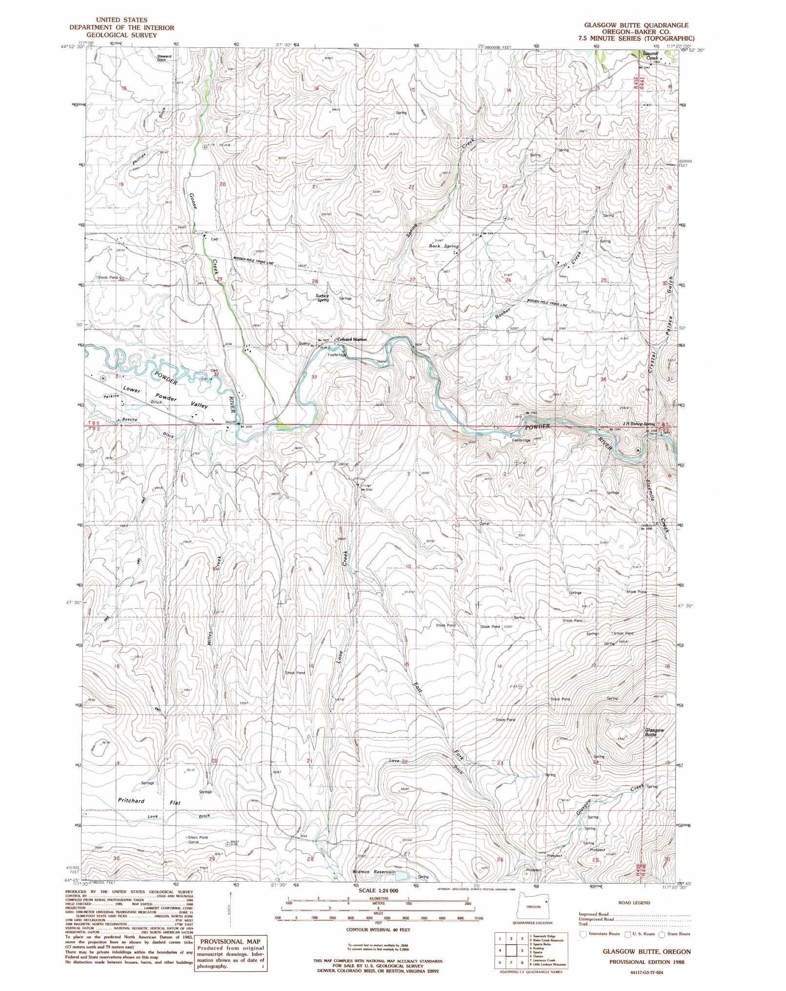
Glasgow Butte Topo Map Oregon
To zoom in, hover over the map of Glasgow Butte
USGS Topo Quad 44117g4 - 1:24,000 scale
| Topo Map Name: | Glasgow Butte |
| USGS Topo Quad ID: | 44117g4 |
| Print Size: | ca. 21 1/4" wide x 27" high |
| Southeast Coordinates: | 44.75° N latitude / 117.375° W longitude |
| Map Center Coordinates: | 44.8125° N latitude / 117.4375° W longitude |
| U.S. State: | OR |
| Filename: | o44117g4.jpg |
| Download Map JPG Image: | Glasgow Butte topo map 1:24,000 scale |
| Map Type: | Topographic |
| Topo Series: | 7.5´ |
| Map Scale: | 1:24,000 |
| Source of Map Images: | United States Geological Survey (USGS) |
| Alternate Map Versions: |
Glasgow Butte OR 1988, updated 1988 Download PDF Buy paper map Glasgow Butte OR 2011 Download PDF Buy paper map Glasgow Butte OR 2014 Download PDF Buy paper map |
| FStopo: | US Forest Service topo Glasgow Butte is available: Download FStopo PDF Download FStopo TIF |
1:24,000 Topo Quads surrounding Glasgow Butte
Medical Springs |
Flagstaff Butte |
Bennet Peak |
Krag Peak |
Cornucopia |
Keating Nw |
Sawtooth Ridge |
Balm Creek Reservoir |
Sparta Butte |
Jimtown |
Virtue Flat |
Keating |
Glasgow Butte |
Sparta |
Richland |
Encina |
Oxman |
Lawrence Creek |
Little Lookout Mountain |
Daly Creek |
French Gulch |
Lost Basin |
Durkee |
Big Lookout Mountain |
Connor Creek |
> Back to 44117e1 at 1:100,000 scale
> Back to 44116a1 at 1:250,000 scale
> Back to U.S. Topo Maps home
Glasgow Butte topo map: Gazetteer
Glasgow Butte: Canals
Steward Ditch elevation 947m 3106′Glasgow Butte: Dams
Saw Mill Gulch Dam elevation 1200m 3937′Widman Dam elevation 1206m 3956′
Glasgow Butte: Flats
Pritchard Flat elevation 1054m 3458′Glasgow Butte: Post Offices
Range Post Office (historical) elevation 1050m 3444′Glasgow Butte: Reservoirs
Bacher Creek Reservoir elevation 889m 2916′Grover Reservoir elevation 1200m 3937′
Widman Reservoir elevation 1206m 3956′
Glasgow Butte: Springs
Bacher Spring elevation 856m 2808′J N Bishop Spring elevation 804m 2637′
Magpie Spring elevation 1091m 3579′
Rock Spring elevation 946m 3103′
Surface Spring elevation 852m 2795′
Glasgow Butte: Streams
Bacher Creek elevation 802m 2631′East Fork Love Creek elevation 884m 2900′
Fivemile Creek elevation 774m 2539′
Glascow Creek elevation 1221m 4005′
Goose Creek elevation 802m 2631′
Love Creek elevation 792m 2598′
Miller Creek elevation 812m 2664′
Spring Creek elevation 798m 2618′
Glasgow Butte: Summits
Glasgow Butte elevation 1495m 4904′Glasgow Butte: Valleys
Corral Gulch elevation 772m 2532′Crenshaw Gulch elevation 777m 2549′
Crystal Palace Gulch elevation 786m 2578′
Glasgow Butte digital topo map on disk
Buy this Glasgow Butte topo map showing relief, roads, GPS coordinates and other geographical features, as a high-resolution digital map file on DVD: