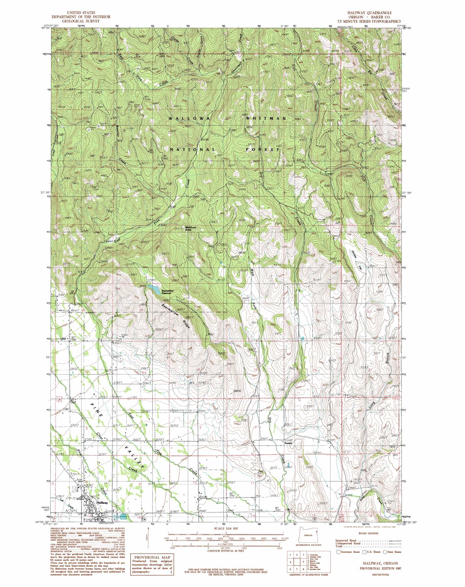
Halfway Topo Map Oregon
To zoom in, hover over the map of Halfway
USGS Topo Quad 44117h1 - 1:24,000 scale
| Topo Map Name: | Halfway |
| USGS Topo Quad ID: | 44117h1 |
| Print Size: | ca. 21 1/4" wide x 27" high |
| Southeast Coordinates: | 44.875° N latitude / 117° W longitude |
| Map Center Coordinates: | 44.9375° N latitude / 117.0625° W longitude |
| U.S. State: | OR |
| Filename: | o44117h1.jpg |
| Download Map JPG Image: | Halfway topo map 1:24,000 scale |
| Map Type: | Topographic |
| Topo Series: | 7.5´ |
| Map Scale: | 1:24,000 |
| Source of Map Images: | United States Geological Survey (USGS) |
| Alternate Map Versions: |
Halfway OR 1987, updated 1987 Download PDF Buy paper map Halfway OR 2011 Download PDF Buy paper map Halfway OR 2014 Download PDF Buy paper map |
| FStopo: | US Forest Service topo Halfway is available: Download FStopo PDF Download FStopo TIF |
1:24,000 Topo Quads surrounding Halfway
Eagle Cap |
Aneroid Mountain |
Lick Creek |
Gumboot Butte |
Puderbaugh Ridge |
Krag Peak |
Cornucopia |
Deadman Point |
Duck Creek |
Homestead |
Sparta Butte |
Jimtown |
Halfway |
Mclain Gulch |
Oxbow |
Sparta |
Richland |
Posy Valley |
Brownlee Dam |
Cuddy Mountain |
Little Lookout Mountain |
Daly Creek |
Sturgill Creek |
Neil Gulch |
Advent Gulch |
> Back to 44117e1 at 1:100,000 scale
> Back to 44116a1 at 1:250,000 scale
> Back to U.S. Topo Maps home
Halfway topo map: Gazetteer
Halfway: Dams
R K Moseley Dam elevation 1160m 3805′Halfway: Flats
Hooker Flat elevation 772m 2532′Halfway: Parks
Heritage Square elevation 806m 2644′Halfway: Populated Places
Halfway elevation 814m 2670′Sunset elevation 776m 2545′
Halfway: Post Offices
Halfway Post Office elevation 814m 2670′Sunset Post Office (historical) elevation 776m 2545′
Halfway: Reservoirs
Bearwallow Reservoir elevation 1140m 3740′Halfway: Ridges
Bearwallow Ridge elevation 1210m 3969′Halfway: Streams
Beecher Creek elevation 993m 3257′Clarks Creek elevation 1209m 3966′
Long Branch elevation 732m 2401′
Okanogan Creek elevation 1189m 3900′
Trinity Creek elevation 1235m 4051′
West Fork Dry Creek elevation 780m 2559′
Halfway: Summits
Mehlhorn Butte elevation 1146m 3759′Halfway: Valleys
Bearwallow Gulch elevation 868m 2847′Halfway digital topo map on disk
Buy this Halfway topo map showing relief, roads, GPS coordinates and other geographical features, as a high-resolution digital map file on DVD: