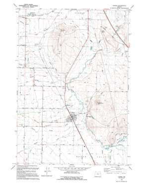
Haines Topo Map Oregon
To zoom in, hover over the map of Haines
USGS Topo Quad 44117h8 - 1:24,000 scale
| Topo Map Name: | Haines |
| USGS Topo Quad ID: | 44117h8 |
| Print Size: | ca. 21 1/4" wide x 27" high |
| Southeast Coordinates: | 44.875° N latitude / 117.875° W longitude |
| Map Center Coordinates: | 44.9375° N latitude / 117.9375° W longitude |
| U.S. State: | OR |
| Filename: | o44117h8.jpg |
| Download Map JPG Image: | Haines topo map 1:24,000 scale |
| Map Type: | Topographic |
| Topo Series: | 7.5´ |
| Map Scale: | 1:24,000 |
| Source of Map Images: | United States Geological Survey (USGS) |
| Alternate Map Versions: |
Haines OR 1967, updated 1971 Download PDF Buy paper map Haines OR 1994, updated 1994 Download PDF Buy paper map Haines OR 2011 Download PDF Buy paper map Haines OR 2014 Download PDF Buy paper map |
| FStopo: | US Forest Service topo Haines is available: Download FStopo PDF Download FStopo TIF |
1:24,000 Topo Quads surrounding Haines
> Back to 44117e1 at 1:100,000 scale
> Back to 44116a1 at 1:250,000 scale
> Back to U.S. Topo Maps home
Haines topo map: Gazetteer
Haines: Airports
Jensens Strip elevation 1025m 3362′Haines: Canals
Ellis Ditch elevation 1034m 3392′Jacobsen Ditch elevation 996m 3267′
Kelsey Wilson Ditch elevation 1031m 3382′
Moore Pratt Ditch elevation 1013m 3323′
Smith McPhee Ditch elevation 1015m 3330′
Travillion-Koester ditch elevation 992m 3254′
Haines: Dams
Pollman Dam elevation 1017m 3336′Haines: Lakes
Haines Pond Number One elevation 1016m 3333′Maxwell Pond elevation 1028m 3372′
North Powder Pond Number Two elevation 1028m 3372′
Haines: Populated Places
Haines elevation 1016m 3333′Hutchinson elevation 1031m 3382′
Haines: Post Offices
Haines Post Office elevation 1016m 3333′Hutchinson Post Office (historical) elevation 1031m 3382′
Haines: Ranges
Coyote Hills elevation 1119m 3671′Haines: Reservoirs
Inman Reservoir elevation 1003m 3290′Toney Reservoir elevation 1013m 3323′
Haines: Springs
Radium Hot Springs elevation 1010m 3313′Haines: Streams
Baldock Slough elevation 1014m 3326′Big Muddy Creek elevation 1008m 3307′
Christensen Slough elevation 1017m 3336′
Favorite Slough elevation 1013m 3323′
Fish Creek elevation 1010m 3313′
Hunt Creek elevation 1040m 3412′
Hutchinson Slough elevation 1034m 3392′
Little Muddy Creek elevation 1010m 3313′
Mid Slough elevation 1014m 3326′
Mink Creek elevation 1014m 3326′
Old Settlers Slough elevation 1013m 3323′
Rock Creek elevation 1010m 3313′
Salmon Creek elevation 1013m 3323′
Sand Creek elevation 1010m 3313′
Willow Creek elevation 1012m 3320′
Haines: Summits
Coyote Point elevation 1176m 3858′Hutchinson Hill elevation 1149m 3769′
Haines digital topo map on disk
Buy this Haines topo map showing relief, roads, GPS coordinates and other geographical features, as a high-resolution digital map file on DVD:


