Magpie Table Topo Map Oregon
To zoom in, hover over the map of Magpie Table
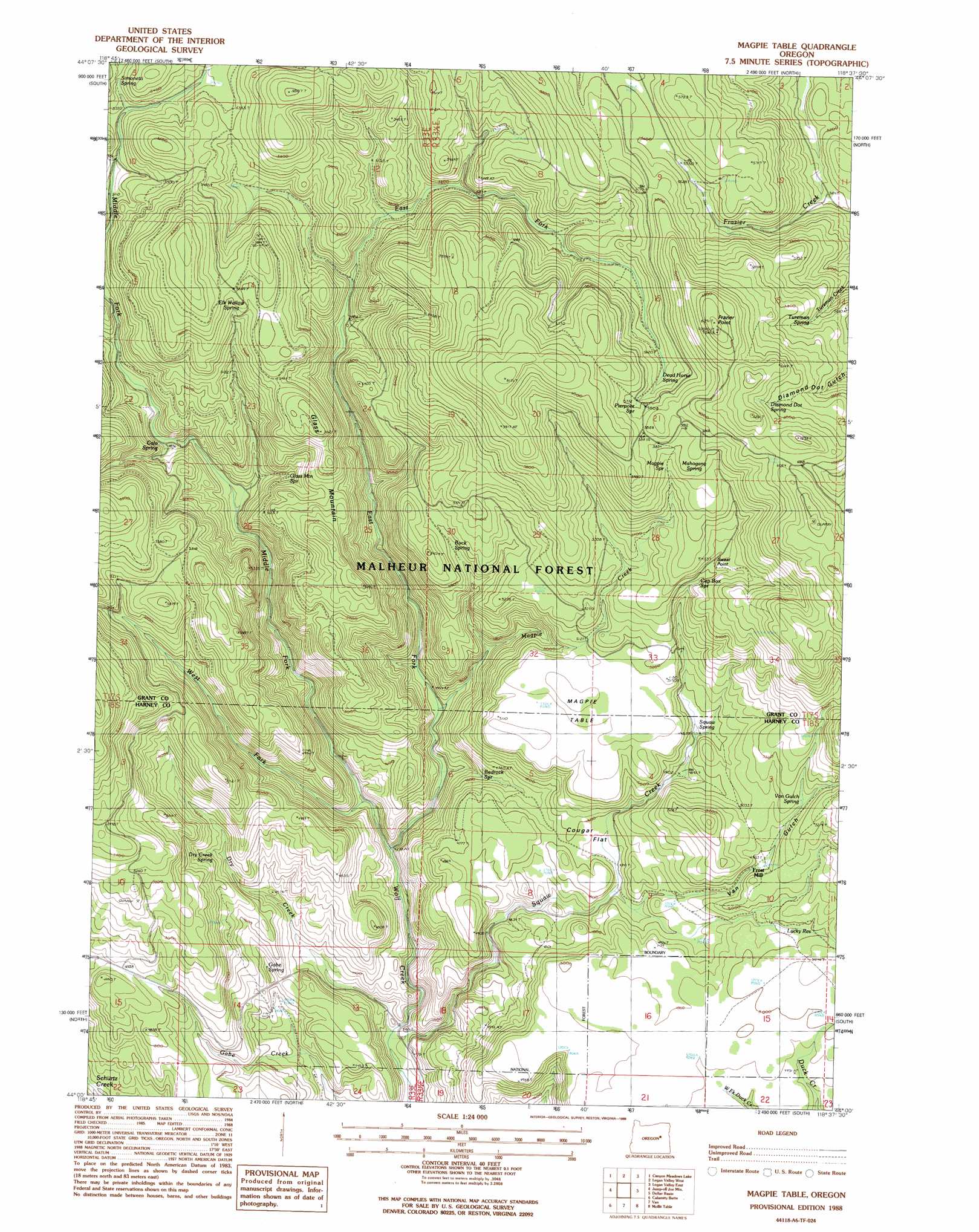
USGS Topo Quad 44118a6 - 1:24,000 scale
| Topo Map Name: | Magpie Table |
| USGS Topo Quad ID: | 44118a6 |
| Print Size: | ca. 21 1/4" wide x 27" high |
| Southeast Coordinates: | 44° N latitude / 118.625° W longitude |
| Map Center Coordinates: | 44.0625° N latitude / 118.6875° W longitude |
| U.S. State: | OR |
| Filename: | o44118a6.jpg |
| Download Map JPG Image: | Magpie Table topo map 1:24,000 scale |
| Map Type: | Topographic |
| Topo Series: | 7.5´ |
| Map Scale: | 1:24,000 |
| Source of Map Images: | United States Geological Survey (USGS) |
| Alternate Map Versions: |
Magpie Table OR 1988, updated 1988 Download PDF Buy paper map Magpie Table OR 1996, updated 1998 Download PDF Buy paper map Magpie Table OR 2011 Download PDF Buy paper map Magpie Table OR 2014 Download PDF Buy paper map |
| FStopo: | US Forest Service topo Magpie Table is available: Download FStopo PDF Download FStopo TIF |
1:24,000 Topo Quads surrounding Magpie Table
Canyon Mountain |
Pine Creek Mountain |
Strawberry Mountain |
Roberts Creek |
Little Baldy Mountain |
Seneca |
Big Canyon |
Logan Valley West |
Logan Valley East |
Crane Prairie |
Silvies |
Jumpoff Joe Mountain |
Magpie Table |
Dollar Basin |
Knox Mountain |
Trout Creek |
Calamity Butte |
Van |
Moffit Table |
Otis Mountain |
Devine Ridge North |
Telephone Butte |
Craft Point |
House Butte |
Drewsey |
> Back to 44118a1 at 1:100,000 scale
> Back to 44118a1 at 1:250,000 scale
> Back to U.S. Topo Maps home
Magpie Table topo map: Gazetteer
Magpie Table: Flats
Cougar Flat elevation 1452m 4763′Magpie Table: Populated Places
Frost Mill elevation 1523m 4996′Magpie Table: Reservoirs
Lucky Reservoir elevation 1515m 4970′Magpie Table: Springs
Bedrock Spring elevation 1402m 4599′Buck Spring elevation 1582m 5190′
Calo Spring elevation 1475m 4839′
Cap Box Spring elevation 1644m 5393′
Dead Horse Spring elevation 1732m 5682′
Diamond Dot Spring elevation 1806m 5925′
Dry Creek Spring elevation 1455m 4773′
Elk Wallow Spring elevation 1690m 5544′
Frazier Spring elevation 1568m 5144′
Gabe Spring elevation 1344m 4409′
Glass Mountain Spring elevation 1524m 5000′
Loperfido Spring elevation 1591m 5219′
Magpie Spring elevation 1751m 5744′
Mahogany Spring elevation 1760m 5774′
McMullen Spring elevation 1665m 5462′
Pierpont Spring elevation 1796m 5892′
Simonetti Spring elevation 1637m 5370′
Squaw Spring elevation 1514m 4967′
Tureman Spring elevation 1691m 5547′
Van Gulch Spring elevation 1556m 5104′
Magpie Table: Streams
Dry Creek elevation 1267m 4156′East Fork Wolf Creek elevation 1300m 4265′
Magpie Creek elevation 1336m 4383′
Middle Fork Wolf Creek elevation 1300m 4265′
Squaw Creek elevation 1260m 4133′
West Fork Wolf Creek elevation 1323m 4340′
Magpie Table: Summits
Frazier Point elevation 1916m 6286′Glass Mountain elevation 1707m 5600′
Magpie Table elevation 1565m 5134′
Sweat Point elevation 1673m 5488′
Magpie Table: Valleys
Van Gulch elevation 1434m 4704′Magpie Table digital topo map on disk
Buy this Magpie Table topo map showing relief, roads, GPS coordinates and other geographical features, as a high-resolution digital map file on DVD: