Little Baldy Mountain Topo Map Oregon
To zoom in, hover over the map of Little Baldy Mountain
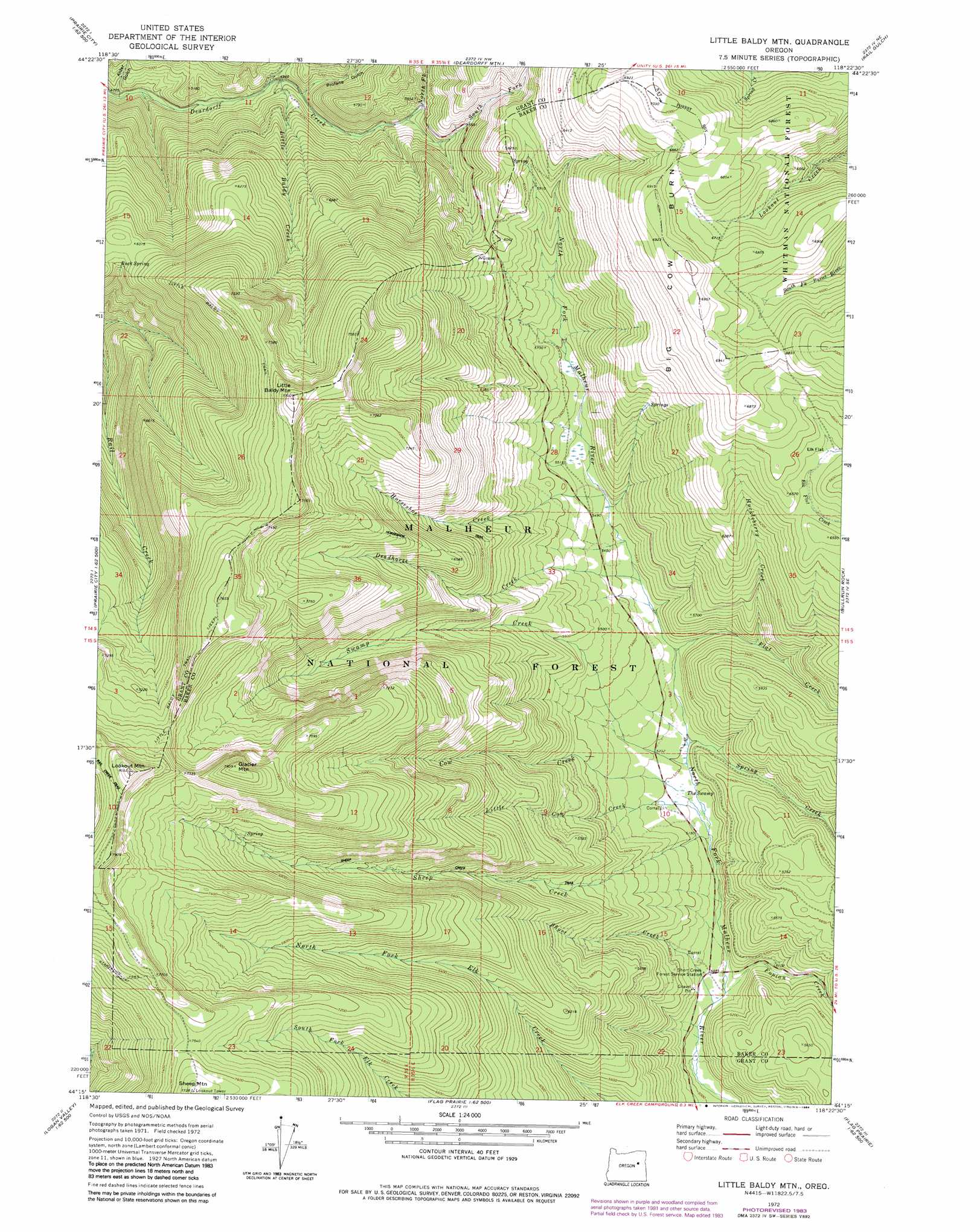
USGS Topo Quad 44118c4 - 1:24,000 scale
| Topo Map Name: | Little Baldy Mountain |
| USGS Topo Quad ID: | 44118c4 |
| Print Size: | ca. 21 1/4" wide x 27" high |
| Southeast Coordinates: | 44.25° N latitude / 118.375° W longitude |
| Map Center Coordinates: | 44.3125° N latitude / 118.4375° W longitude |
| U.S. State: | OR |
| Filename: | o44118c4.jpg |
| Download Map JPG Image: | Little Baldy Mountain topo map 1:24,000 scale |
| Map Type: | Topographic |
| Topo Series: | 7.5´ |
| Map Scale: | 1:24,000 |
| Source of Map Images: | United States Geological Survey (USGS) |
| Alternate Map Versions: |
Little Baldy Mnt. OR 1972, updated 1976 Download PDF Buy paper map Little Baldy Mtn. OR 1972, updated 1984 Download PDF Buy paper map Little Baldy Mountain OR 1998, updated 2000 Download PDF Buy paper map Little Baldy Mountain OR 2011 Download PDF Buy paper map Little Baldy Mountain OR 2014 Download PDF Buy paper map |
| FStopo: | US Forest Service topo Little Baldy Mountain is available: Download FStopo PDF Download FStopo TIF |
1:24,000 Topo Quads surrounding Little Baldy Mountain
Dixie Meadows |
Bates |
Austin |
Pogue Point |
Unity Reservoir |
Prairie City |
Isham Creek |
Deardorff Mountain |
Rail Gulch |
Unity |
Strawberry Mountain |
Roberts Creek |
Little Baldy Mountain |
Bullrun Rock |
Rastus Mountain |
Logan Valley West |
Logan Valley East |
Crane Prairie |
Flag Prairie |
Clevenger Butte |
Magpie Table |
Dollar Basin |
Knox Mountain |
Buck Trough Spring |
Castle Rock |
> Back to 44118a1 at 1:100,000 scale
> Back to 44118a1 at 1:250,000 scale
> Back to U.S. Topo Maps home
Little Baldy Mountain topo map: Gazetteer
Little Baldy Mountain: Areas
Big Cow Burn elevation 2044m 6706′Little Baldy Mountain: Flats
Elk Flat elevation 1985m 6512′Little Baldy Mountain: Springs
Buck Spring elevation 1881m 6171′Little Baldy Mountain: Streams
Cow Creek elevation 1562m 5124′Deadhorse Creek elevation 1630m 5347′
Flat Creek elevation 1610m 5282′
Fopian Creek elevation 1531m 5022′
Horseshoe Creek elevation 1657m 5436′
Huckleberry Creek elevation 1662m 5452′
Little Baldy Creek elevation 1512m 4960′
Little Cow Creek elevation 1569m 5147′
North Fork Deardorff Creek elevation 1594m 5229′
Sheep Creek elevation 1557m 5108′
Short Creek elevation 1527m 5009′
South Fork Deardorff Creek elevation 1625m 5331′
Spring Creek elevation 1585m 5200′
Swamp Creek elevation 1580m 5183′
Little Baldy Mountain: Summits
Glacier Mountain elevation 2406m 7893′Little Baldy Mountain elevation 2344m 7690′
Lookout Mountain elevation 2444m 8018′
Sheep Mountain elevation 2357m 7732′
Little Baldy Mountain: Swamps
The Swamp elevation 1578m 5177′Little Baldy Mountain: Trails
Little Baldy Trail (historical) elevation 2246m 7368′Starvation Trail elevation 2315m 7595′
Sunshine Flat Trail elevation 2373m 7785′
Little Baldy Mountain: Valleys
Alder Gulch elevation 1427m 4681′Escondia Gulch elevation 1507m 4944′
Profane Gulch elevation 1527m 5009′
Little Baldy Mountain digital topo map on disk
Buy this Little Baldy Mountain topo map showing relief, roads, GPS coordinates and other geographical features, as a high-resolution digital map file on DVD: