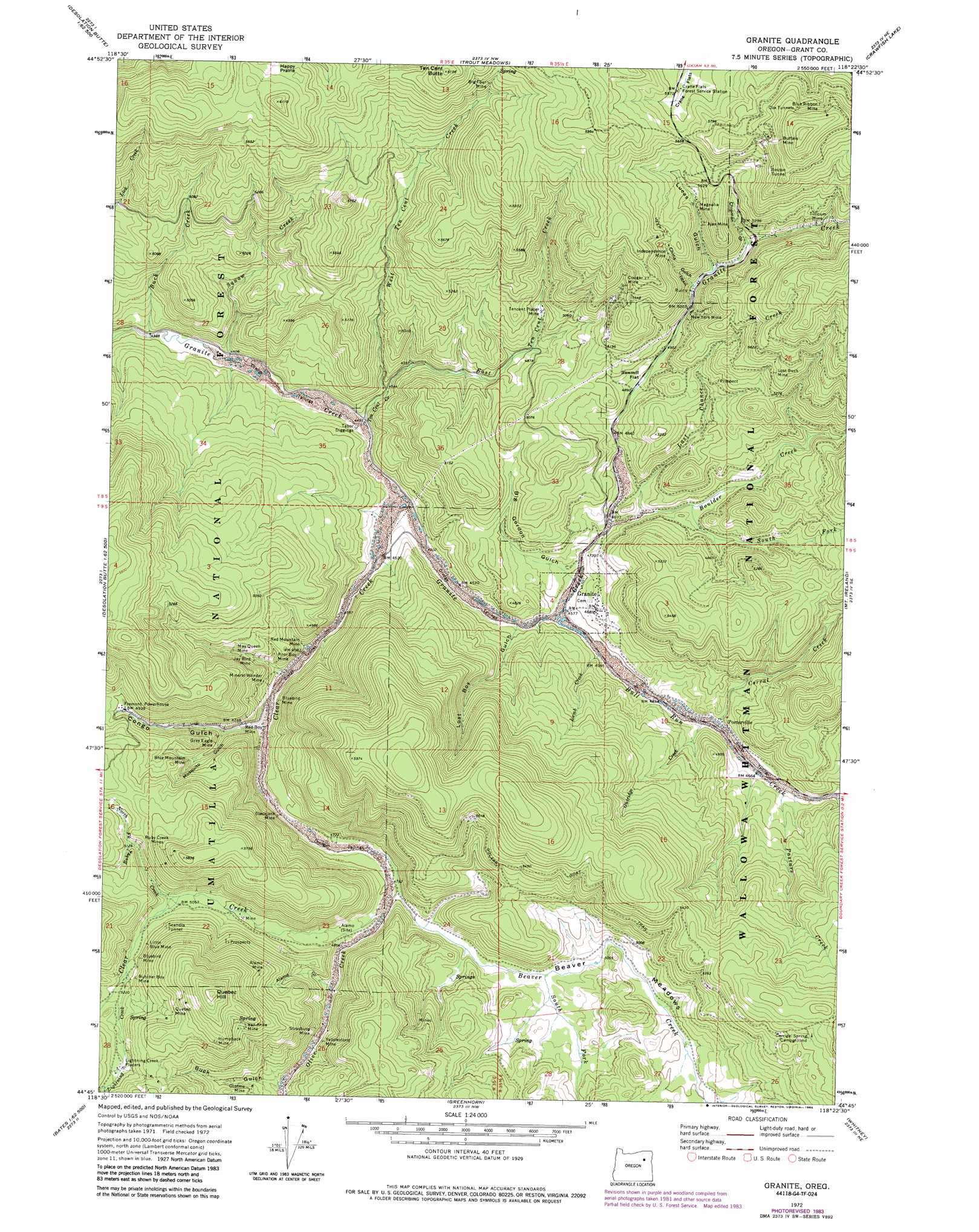
Granite Topo Map Oregon
To zoom in, hover over the map of Granite
USGS Topo Quad 44118g4 - 1:24,000 scale
| Topo Map Name: | Granite |
| USGS Topo Quad ID: | 44118g4 |
| Print Size: | ca. 21 1/4" wide x 27" high |
| Southeast Coordinates: | 44.75° N latitude / 118.375° W longitude |
| Map Center Coordinates: | 44.8125° N latitude / 118.4375° W longitude |
| U.S. State: | OR |
| Filename: | o44118g4.jpg |
| Download Map JPG Image: | Granite topo map 1:24,000 scale |
| Map Type: | Topographic |
| Topo Series: | 7.5´ |
| Map Scale: | 1:24,000 |
| Source of Map Images: | United States Geological Survey (USGS) |
| Alternate Map Versions: |
Granite OR 1972, updated 1976 Download PDF Buy paper map Granite OR 1972, updated 1985 Download PDF Buy paper map Granite OR 1995, updated 1998 Download PDF Buy paper map Granite OR 2011 Download PDF Buy paper map Granite OR 2014 Download PDF Buy paper map |
| FStopo: | US Forest Service topo Granite is available: Download FStopo PDF Download FStopo TIF |
1:24,000 Topo Quads surrounding Granite
Pearson Ridge |
Tower Mountain |
Fly Valley |
Limber Jim Creek |
Anthony Butte |
Kelsay Butte |
Silver Butte |
Trout Meadows |
Crawfish Lake |
Anthony Lakes |
Desolation Butte |
Olive Lake |
Granite |
Mount Ireland |
Bourne |
Boulder Butte |
Vinegar Hill |
Greenhorn |
Whitney |
Sumpter |
Dixie Meadows |
Bates |
Austin |
Pogue Point |
Unity Reservoir |
> Back to 44118e1 at 1:100,000 scale
> Back to 44118a1 at 1:250,000 scale
> Back to U.S. Topo Maps home
Granite topo map: Gazetteer
Granite: Flats
Beaver Meadows elevation 1488m 4881′Happy Prairie elevation 1786m 5859′
Sawmill Flat elevation 1505m 4937′
Granite: Mines
Ajax Mine elevation 1621m 5318′Alamo Mine elevation 1706m 5597′
Big Four Mine elevation 1722m 5649′
Blackjack Mine elevation 1453m 4767′
Blue Mountain Mine elevation 1488m 4881′
Blue Ribbon Mine elevation 1843m 6046′
Bluebird Mine elevation 1439m 4721′
Bluebird Mine elevation 1594m 5229′
Boston Tunnel elevation 1776m 5826′
Buffalo Mine elevation 1864m 6115′
Butcher Boy Mine elevation 1617m 5305′
Cougar Mine elevation 1643m 5390′
Cox Tunnels elevation 1882m 6174′
Gray Eagle Mine elevation 1469m 4819′
Humpback Mine elevation 1768m 5800′
Independence Mine elevation 1649m 5410′
Jay Bird Mine elevation 1451m 4760′
Lightning Creek Placers elevation 1622m 5321′
Little Blue Mine elevation 1586m 5203′
Lost Buck Mine elevation 1661m 5449′
Magnolia Mine elevation 1620m 5314′
May Queen Mine elevation 1482m 4862′
Mineral Wonder Mine elevation 1437m 4714′
New York Mine elevation 1533m 5029′
Poor Boy Mine elevation 1434m 4704′
Quebec Mine elevation 1784m 5853′
Red Boy Mine elevation 1447m 4747′
Red Mountain Mine elevation 1431m 4694′
Ruby Creek Mines elevation 1706m 5597′
Scandia Tunnel elevation 1600m 5249′
Strasburg Mine elevation 1520m 4986′
Tabor Diggings elevation 1358m 4455′
Tencent Placer Mine elevation 1494m 4901′
Tillicum Mine elevation 1646m 5400′
Van Anda Mine elevation 1754m 5754′
Yellowstone Mine elevation 1533m 5029′
Granite: Populated Places
Granite elevation 1431m 4694′Porterville (historical) elevation 1425m 4675′
Granite: Post Offices
Alamo Post Office (historical) elevation 1486m 4875′Granite Post Office (historical) elevation 1431m 4694′
Lawton Post Office (historical) elevation 1385m 4543′
Redboy Post Office (historical) elevation 1478m 4849′
Granite: Springs
Corrigal Spring elevation 1721m 5646′Granite: Streams
Beaver Creek elevation 1461m 4793′Boulder Creek elevation 1422m 4665′
Buck Creek elevation 1331m 4366′
Bull Run Creek elevation 1395m 4576′
Clear Creek elevation 1366m 4481′
Corral Creek elevation 1415m 4642′
Dry Creek elevation 1642m 5387′
East Ten Cent Creek elevation 1380m 4527′
Gutridge Creek elevation 1412m 4632′
Lamb Creek elevation 1399m 4589′
Last Chance Creek elevation 1433m 4701′
Lightning Creek elevation 1578m 5177′
North Fork Ruby Creek elevation 1565m 5134′
Olive Creek elevation 1447m 4747′
Pasture Creek elevation 1424m 4671′
Ruby Creek elevation 1544m 5065′
South Fork Beaver Creek elevation 1481m 4858′
South Fork Boulder Creek elevation 1441m 4727′
South Fork Ruby Creek elevation 1565m 5134′
Squaw Creek elevation 1337m 4386′
Ten Cent Creek elevation 1354m 4442′
West Ten Cent Creek elevation 1380m 4527′
Granite: Summits
Alamo Hill elevation 1769m 5803′Quebec Hill elevation 1906m 6253′
Ten Cent Butte elevation 1868m 6128′
Granite: Trails
Golars Goat Trail elevation 1672m 5485′Granite: Valleys
Alamo Gulch elevation 1493m 4898′Big Gordon Gulch elevation 1401m 4596′
Buck Gulch elevation 1533m 5029′
China Gulch elevation 1531m 5022′
Chipman Gulch elevation 1567m 5141′
Congo Gulch elevation 1410m 4625′
Lost Boy Gulch elevation 1386m 4547′
Lucas Gulch elevation 1541m 5055′
Mosquito Gulch elevation 1439m 4721′
Granite digital topo map on disk
Buy this Granite topo map showing relief, roads, GPS coordinates and other geographical features, as a high-resolution digital map file on DVD: