Olive Lake Topo Map Oregon
To zoom in, hover over the map of Olive Lake
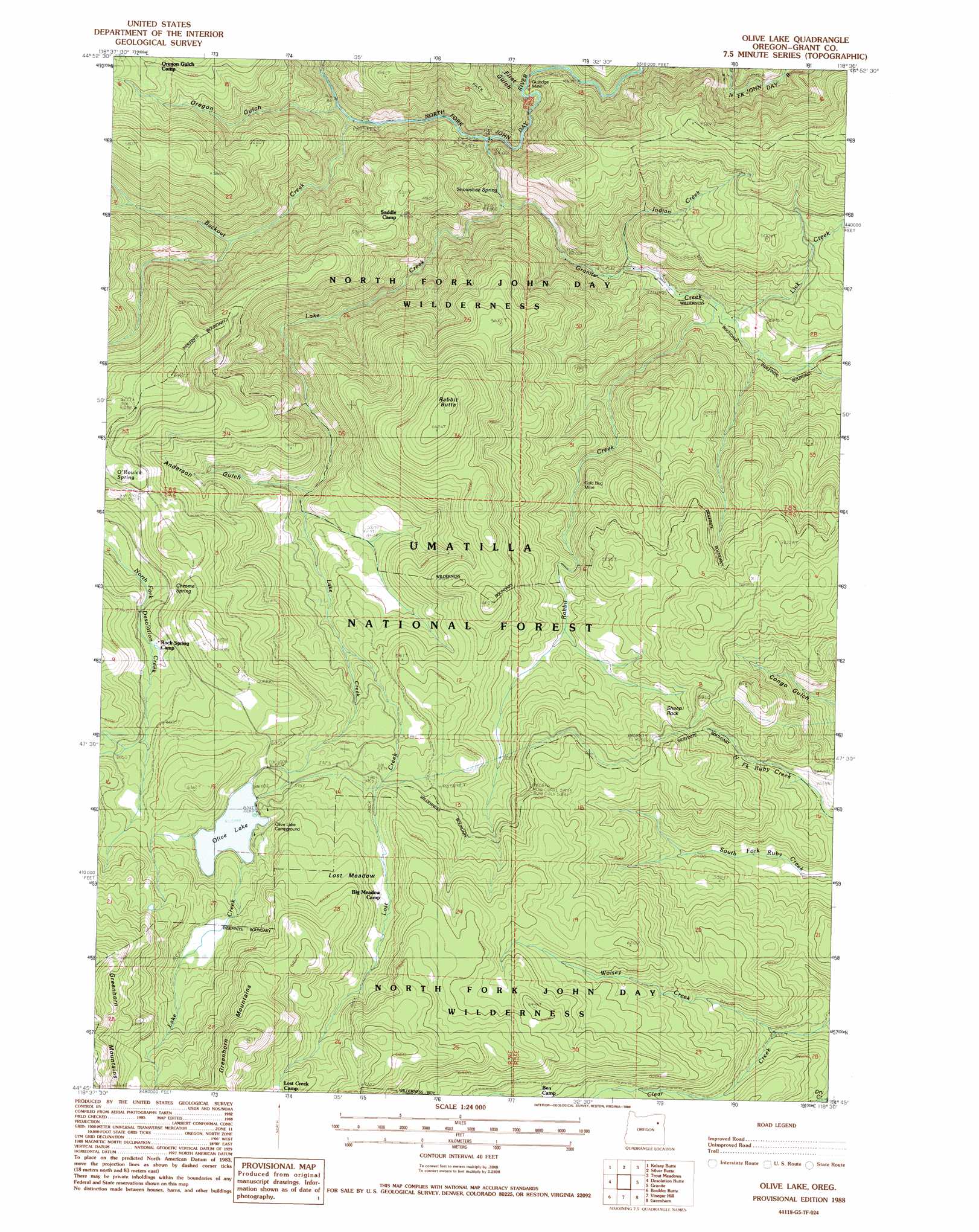
USGS Topo Quad 44118g5 - 1:24,000 scale
| Topo Map Name: | Olive Lake |
| USGS Topo Quad ID: | 44118g5 |
| Print Size: | ca. 21 1/4" wide x 27" high |
| Southeast Coordinates: | 44.75° N latitude / 118.5° W longitude |
| Map Center Coordinates: | 44.8125° N latitude / 118.5625° W longitude |
| U.S. State: | OR |
| Filename: | o44118g5.jpg |
| Download Map JPG Image: | Olive Lake topo map 1:24,000 scale |
| Map Type: | Topographic |
| Topo Series: | 7.5´ |
| Map Scale: | 1:24,000 |
| Source of Map Images: | United States Geological Survey (USGS) |
| Alternate Map Versions: |
Olive Lake OR 1988, updated 1988 Download PDF Buy paper map Olive Lake OR 2011 Download PDF Buy paper map Olive Lake OR 2014 Download PDF Buy paper map |
| FStopo: | US Forest Service topo Olive Lake is available: Download FStopo PDF Download FStopo TIF |
1:24,000 Topo Quads surrounding Olive Lake
Ukiah Se |
Pearson Ridge |
Tower Mountain |
Fly Valley |
Limber Jim Creek |
The Cockscomb |
Kelsay Butte |
Silver Butte |
Trout Meadows |
Crawfish Lake |
Sharp Ridge |
Desolation Butte |
Olive Lake |
Granite |
Mount Ireland |
Susanville |
Boulder Butte |
Vinegar Hill |
Greenhorn |
Whitney |
Cougar Rock |
Dixie Meadows |
Bates |
Austin |
Pogue Point |
> Back to 44118e1 at 1:100,000 scale
> Back to 44118a1 at 1:250,000 scale
> Back to U.S. Topo Maps home
Olive Lake topo map: Gazetteer
Olive Lake: Dams
Olive Lake Dam elevation 1833m 6013′Olive Lake: Flats
Lost Meadow elevation 1853m 6079′Olive Lake: Lakes
Olive Lake elevation 1833m 6013′Olive Lake: Mines
Gold Bug Mine elevation 1616m 5301′Gutridge Mine elevation 1244m 4081′
Olive Lake: Reservoirs
Upper Reservoir elevation 1894m 6213′Olive Lake: Springs
Chrome Spring elevation 1845m 6053′O'Rouick Spring elevation 1810m 5938′
Snowshoe Spring elevation 1232m 4041′
Olive Lake: Streams
Backout Creek elevation 1199m 3933′East Fork of North Fork Desolation Creek elevation 1829m 6000′
Granite Creek elevation 1234m 4048′
Indian Creek elevation 1274m 4179′
Lake Creek elevation 1209m 3966′
Lick Creek elevation 1304m 4278′
Lost Creek elevation 1670m 5479′
Rabbit Creek elevation 1296m 4251′
West Fork of North Fork Desolation Creek elevation 1825m 5987′
Wolsey Creek elevation 1639m 5377′
Olive Lake: Summits
Rabbit Butte elevation 1960m 6430′Sheep Rock elevation 1752m 5748′
Olive Lake: Trails
Chinaman Trail elevation 1753m 5751′Lake Creek Trail elevation 1849m 6066′
Silver Hill Trail elevation 1503m 4931′
Spruce Log Trail elevation 1819m 5967′
Olive Lake: Valleys
Anderson Gulch elevation 1550m 5085′Dry Gulch elevation 1475m 4839′
First Gulch elevation 1225m 4019′
Oregon Gulch elevation 1191m 3907′
Olive Lake digital topo map on disk
Buy this Olive Lake topo map showing relief, roads, GPS coordinates and other geographical features, as a high-resolution digital map file on DVD: