Kelsay Butte Topo Map Oregon
To zoom in, hover over the map of Kelsay Butte
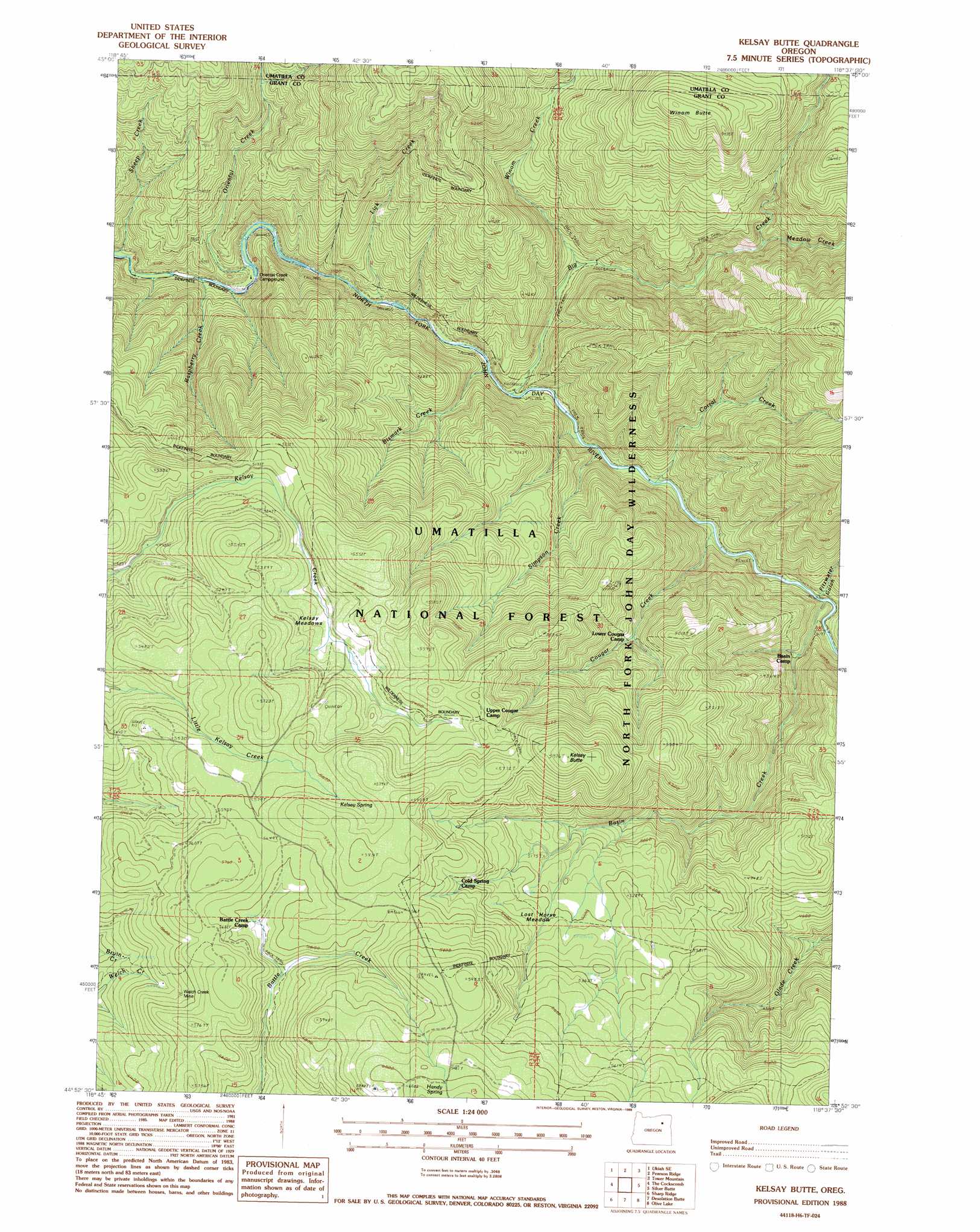
USGS Topo Quad 44118h6 - 1:24,000 scale
| Topo Map Name: | Kelsay Butte |
| USGS Topo Quad ID: | 44118h6 |
| Print Size: | ca. 21 1/4" wide x 27" high |
| Southeast Coordinates: | 44.875° N latitude / 118.625° W longitude |
| Map Center Coordinates: | 44.9375° N latitude / 118.6875° W longitude |
| U.S. State: | OR |
| Filename: | o44118h6.jpg |
| Download Map JPG Image: | Kelsay Butte topo map 1:24,000 scale |
| Map Type: | Topographic |
| Topo Series: | 7.5´ |
| Map Scale: | 1:24,000 |
| Source of Map Images: | United States Geological Survey (USGS) |
| Alternate Map Versions: |
Kelsay Butte OR 1988, updated 1988 Download PDF Buy paper map Kelsay Butte OR 1995, updated 1998 Download PDF Buy paper map Kelsay Butte OR 2011 Download PDF Buy paper map Kelsay Butte OR 2014 Download PDF Buy paper map |
| FStopo: | US Forest Service topo Kelsay Butte is available: Download FStopo PDF Download FStopo TIF |
1:24,000 Topo Quads surrounding Kelsay Butte
Ukiah |
Owens Butte |
Lehman Springs |
Sullivan Gulch |
Marley Creek |
Bridge Creek |
Ukiah Se |
Pearson Ridge |
Tower Mountain |
Fly Valley |
Dale |
The Cockscomb |
Kelsay Butte |
Silver Butte |
Trout Meadows |
Wildcat Point |
Sharp Ridge |
Desolation Butte |
Olive Lake |
Granite |
Keeney Point |
Susanville |
Boulder Butte |
Vinegar Hill |
Greenhorn |
> Back to 44118e1 at 1:100,000 scale
> Back to 44118a1 at 1:250,000 scale
> Back to U.S. Topo Maps home
Kelsay Butte topo map: Gazetteer
Kelsay Butte: Flats
Kelsay Meadows elevation 1590m 5216′Lost Horse Meadow elevation 1584m 5196′
Kelsay Butte: Mines
Welch Creek Mine elevation 1657m 5436′Kelsay Butte: Springs
Handy Spring elevation 1846m 6056′Kelsay Spring elevation 1706m 5597′
Kelsay Butte: Streams
Basin Creek elevation 1100m 3608′Big Creek elevation 1038m 3405′
Bismark Creek elevation 1025m 3362′
Corral Creek elevation 1058m 3471′
Cougar Creek elevation 1086m 3562′
Lick Creek elevation 1025m 3362′
Meadow Creek elevation 1311m 4301′
Oriental Creek elevation 980m 3215′
Raspberry Creek elevation 980m 3215′
Sheep Creek elevation 972m 3188′
Simpson Creek elevation 1047m 3435′
Winom Creek elevation 1101m 3612′
Kelsay Butte: Summits
Kelsay Butte elevation 1822m 5977′Winom Butte elevation 1816m 5958′
Kelsay Butte: Trails
Basin Creek Trail elevation 1587m 5206′Bull Prairie Trail elevation 1771m 5810′
Corral Creek Trail elevation 1540m 5052′
Cougar Creek Trail elevation 1483m 4865′
Glade Creek Trail elevation 1685m 5528′
Kelsay Butte Trail elevation 1720m 5643′
Old Desolation Driveway Trail elevation 1514m 4967′
Welch Creek Trail elevation 1717m 5633′
Kelsay Butte: Valleys
Fitzwater Gulch elevation 1096m 3595′Kelsay Butte digital topo map on disk
Buy this Kelsay Butte topo map showing relief, roads, GPS coordinates and other geographical features, as a high-resolution digital map file on DVD: