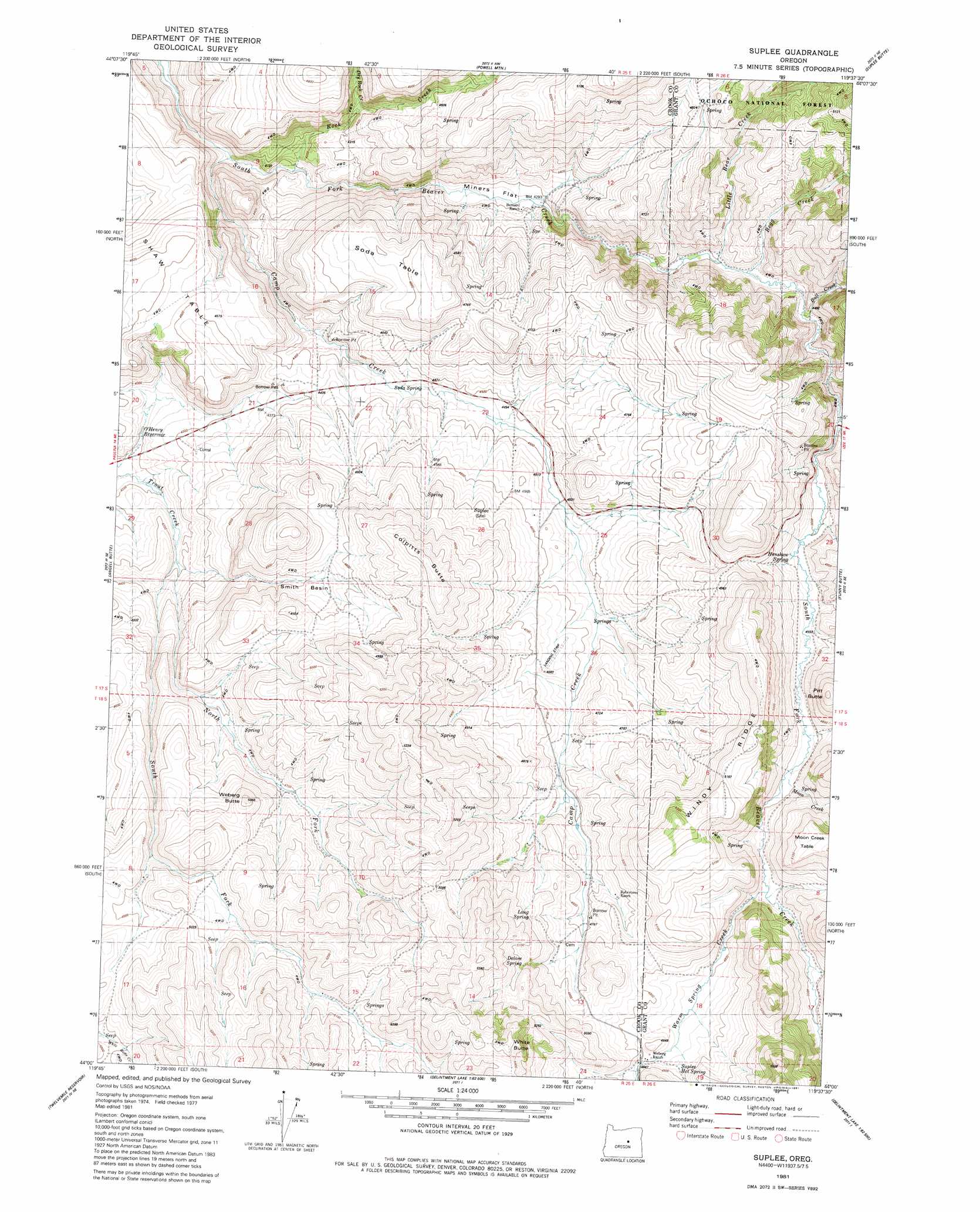
Suplee Topo Map Oregon
To zoom in, hover over the map of Suplee
USGS Topo Quad 44119a6 - 1:24,000 scale
| Topo Map Name: | Suplee |
| USGS Topo Quad ID: | 44119a6 |
| Print Size: | ca. 21 1/4" wide x 27" high |
| Southeast Coordinates: | 44° N latitude / 119.625° W longitude |
| Map Center Coordinates: | 44.0625° N latitude / 119.6875° W longitude |
| U.S. State: | OR |
| Filename: | o44119a6.jpg |
| Download Map JPG Image: | Suplee topo map 1:24,000 scale |
| Map Type: | Topographic |
| Topo Series: | 7.5´ |
| Map Scale: | 1:24,000 |
| Source of Map Images: | United States Geological Survey (USGS) |
| Alternate Map Versions: |
Suplee OR 1981, updated 1981 Download PDF Buy paper map Suplee OR 1992, updated 1997 Download PDF Buy paper map Suplee OR 2011 Download PDF Buy paper map Suplee OR 2014 Download PDF Buy paper map |
| FStopo: | US Forest Service topo Suplee is available: Download FStopo PDF Download FStopo TIF |
1:24,000 Topo Quads surrounding Suplee
Little Summit Prairie |
Six Corners |
Wolf Mountain |
Aldrich Gulch |
Aldrich Mountain South |
Paulina |
Mud Spring |
Powell Mountain |
Suplee Butte |
Graylock Butte |
Maupin Butte |
Angell Butte |
Suplee |
Funny Butte |
Izee |
Hardin Ranch |
Twelvemile Reservoir |
Delintment Lake |
Big Mowich Mountain |
Whiskey Mountain |
Ibex Butte |
Mackey Butte |
Buck Spring |
Donnelly Butte |
Bear Canyon Butte |
> Back to 44119a1 at 1:100,000 scale
> Back to 44118a1 at 1:250,000 scale
> Back to U.S. Topo Maps home
Suplee topo map: Gazetteer
Suplee: Basins
Smith Basin elevation 1437m 4714′Suplee: Flats
Miners Flat elevation 1301m 4268′Suplee: Populated Places
Suplee elevation 1390m 4560′Suplee: Post Offices
Stewart Post Office (historical) elevation 1359m 4458′Suplee Post Office (historical) elevation 1390m 4560′
Suplee: Reservoirs
O'Henry Reservoir elevation 1500m 4921′Suplee: Ridges
Windy Ridge elevation 1570m 5150′Suplee: Springs
Delore Spring elevation 1539m 5049′Henshaw Spring elevation 1415m 4642′
Long Spring elevation 1518m 4980′
Soda Spring elevation 1354m 4442′
Suplee Hot Spring elevation 1480m 4855′
Suplee: Streams
Camp Creek elevation 1223m 4012′Dry Rock Creek elevation 1311m 4301′
Little Bear Creek elevation 1342m 4402′
Negro Creek elevation 1382m 4534′
North Fork Trout Creek elevation 1304m 4278′
Pole Creek elevation 1382m 4534′
Rock Creek elevation 1248m 4094′
South Fork Trout Creek elevation 1304m 4278′
Warm Springs Creek elevation 1441m 4727′
Suplee: Summits
Colpitts Butte elevation 1581m 5187′Pitt Butte elevation 1596m 5236′
Soda Table elevation 1461m 4793′
Weberg Butte elevation 1525m 5003′
Suplee digital topo map on disk
Buy this Suplee topo map showing relief, roads, GPS coordinates and other geographical features, as a high-resolution digital map file on DVD: