Mcclellan Mountain Topo Map Oregon
To zoom in, hover over the map of Mcclellan Mountain
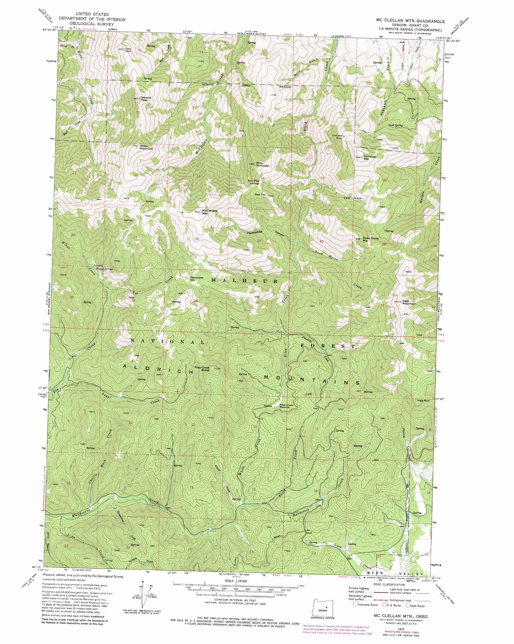
USGS Topo Quad 44119c2 - 1:24,000 scale
| Topo Map Name: | Mcclellan Mountain |
| USGS Topo Quad ID: | 44119c2 |
| Print Size: | ca. 21 1/4" wide x 27" high |
| Southeast Coordinates: | 44.25° N latitude / 119.125° W longitude |
| Map Center Coordinates: | 44.3125° N latitude / 119.1875° W longitude |
| U.S. State: | OR |
| Filename: | o44119c2.jpg |
| Download Map JPG Image: | Mcclellan Mountain topo map 1:24,000 scale |
| Map Type: | Topographic |
| Topo Series: | 7.5´ |
| Map Scale: | 1:24,000 |
| Source of Map Images: | United States Geological Survey (USGS) |
| Alternate Map Versions: |
Mc Clellan Mtn OR 1972, updated 1976 Download PDF Buy paper map Mc Clellan Mtn OR 1972, updated 1981 Download PDF Buy paper map Mc Clellan Mtn OR 1972, updated 1984 Download PDF Buy paper map Mc Clellan Mountain OR 1998, updated 2000 Download PDF Buy paper map McClellan Mountain OR 2011 Download PDF Buy paper map McClellan Mountain OR 2014 Download PDF Buy paper map |
| FStopo: | US Forest Service topo McClellan Mountain is available: Download FStopo PDF Download FStopo TIF |
1:24,000 Topo Quads surrounding Mcclellan Mountain
Sheep Ridge |
Donaldson Creek |
Belshaw Meadows |
Beech Creek Summit |
Magone Lake |
Aldrich Mountain North |
Shop Gulch |
Wolfinger Butte |
Mount Vernon |
John Day |
Aldrich Mountain South |
Big Weasel Sprs |
Mcclellan Mountain |
Fall Mountain |
Canyon Mountain |
Graylock Butte |
Flagtail Mountain |
Logdell |
Scotty Creek |
Seneca |
Izee |
Lewis Creek |
Five Hundred Flat |
Rail Creek Butte |
Silvies |
> Back to 44119a1 at 1:100,000 scale
> Back to 44118a1 at 1:250,000 scale
> Back to U.S. Topo Maps home
Mcclellan Mountain topo map: Gazetteer
Mcclellan Mountain: Basins
The Hole elevation 1492m 4895′Mcclellan Mountain: Flats
Bear Flat elevation 1734m 5688′Riley Creek Meadows elevation 1543m 5062′
Mcclellan Mountain: Gaps
Packsaddle Gap elevation 1747m 5731′Mcclellan Mountain: Mines
Cinnabar Mine elevation 1696m 5564′Mcclellan Mountain: Pillars
Ingle Rock elevation 1939m 6361′Mcclellan Mountain: Springs
Bear Flat Springs elevation 1693m 5554′Cold Spring elevation 1509m 4950′
Hoppy Spring elevation 1551m 5088′
Mcclellan Mountain: Streams
Alkali Creek elevation 1439m 4721′Basin Creek elevation 1445m 4740′
Charlie Mack Creek elevation 1369m 4491′
Dead Horse Creek elevation 1365m 4478′
Grapefruit Creek elevation 1380m 4527′
Lime Creek elevation 1362m 4468′
Miner Creek elevation 1509m 4950′
Rail Creek elevation 1300m 4265′
Sugar Creek elevation 1419m 4655′
Third Creek elevation 1115m 3658′
Umatilla Creek elevation 1441m 4727′
White Creek elevation 1434m 4704′
Mcclellan Mountain: Summits
Cinnabar Mountain elevation 1869m 6131′Dead Horse Mountain elevation 1838m 6030′
First Peak elevation 1788m 5866′
Ingle Mountain elevation 2063m 6768′
McClellan Mountain elevation 2126m 6975′
Moon Mountain elevation 2128m 6981′
Riley Creek Butte elevation 1854m 6082′
Riley Mountain elevation 1877m 6158′
Second Peak elevation 1989m 6525′
Mcclellan Mountain: Trails
High Trail elevation 1586m 5203′Mcclellan Mountain: Valleys
Buck Gulch elevation 984m 3228′Packsaddle Canyon elevation 1366m 4481′
Spring Gulch elevation 995m 3264′
Mcclellan Mountain digital topo map on disk
Buy this Mcclellan Mountain topo map showing relief, roads, GPS coordinates and other geographical features, as a high-resolution digital map file on DVD: