Picture Gorge West Topo Map Oregon
To zoom in, hover over the map of Picture Gorge West
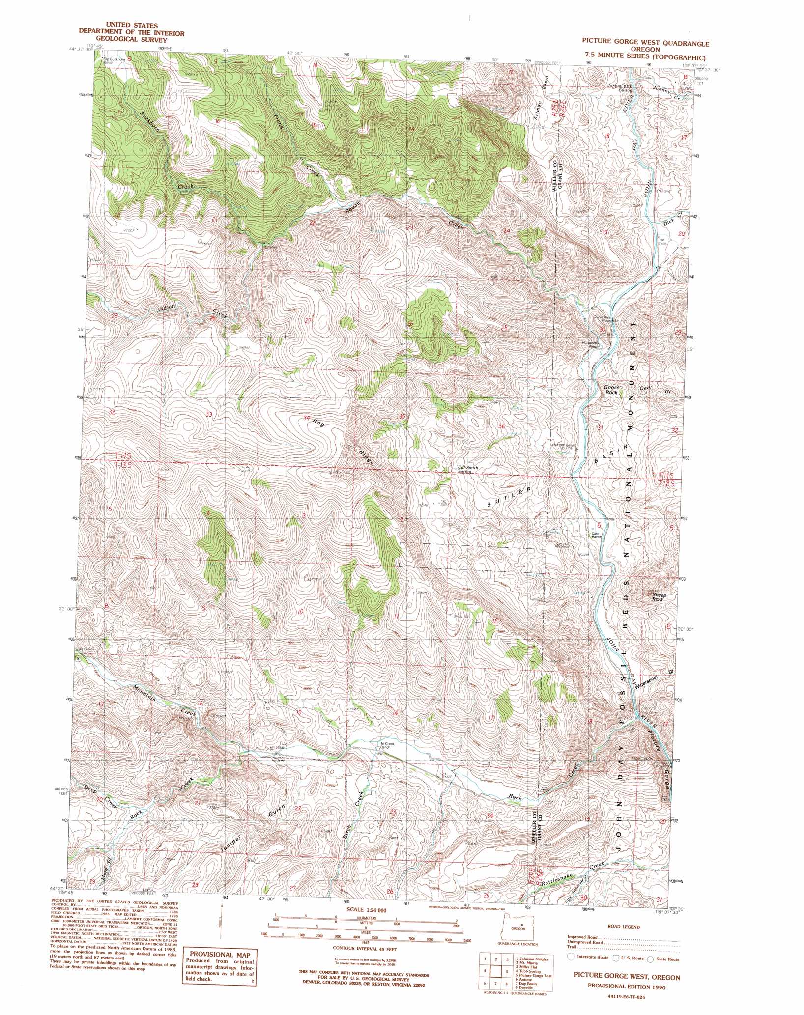
USGS Topo Quad 44119e6 - 1:24,000 scale
| Topo Map Name: | Picture Gorge West |
| USGS Topo Quad ID: | 44119e6 |
| Print Size: | ca. 21 1/4" wide x 27" high |
| Southeast Coordinates: | 44.5° N latitude / 119.625° W longitude |
| Map Center Coordinates: | 44.5625° N latitude / 119.6875° W longitude |
| U.S. State: | OR |
| Filename: | o44119e6.jpg |
| Download Map JPG Image: | Picture Gorge West topo map 1:24,000 scale |
| Map Type: | Topographic |
| Topo Series: | 7.5´ |
| Map Scale: | 1:24,000 |
| Source of Map Images: | United States Geological Survey (USGS) |
| Alternate Map Versions: |
Picture Gorge West OR 1990, updated 1990 Download PDF Buy paper map Picture Gorge West OR 2011 Download PDF Buy paper map Picture Gorge West OR 2014 Download PDF Buy paper map |
1:24,000 Topo Quads surrounding Picture Gorge West
Massacre Mountain |
Spray |
Kimberly |
Bologna Basin |
Monument |
Richmond |
Johnson Heights |
Mount Misery |
Miller Flat |
Courthouse Rock |
Frog Hollow |
Tubb Spring |
Picture Gorge West |
Picture Gorge East |
Sheep Ridge |
Derr Meadows |
Antone |
Day Basin |
Dayville |
Aldrich Mountain North |
Little Summit Prairie |
Six Corners |
Wolf Mountain |
Aldrich Gulch |
Aldrich Mountain South |
> Back to 44119e1 at 1:100,000 scale
> Back to 44118a1 at 1:250,000 scale
> Back to U.S. Topo Maps home
Picture Gorge West topo map: Gazetteer
Picture Gorge West: Basins
Butler Basin elevation 663m 2175′Picture Gorge West: Benches
Artman Basin elevation 800m 2624′Picture Gorge West: Bridges
Goose Rock Bridge elevation 651m 2135′Picture Gorge West: Cliffs
Goose Rock elevation 663m 2175′Picture Gorge West: Parks
John Day Fossil Beds National Monument elevation 766m 2513′Picture Gorge West: Pillars
Sheep Rock elevation 925m 3034′Picture Gorge West: Ridges
Hog Ridge elevation 1356m 4448′Jerrys Ridge elevation 1293m 4242′
Picture Gorge West: Springs
Cal Smith Spring elevation 939m 3080′Johnny Kirk Spring elevation 668m 2191′
Picture Gorge West: Streams
Birch Creek elevation 756m 2480′Buckhorn Creek elevation 1000m 3280′
Deep Creek elevation 862m 2828′
Dick Creek elevation 641m 2103′
Frank Creek elevation 956m 3136′
Indian Creek elevation 999m 3277′
Johnny Creek elevation 662m 2171′
Little Rattlesnake Creek elevation 736m 2414′
Mountain Creek elevation 788m 2585′
Rock Creek elevation 677m 2221′
Squaw Creek elevation 652m 2139′
Picture Gorge West: Trails
Lone Pine Trail elevation 1172m 3845′Picture Gorge West: Valleys
Deer Gulch elevation 691m 2267′Jerrys Draw elevation 768m 2519′
Juniper Gulch elevation 793m 2601′
Mule Gulch elevation 874m 2867′
Picture Gorge elevation 674m 2211′
Waterspout Gulch elevation 710m 2329′
Picture Gorge West digital topo map on disk
Buy this Picture Gorge West topo map showing relief, roads, GPS coordinates and other geographical features, as a high-resolution digital map file on DVD: