Frog Hollow Topo Map Oregon
To zoom in, hover over the map of Frog Hollow
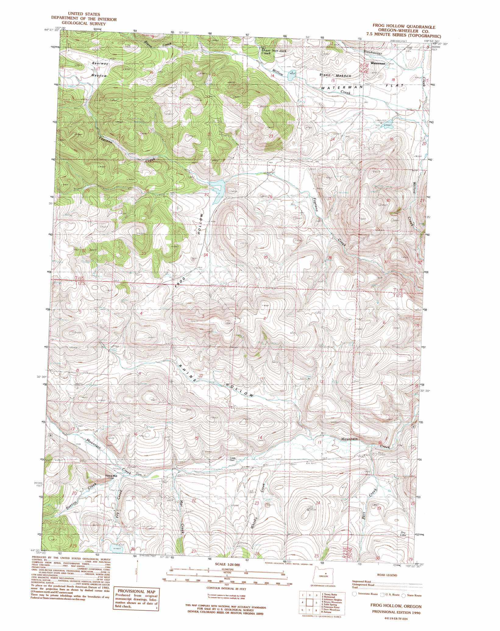
USGS Topo Quad 44119e8 - 1:24,000 scale
| Topo Map Name: | Frog Hollow |
| USGS Topo Quad ID: | 44119e8 |
| Print Size: | ca. 21 1/4" wide x 27" high |
| Southeast Coordinates: | 44.5° N latitude / 119.875° W longitude |
| Map Center Coordinates: | 44.5625° N latitude / 119.9375° W longitude |
| U.S. State: | OR |
| Filename: | o44119e8.jpg |
| Download Map JPG Image: | Frog Hollow topo map 1:24,000 scale |
| Map Type: | Topographic |
| Topo Series: | 7.5´ |
| Map Scale: | 1:24,000 |
| Source of Map Images: | United States Geological Survey (USGS) |
| Alternate Map Versions: |
Frog Hollow OR 1990, updated 1990 Download PDF Buy paper map Frog Hollow OR 2011 Download PDF Buy paper map Frog Hollow OR 2014 Download PDF Buy paper map |
1:24,000 Topo Quads surrounding Frog Hollow
Rowe Creek |
Service Creek |
Massacre Mountain |
Spray |
Kimberly |
Sutton Mountain |
Toney Butte |
Richmond |
Johnson Heights |
Mount Misery |
Mitchell |
Keyes Mountain |
Frog Hollow |
Tubb Spring |
Picture Gorge West |
Mount Pisgah |
Peterson Point |
Derr Meadows |
Antone |
Day Basin |
Williams Prairie |
Keys Creek |
Little Summit Prairie |
Six Corners |
Wolf Mountain |
> Back to 44119e1 at 1:100,000 scale
> Back to 44118a1 at 1:250,000 scale
> Back to U.S. Topo Maps home
Frog Hollow topo map: Gazetteer
Frog Hollow: Airports
Collins Landing Strip elevation 1208m 3963′Frog Hollow: Dams
Blann Meadow Reservoir Dam elevation 1237m 4058′Collins Dam elevation 1239m 4064′
Fopiano Dam elevation 1242m 4074′
Fort Creek Dam elevation 1211m 3973′
Frog Hollow: Flats
Bearway Meadow elevation 1340m 4396′Blann Meadow elevation 1221m 4005′
Waterman Flat elevation 1197m 3927′
Frog Hollow: Lakes
Dry Lake elevation 1217m 3992′Frog Hollow: Populated Places
Caleb (historical) elevation 1173m 3848′Spoos Mill elevation 1203m 3946′
Waterman (historical) elevation 1203m 3946′
Frog Hollow: Post Offices
Caleb Post Office (historical) elevation 1173m 3848′Waterman Post Office (historical) elevation 1203m 3946′
Frog Hollow: Reservoirs
Blann Meadow Reservoir elevation 1237m 4058′Collins Reservoir elevation 1239m 4064′
Fopiano Reservoir elevation 1242m 4074′
Fort Creek Reservoir elevation 1211m 3973′
Frog Hollow: Streams
Blann Creek elevation 1288m 4225′Fort Creek elevation 1153m 3782′
Fry Creek elevation 1201m 3940′
Keeton Creek elevation 1200m 3937′
Mac Creek elevation 1190m 3904′
McKay Creek elevation 1277m 4189′
North Fork Willow Creek elevation 1181m 3874′
Sheet Iron Jack Creek elevation 1255m 4117′
Sixshooter Creek elevation 1189m 3900′
Whisky Creek elevation 1168m 3832′
Frog Hollow: Valleys
Frog Hollow elevation 1250m 4101′Rhine Hollow elevation 1166m 3825′
Frog Hollow digital topo map on disk
Buy this Frog Hollow topo map showing relief, roads, GPS coordinates and other geographical features, as a high-resolution digital map file on DVD: