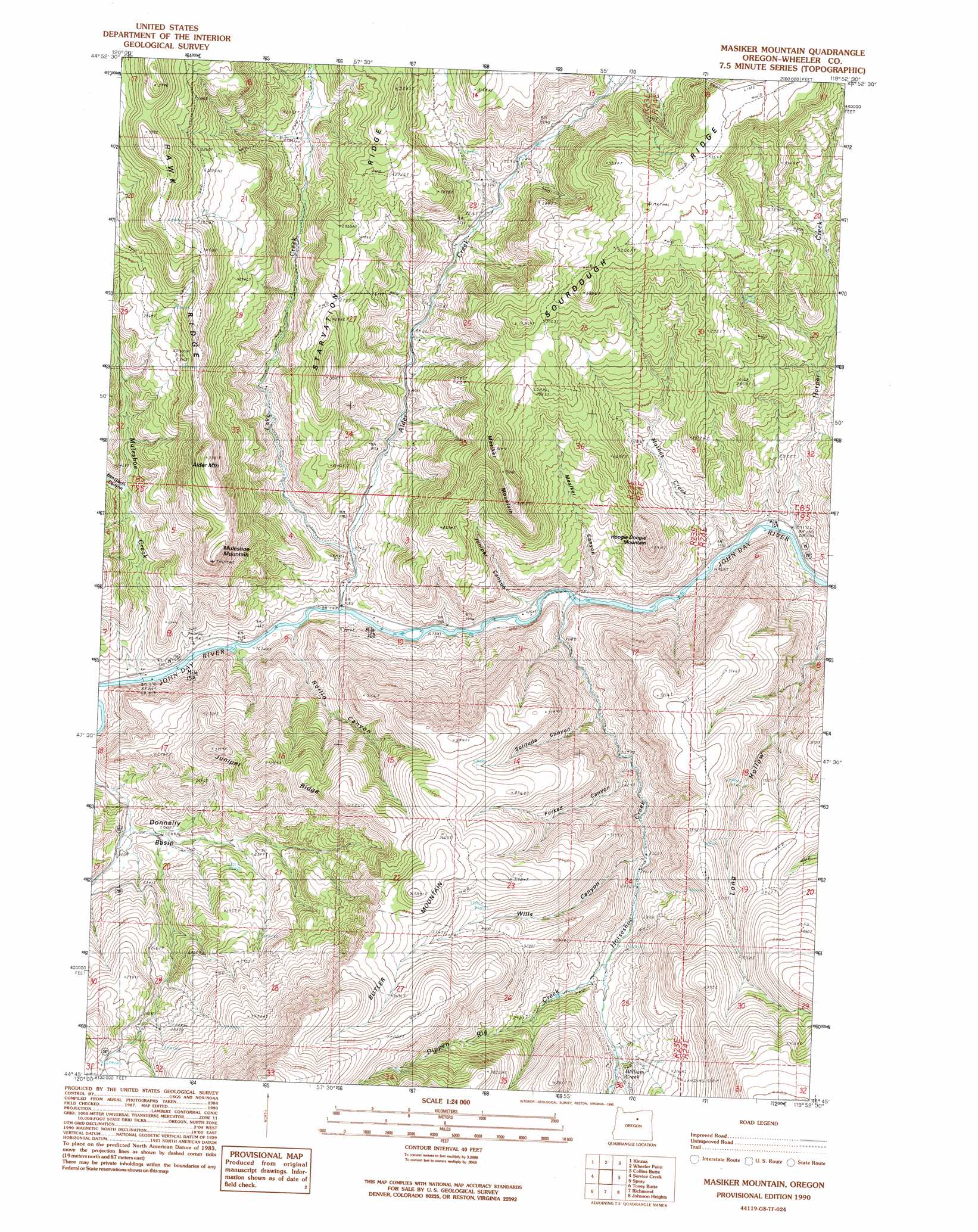
Massacre Mountain Topo Map Oregon
To zoom in, hover over the map of Massacre Mountain
USGS Topo Quad 44119g8 - 1:24,000 scale
| Topo Map Name: | Massacre Mountain |
| USGS Topo Quad ID: | 44119g8 |
| Print Size: | ca. 21 1/4" wide x 27" high |
| Southeast Coordinates: | 44.75° N latitude / 119.875° W longitude |
| Map Center Coordinates: | 44.8125° N latitude / 119.9375° W longitude |
| U.S. State: | OR |
| Filename: | o44119g8.jpg |
| Download Map JPG Image: | Massacre Mountain topo map 1:24,000 scale |
| Map Type: | Topographic |
| Topo Series: | 7.5´ |
| Map Scale: | 1:24,000 |
| Source of Map Images: | United States Geological Survey (USGS) |
| Alternate Map Versions: |
Masiker Mountain OR 1990, updated 1990 Download PDF Buy paper map Masiker Mountain OR 2011 Download PDF Buy paper map Masiker Mountain OR 2014 Download PDF Buy paper map |
1:24,000 Topo Quads surrounding Massacre Mountain
Fossil North |
Salmon Fork |
Lonerock |
Lefevre Prairie |
Chapin Creek |
Fossil South |
Kinzua |
Wheeler Point |
Collins Butte |
Whitetail Butte |
Rowe Creek |
Service Creek |
Massacre Mountain |
Spray |
Kimberly |
Sutton Mountain |
Toney Butte |
Richmond |
Johnson Heights |
Mount Misery |
Mitchell |
Keyes Mountain |
Frog Hollow |
Tubb Spring |
Picture Gorge West |
> Back to 44119e1 at 1:100,000 scale
> Back to 44118a1 at 1:250,000 scale
> Back to U.S. Topo Maps home
Massacre Mountain topo map: Gazetteer
Massacre Mountain: Basins
Donnelly Basin elevation 615m 2017′Massacre Mountain: Ridges
Hawk Ridge elevation 1057m 3467′Juniper Ridge elevation 1090m 3576′
Sourdough Ridge elevation 1011m 3316′
Starvation Ridge elevation 880m 2887′
Massacre Mountain: Springs
Homestead Spring elevation 902m 2959′Rimrock Spring elevation 976m 3202′
Massacre Mountain: Streams
Alder Creek elevation 513m 1683′Dippen Rig Creek elevation 778m 2552′
Donnely Creek elevation 634m 2080′
Grassy Dell Creek elevation 536m 1758′
Harper Creek elevation 524m 1719′
Horseshoe Creek elevation 523m 1715′
Lake Creek elevation 527m 1729′
Mathas Creek elevation 524m 1719′
Muleshoe Creek elevation 513m 1683′
Rock Creek elevation 524m 1719′
William Creek elevation 842m 2762′
Massacre Mountain: Summits
Alder Mountain elevation 1029m 3375′Hoogie Doogie Mountain elevation 850m 2788′
Masiker Mountain elevation 951m 3120′
Muleshoe Mountain elevation 977m 3205′
Massacre Mountain: Valleys
Ben Glenn Canyon elevation 676m 2217′Forked Canyon elevation 647m 2122′
Juniper Canyon elevation 519m 1702′
Masiker Canyon elevation 518m 1699′
Rollin Canyon elevation 510m 1673′
Solitude Canyon elevation 616m 2020′
Wills Canyon elevation 729m 2391′
Massacre Mountain digital topo map on disk
Buy this Massacre Mountain topo map showing relief, roads, GPS coordinates and other geographical features, as a high-resolution digital map file on DVD: