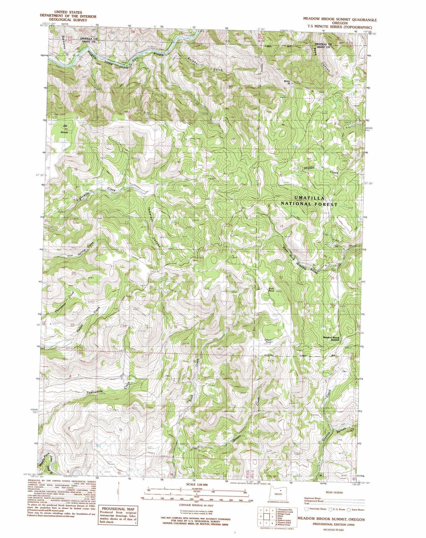
Meadow Brook Summit Topo Map Oregon
To zoom in, hover over the map of Meadow Brook Summit
USGS Topo Quad 44119h1 - 1:24,000 scale
| Topo Map Name: | Meadow Brook Summit |
| USGS Topo Quad ID: | 44119h1 |
| Print Size: | ca. 21 1/4" wide x 27" high |
| Southeast Coordinates: | 44.875° N latitude / 119° W longitude |
| Map Center Coordinates: | 44.9375° N latitude / 119.0625° W longitude |
| U.S. State: | OR |
| Filename: | o44119h1.jpg |
| Download Map JPG Image: | Meadow Brook Summit topo map 1:24,000 scale |
| Map Type: | Topographic |
| Topo Series: | 7.5´ |
| Map Scale: | 1:24,000 |
| Source of Map Images: | United States Geological Survey (USGS) |
| Alternate Map Versions: |
Meadow Brook Summit OR 1990, updated 1990 Download PDF Buy paper map Meadow Brook Summit OR 1995, updated 1998 Download PDF Buy paper map Meadow Brook Summit OR 2011 Download PDF Buy paper map Meadow Brook Summit OR 2014 Download PDF Buy paper map |
| FStopo: | US Forest Service topo Meadow Brook Summit is available: Download FStopo PDF Download FStopo TIF |
1:24,000 Topo Quads surrounding Meadow Brook Summit
Arbuckle Mountain |
Matlock Prairie |
Sugarbowl Creek |
Ukiah |
Owens Butte |
Lake Penland |
Thompson Flat |
Deerhorn Creek |
Bridge Creek |
Ukiah Se |
Slickear Mountain |
Ritter |
Meadow Brook Summit |
Dale |
The Cockscomb |
Steet Mountain |
Bullock Gulch |
Flowers Gulch |
Wildcat Point |
Sharp Ridge |
Hamilton |
Fox |
Long Creek |
Keeney Point |
Susanville |
> Back to 44119e1 at 1:100,000 scale
> Back to 44118a1 at 1:250,000 scale
> Back to U.S. Topo Maps home
Meadow Brook Summit topo map: Gazetteer
Meadow Brook Summit: Capes
Bone Point elevation 1363m 4471′Meadow Brook Summit: Flats
Elk Grove elevation 1389m 4557′Litch Meadow elevation 1317m 4320′
Meadow Brook Summit: Gaps
Meadow Brook Summit elevation 1258m 4127′Meadow Brook Summit: Lakes
Gilson Pond elevation 1398m 4586′Rush Pond elevation 1435m 4708′
Meadow Brook Summit: Streams
Barnes Creek elevation 1098m 3602′Buckaroo Creek elevation 768m 2519′
Gilson Creek elevation 939m 3080′
Meadow Brook Summit: Valleys
Sulphur Gulch elevation 785m 2575′Tamarack Canyon elevation 1162m 3812′
Meadow Brook Summit digital topo map on disk
Buy this Meadow Brook Summit topo map showing relief, roads, GPS coordinates and other geographical features, as a high-resolution digital map file on DVD: