Slickear Mountain Topo Map Oregon
To zoom in, hover over the map of Slickear Mountain
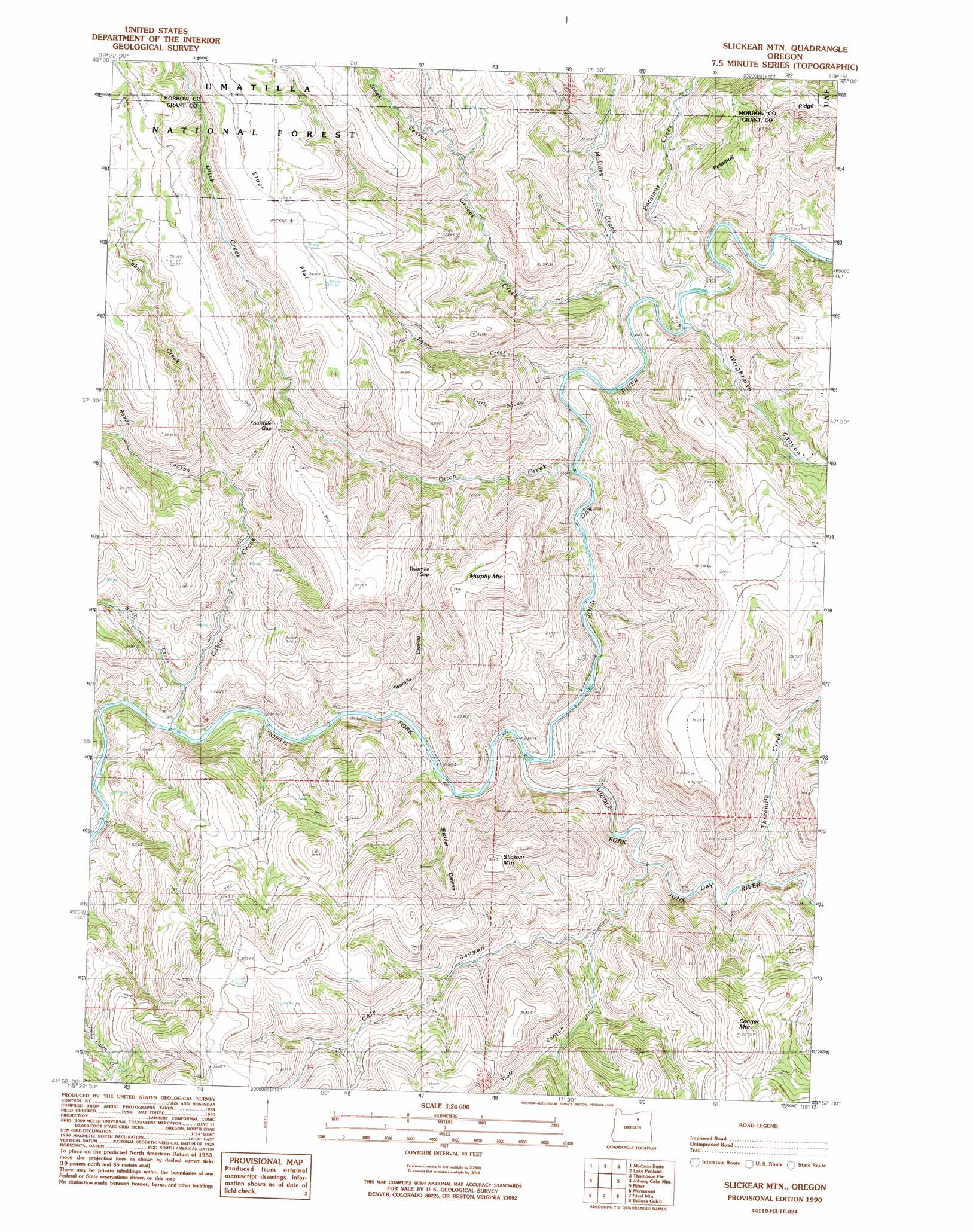
USGS Topo Quad 44119h3 - 1:24,000 scale
| Topo Map Name: | Slickear Mountain |
| USGS Topo Quad ID: | 44119h3 |
| Print Size: | ca. 21 1/4" wide x 27" high |
| Southeast Coordinates: | 44.875° N latitude / 119.25° W longitude |
| Map Center Coordinates: | 44.9375° N latitude / 119.3125° W longitude |
| U.S. State: | OR |
| Filename: | o44119h3.jpg |
| Download Map JPG Image: | Slickear Mountain topo map 1:24,000 scale |
| Map Type: | Topographic |
| Topo Series: | 7.5´ |
| Map Scale: | 1:24,000 |
| Source of Map Images: | United States Geological Survey (USGS) |
| Alternate Map Versions: |
Slickear Mtn OR 1990, updated 1990 Download PDF Buy paper map Slickear Mountain OR 1995, updated 1998 Download PDF Buy paper map Slickear Mountain OR 2011 Download PDF Buy paper map Slickear Mountain OR 2014 Download PDF Buy paper map |
| FStopo: | US Forest Service topo Slickear Mountain is available: Download FStopo PDF Download FStopo TIF |
1:24,000 Topo Quads surrounding Slickear Mountain
Balm Canyon |
Summerfield Ridge |
Arbuckle Mountain |
Matlock Prairie |
Sugarbowl Creek |
Big Rock Flat |
Madison Butte |
Lake Penland |
Thompson Flat |
Deerhorn Creek |
Turner Mountain |
Johnny Cake Mountain |
Slickear Mountain |
Ritter |
Meadow Brook Summit |
Bologna Basin |
Monument |
Steet Mountain |
Bullock Gulch |
Flowers Gulch |
Miller Flat |
Courthouse Rock |
Hamilton |
Fox |
Long Creek |
> Back to 44119e1 at 1:100,000 scale
> Back to 44118a1 at 1:250,000 scale
> Back to U.S. Topo Maps home
Slickear Mountain topo map: Gazetteer
Slickear Mountain: Flats
Elder Flat elevation 1087m 3566′Slickear Mountain: Gaps
Fourmile Gap elevation 944m 3097′Twomile Gap elevation 942m 3090′
Slickear Mountain: Ridges
Potamus Ridge elevation 1031m 3382′Slickear Mountain: Streams
Birch Creek elevation 687m 2253′Cabin Creek elevation 649m 2129′
Ditch Creek elevation 685m 2247′
Graves Creek elevation 705m 2312′
Little Squaw Creek elevation 709m 2326′
Mallory Creek elevation 696m 2283′
Middle Fork John Day River elevation 668m 2191′
Potamus Creek elevation 705m 2312′
Squaw Creek elevation 686m 2250′
Threemile Creek elevation 698m 2290′
Slickear Mountain: Summits
Conger Mountain elevation 1083m 3553′Murphy Mountain elevation 1069m 3507′
Slickear Mountain elevation 1098m 3602′
Slickear Mountain: Valleys
Cole Canyon elevation 690m 2263′Jones Canyon elevation 876m 2874′
Reade Canyon elevation 826m 2709′
Slickear Canyon elevation 660m 2165′
Troff Canyon elevation 742m 2434′
Twomile Canyon elevation 659m 2162′
Wrightman Canyon elevation 701m 2299′
Slickear Mountain digital topo map on disk
Buy this Slickear Mountain topo map showing relief, roads, GPS coordinates and other geographical features, as a high-resolution digital map file on DVD: