Rabbit Valley Topo Map Oregon
To zoom in, hover over the map of Rabbit Valley
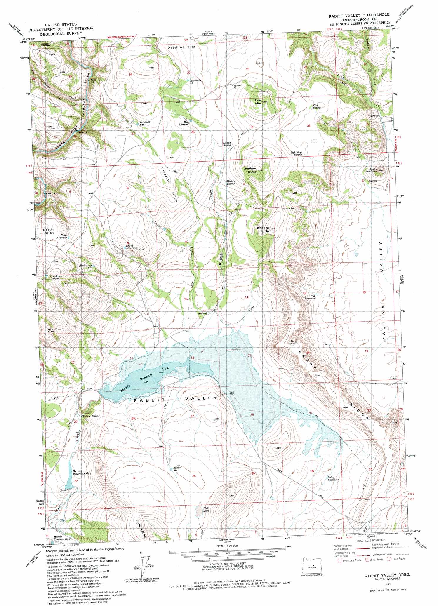
USGS Topo Quad 44120b1 - 1:24,000 scale
| Topo Map Name: | Rabbit Valley |
| USGS Topo Quad ID: | 44120b1 |
| Print Size: | ca. 21 1/4" wide x 27" high |
| Southeast Coordinates: | 44.125° N latitude / 120° W longitude |
| Map Center Coordinates: | 44.1875° N latitude / 120.0625° W longitude |
| U.S. State: | OR |
| Filename: | o44120b1.jpg |
| Download Map JPG Image: | Rabbit Valley topo map 1:24,000 scale |
| Map Type: | Topographic |
| Topo Series: | 7.5´ |
| Map Scale: | 1:24,000 |
| Source of Map Images: | United States Geological Survey (USGS) |
| Alternate Map Versions: |
Rabbit Valley OR 1982, updated 1983 Download PDF Buy paper map Rabbit Valley OR 1992, updated 1997 Download PDF Buy paper map Rabbit Valley OR 2011 Download PDF Buy paper map Rabbit Valley OR 2014 Download PDF Buy paper map |
| FStopo: | US Forest Service topo Rabbit Valley is available: Download FStopo PDF Download FStopo TIF |
1:24,000 Topo Quads surrounding Rabbit Valley
Ochoco Butte |
Mount Pisgah |
Peterson Point |
Derr Meadows |
Antone |
Lookout Mountain |
Williams Prairie |
Keys Creek |
Little Summit Prairie |
Six Corners |
Prairie Hill |
Committee Creek |
Rabbit Valley |
Paulina |
Mud Spring |
Drake Butte |
Arrowwood Point |
Liggett Table |
Maupin Butte |
Angell Butte |
Logan Butte |
Gerry Mountain |
Sand Hollow |
Hardin Ranch |
Twelvemile Reservoir |
> Back to 44120a1 at 1:100,000 scale
> Back to 44120a1 at 1:250,000 scale
> Back to U.S. Topo Maps home
Rabbit Valley topo map: Gazetteer
Rabbit Valley: Basins
Rabbit Valley elevation 1190m 3904′Rabbit Valley: Dams
Gale-Merwin Dam elevation 1116m 3661′Merwin Dam Number 1 elevation 1091m 3579′
Merwin Dam Number 2 elevation 1118m 3667′
Merwin Dam Number 3 elevation 1165m 3822′
Watson Dam elevation 1169m 3835′
Rabbit Valley: Flats
Deadline Flat elevation 1320m 4330′Flat Lake elevation 1217m 3992′
Rabbit Valley: Reservoirs
Biddle Reservoir elevation 1219m 3999′Bone Reservoir elevation 1313m 4307′
Clover Creek Reservoir elevation 1250m 4101′
Foster Reservoir elevation 1261m 4137′
Jumbuck Reservoir elevation 1316m 4317′
Little Basin Reservoir elevation 1363m 4471′
Merwin Reservoir Number 2 elevation 1118m 3667′
Merwin Reservoir Number 3 elevation 1165m 3822′
Owl Reservoir elevation 1169m 3835′
Poley Reservoir elevation 1168m 3832′
Reservoir Twenty-eight elevation 1320m 4330′
Sheep Reservoir elevation 1271m 4169′
Sheepcamp Reservoir elevation 1290m 4232′
Watson Reservoir elevation 1159m 3802′
Rabbit Valley: Ridges
Lakeside Ridge elevation 1315m 4314′Sabre Ridge elevation 1284m 4212′
Rabbit Valley: Springs
Lightning Spring elevation 1307m 4288′Llewelyn Spring elevation 1284m 4212′
Lower Watson Spring elevation 1140m 3740′
Pine Spring elevation 1307m 4288′
Watson Spring elevation 1286m 4219′
Rabbit Valley: Streams
Clover Creek elevation 1170m 3838′Fox Canyon Creek elevation 1238m 4061′
Indian Creek elevation 1176m 3858′
Roba Creek elevation 1173m 3848′
Rabbit Valley: Summits
Isadore Butte elevation 1329m 4360′Juniper Butte elevation 1380m 4527′
Pine Mountain elevation 1372m 4501′
York Butte elevation 1326m 4350′
Rabbit Valley digital topo map on disk
Buy this Rabbit Valley topo map showing relief, roads, GPS coordinates and other geographical features, as a high-resolution digital map file on DVD: