Prairie Hill Topo Map Oregon
To zoom in, hover over the map of Prairie Hill
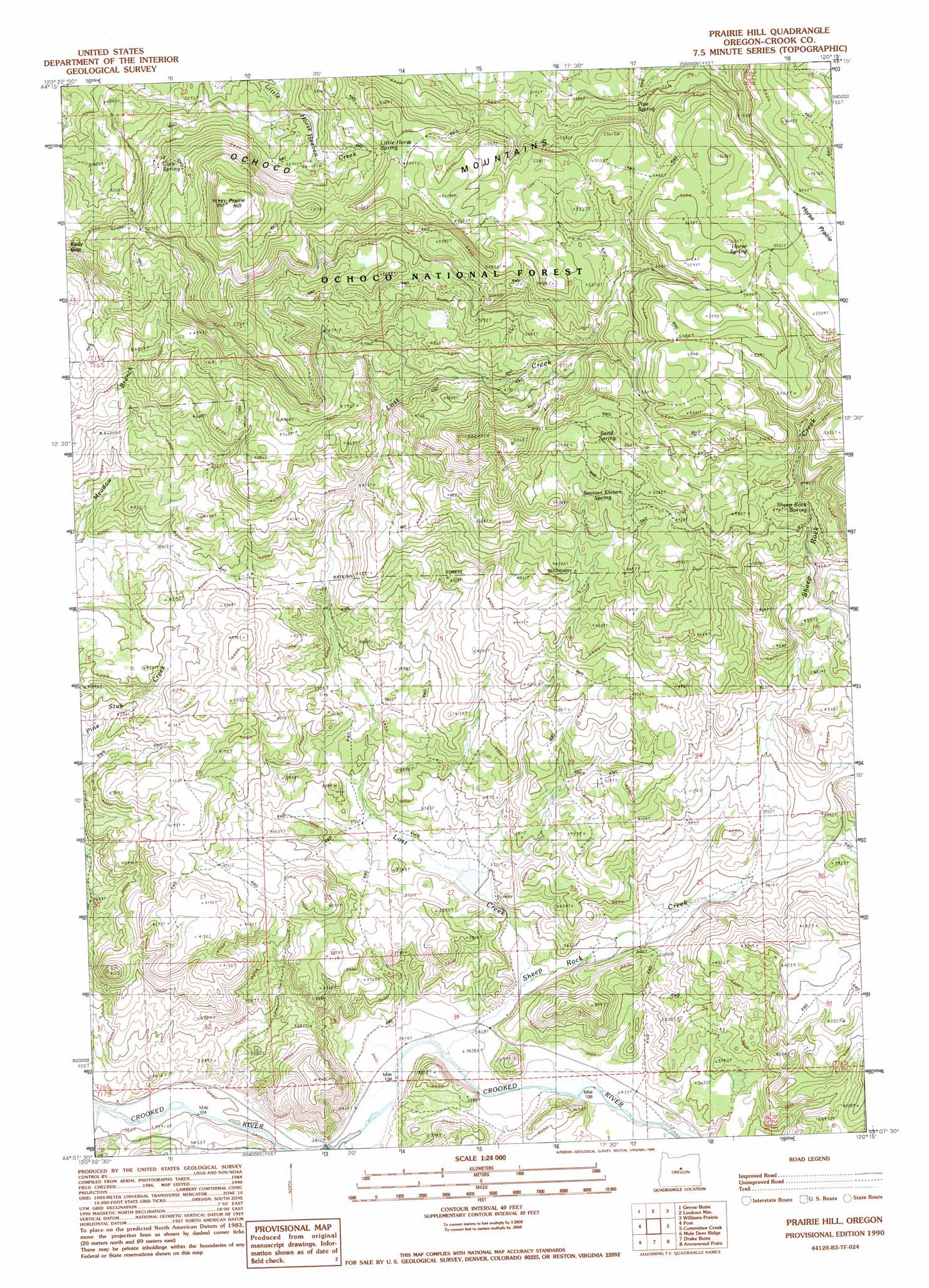
USGS Topo Quad 44120b3 - 1:24,000 scale
| Topo Map Name: | Prairie Hill |
| USGS Topo Quad ID: | 44120b3 |
| Print Size: | ca. 21 1/4" wide x 27" high |
| Southeast Coordinates: | 44.125° N latitude / 120.25° W longitude |
| Map Center Coordinates: | 44.1875° N latitude / 120.3125° W longitude |
| U.S. State: | OR |
| Filename: | o44120b3.jpg |
| Download Map JPG Image: | Prairie Hill topo map 1:24,000 scale |
| Map Type: | Topographic |
| Topo Series: | 7.5´ |
| Map Scale: | 1:24,000 |
| Source of Map Images: | United States Geological Survey (USGS) |
| Alternate Map Versions: |
Prairie Hill OR 1990, updated 1990 Download PDF Buy paper map Prairie Hill OR 1992, updated 1997 Download PDF Buy paper map Prairie Hill OR 2011 Download PDF Buy paper map Prairie Hill OR 2014 Download PDF Buy paper map |
| FStopo: | US Forest Service topo Prairie Hill is available: Download FStopo PDF Download FStopo TIF |
1:24,000 Topo Quads surrounding Prairie Hill
Wildcat Mountain |
Whistler Point |
Ochoco Butte |
Mount Pisgah |
Peterson Point |
Cadle Butte |
Gerow Butte |
Lookout Mountain |
Williams Prairie |
Keys Creek |
Pilot Butte |
Post |
Prairie Hill |
Committee Creek |
Rabbit Valley |
Conant Basin |
Mule Deer Ridge |
Drake Butte |
Arrowwood Point |
Liggett Table |
Sugarloaf Butte |
Pringle Flat |
Logan Butte |
Gerry Mountain |
Sand Hollow |
> Back to 44120a1 at 1:100,000 scale
> Back to 44120a1 at 1:250,000 scale
> Back to U.S. Topo Maps home
Prairie Hill topo map: Gazetteer
Prairie Hill: Dams
Dick Dam elevation 1099m 3605′Prairie Hill: Flats
Horse Prairie elevation 1672m 5485′Prairie Hill: Reservoirs
Dick Reservoir elevation 1099m 3605′Sheep Rock Reservoir elevation 1650m 5413′
Township Reservoir elevation 1187m 3894′
Prairie Hill: Springs
Coin Spring elevation 1534m 5032′Coyote Spring elevation 1613m 5291′
Gibson Spring elevation 1283m 4209′
Horse Spring elevation 1695m 5561′
Little Horse Spring elevation 1650m 5413′
Pipe Spring elevation 1577m 5173′
Sand Spring elevation 1547m 5075′
Section 11 Spring elevation 1468m 4816′
Sheep Rock Spring elevation 1498m 4914′
Wasp Spring elevation 1672m 5485′
Prairie Hill: Streams
Keeney Creek elevation 1047m 3435′Lost Creek elevation 1062m 3484′
Sheep Rock Creek elevation 1061m 3480′
Spring Creek elevation 1094m 3589′
Prairie Hill: Summits
Prairie Hill elevation 1759m 5770′Prairie Hill digital topo map on disk
Buy this Prairie Hill topo map showing relief, roads, GPS coordinates and other geographical features, as a high-resolution digital map file on DVD: