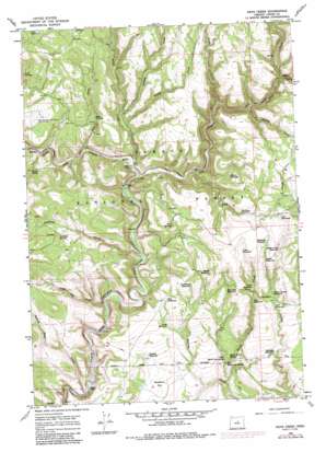
Keys Creek Topo Map Oregon
To zoom in, hover over the map of Keys Creek
USGS Topo Quad 44120c1 - 1:24,000 scale
| Topo Map Name: | Keys Creek |
| USGS Topo Quad ID: | 44120c1 |
| Print Size: | ca. 21 1/4" wide x 27" high |
| Southeast Coordinates: | 44.25° N latitude / 120° W longitude |
| Map Center Coordinates: | 44.3125° N latitude / 120.0625° W longitude |
| U.S. State: | OR |
| Filename: | o44120c1.jpg |
| Download Map JPG Image: | Keys Creek topo map 1:24,000 scale |
| Map Type: | Topographic |
| Topo Series: | 7.5´ |
| Map Scale: | 1:24,000 |
| Source of Map Images: | United States Geological Survey (USGS) |
| Alternate Map Versions: |
Keys Creek OR 1966, updated 1968 Download PDF Buy paper map Keys Creek OR 1966, updated 1985 Download PDF Buy paper map Keys Creek OR 1992, updated 1997 Download PDF Buy paper map Keys Creek OR 2011 Download PDF Buy paper map Keys Creek OR 2014 Download PDF Buy paper map |
| FStopo: | US Forest Service topo Keys Creek is available: Download FStopo PDF Download FStopo TIF |
1:24,000 Topo Quads surrounding Keys Creek
> Back to 44120a1 at 1:100,000 scale
> Back to 44120a1 at 1:250,000 scale
> Back to U.S. Topo Maps home
Keys Creek topo map: Gazetteer
Keys Creek: Falls
Upper Falls elevation 1258m 4127′Keys Creek: Reservoirs
Amber Reservoir elevation 1443m 4734′Bentonite Reservoir elevation 1459m 4786′
Cary Reservoir elevation 1495m 4904′
Charity Reservoir elevation 1395m 4576′
Cinch Reservoir elevation 1441m 4727′
Connell Reservoir elevation 1415m 4642′
Cross Reservoir elevation 1453m 4767′
Crossroads Reservoir elevation 1400m 4593′
Doe Reservoir elevation 1375m 4511′
Dry Reservoir elevation 1470m 4822′
Fawn Reservoir elevation 1395m 4576′
Flat Reservoir elevation 1382m 4534′
Horseshoe Reservoir elevation 1384m 4540′
Indian Creek Reservoir elevation 1451m 4760′
Indian Spring Reservoir elevation 1391m 4563′
Jade Reservoir elevation 1374m 4507′
Marble Reservoir elevation 1424m 4671′
Paulina Reservoir elevation 1338m 4389′
Pine Reservoir elevation 1425m 4675′
Roadside Reservoir elevation 1337m 4386′
Shale Reservoir elevation 1463m 4799′
Tansy Reservoir elevation 1358m 4455′
Twin Springs Reservoir elevation 1415m 4642′
Keys Creek: Springs
Burnt Corral Spring elevation 1297m 4255′Butler Spring elevation 1386m 4547′
Donnelly Spring elevation 1425m 4675′
East Burnt Log Spring elevation 1291m 4235′
Fir Tree Spring elevation 1396m 4580′
Keys Troughs elevation 1418m 4652′
Market Spring elevation 1426m 4678′
Sand Spring elevation 1332m 4370′
Shown Troughs elevation 1462m 4796′
Twin Springs elevation 1432m 4698′
West Burnt Log Spring elevation 1293m 4242′
Keys Creek: Streams
Big Spring Creek elevation 1403m 4603′Buck Hollow Creek elevation 1336m 4383′
Burnt Corral Creek elevation 1251m 4104′
Crazy Creek elevation 1390m 4560′
Deep Creek elevation 1323m 4340′
Donnelly Creek elevation 1304m 4278′
Indian Trail Creek elevation 1250m 4101′
Keys Creek elevation 1333m 4373′
Lame Dog Creek elevation 1279m 4196′
Little Summit Creek elevation 1441m 4727′
Looney Creek elevation 1390m 4560′
Porter Creek elevation 1329m 4360′
Stupid Creek elevation 1393m 4570′
Keys Creek digital topo map on disk
Buy this Keys Creek topo map showing relief, roads, GPS coordinates and other geographical features, as a high-resolution digital map file on DVD:


