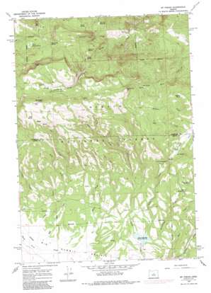
Mount Pisgah Topo Map Oregon
To zoom in, hover over the map of Mount Pisgah
USGS Topo Quad 44120d2 - 1:24,000 scale
| Topo Map Name: | Mount Pisgah |
| USGS Topo Quad ID: | 44120d2 |
| Print Size: | ca. 21 1/4" wide x 27" high |
| Southeast Coordinates: | 44.375° N latitude / 120.125° W longitude |
| Map Center Coordinates: | 44.4375° N latitude / 120.1875° W longitude |
| U.S. State: | OR |
| Filename: | o44120d2.jpg |
| Download Map JPG Image: | Mount Pisgah topo map 1:24,000 scale |
| Map Type: | Topographic |
| Topo Series: | 7.5´ |
| Map Scale: | 1:24,000 |
| Source of Map Images: | United States Geological Survey (USGS) |
| Alternate Map Versions: |
Mt. Pisgah OR 1966, updated 1968 Download PDF Buy paper map Mt. Pisgah OR 1966, updated 1985 Download PDF Buy paper map Mt. Pisgah OR 1992, updated 1997 Download PDF Buy paper map Mount Pisgah OR 2011 Download PDF Buy paper map Mount Pisgah OR 2014 Download PDF Buy paper map |
| FStopo: | US Forest Service topo Mount Pisgah is available: Download FStopo PDF Download FStopo TIF |
1:24,000 Topo Quads surrounding Mount Pisgah
> Back to 44120a1 at 1:100,000 scale
> Back to 44120a1 at 1:250,000 scale
> Back to U.S. Topo Maps home
Mount Pisgah topo map: Gazetteer
Mount Pisgah: Cliffs
North Point elevation 1943m 6374′Mount Pisgah: Dams
Allen Creek Dam elevation 1442m 4730′Mount Pisgah: Reservoirs
Allen Creek Reservoir elevation 1439m 4721′Maxwell Reservoir elevation 1590m 5216′
Ross Reservoir elevation 1551m 5088′
Yellowjacket Reservoir elevation 1579m 5180′
Mount Pisgah: Springs
Bridge Spring elevation 1732m 5682′Dent Spring elevation 1592m 5223′
Hemp Spring elevation 1545m 5068′
Hoffman Spring elevation 1620m 5314′
Masterson Spring elevation 1726m 5662′
Maxwell Spring elevation 1713m 5620′
Milk Spring elevation 1807m 5928′
Mud Spring elevation 1567m 5141′
Nelson Spring elevation 1682m 5518′
North Pisgah Spring elevation 1671m 5482′
Pisgah Spring elevation 1902m 6240′
Slow Spring elevation 1554m 5098′
Wolf Spring elevation 1976m 6482′
Mount Pisgah: Streams
Beetle Creek elevation 1439m 4721′Bug Creek elevation 1537m 5042′
Crosswhite Creek elevation 1407m 4616′
East Fork Elliot Creek elevation 1427m 4681′
Fox Creek elevation 1377m 4517′
Maxwell Creek elevation 1387m 4550′
Shady Creek elevation 1378m 4520′
Stump Creek elevation 1379m 4524′
West Fork Fox Creek elevation 1494m 4901′
Yellowjacket Creek elevation 1440m 4724′
Mount Pisgah: Summits
East Point elevation 2013m 6604′Mount Pisgah elevation 2076m 6811′
Mount Pisgah digital topo map on disk
Buy this Mount Pisgah topo map showing relief, roads, GPS coordinates and other geographical features, as a high-resolution digital map file on DVD:


