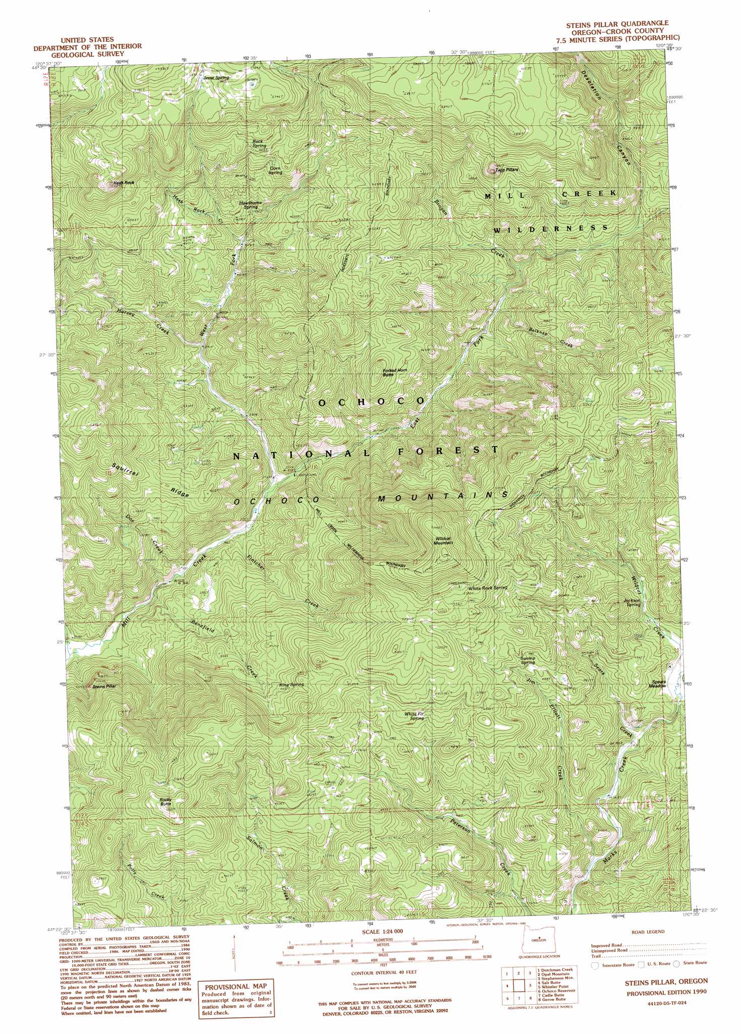
Wildcat Mountain Topo Map Oregon
To zoom in, hover over the map of Wildcat Mountain
USGS Topo Quad 44120d5 - 1:24,000 scale
| Topo Map Name: | Wildcat Mountain |
| USGS Topo Quad ID: | 44120d5 |
| Print Size: | ca. 21 1/4" wide x 27" high |
| Southeast Coordinates: | 44.375° N latitude / 120.5° W longitude |
| Map Center Coordinates: | 44.4375° N latitude / 120.5625° W longitude |
| U.S. State: | OR |
| Filename: | o44120d5.jpg |
| Download Map JPG Image: | Wildcat Mountain topo map 1:24,000 scale |
| Map Type: | Topographic |
| Topo Series: | 7.5´ |
| Map Scale: | 1:24,000 |
| Source of Map Images: | United States Geological Survey (USGS) |
| Alternate Map Versions: |
Steins Pillar OR 1990, updated 1990 Download PDF Buy paper map Steins Pillar OR 1992, updated 1997 Download PDF Buy paper map Steins Pillar OR 2011 Download PDF Buy paper map Steins Pillar OR 2014 Download PDF Buy paper map |
| FStopo: | US Forest Service topo Steins Pillar is available: Download FStopo PDF Download FStopo TIF |
1:24,000 Topo Quads surrounding Wildcat Mountain
Ashwood |
Axehandle Butte |
Horse Heaven Creek |
Sandrock Mountain |
Painted Hills |
Foley Butte |
Dutchman Creek |
Opal Mountain |
Stephenson Mountain |
Lawson Mountain |
Hensley Butte |
Salt Butte |
Wildcat Mountain |
Whistler Point |
Ochoco Butte |
Prineville |
Ochoco Reservoir |
Cadle Butte |
Gerow Butte |
Lookout Mountain |
Stearns Butte |
Eagle Rock |
Pilot Butte |
Post |
Prairie Hill |
> Back to 44120a1 at 1:100,000 scale
> Back to 44120a1 at 1:250,000 scale
> Back to U.S. Topo Maps home
Wildcat Mountain topo map: Gazetteer
Wildcat Mountain: Pillars
Steins Pillar elevation 1260m 4133′Twin Pillars elevation 1684m 5524′
Wildcat Mountain: Post Offices
Barney Post Office (historical) elevation 1094m 3589′Wildcat Mountain: Ridges
Squirrel Ridge elevation 1394m 4573′Wildcat Mountain: Springs
Dorn Spring elevation 1528m 5013′Hawthorne Spring elevation 1321m 4333′
Jackson Spring elevation 1260m 4133′
Jesse Spring elevation 1696m 5564′
King Spring elevation 1424m 4671′
Rock Spring elevation 1541m 5055′
Swamp Spring elevation 1403m 4603′
White Fir Spring elevation 1482m 4862′
White Rock Spring elevation 1632m 5354′
Wildcat Mountain: Streams
Belknap Creek elevation 1230m 4035′Benefield Creek elevation 1103m 3618′
Brogan Creek elevation 1256m 4120′
Doe Creek elevation 1109m 3638′
East Fork Mill Creek elevation 1136m 3727′
Fintcher Creek elevation 1121m 3677′
Harvey Creek elevation 1200m 3937′
Hash Rock Creek elevation 1266m 4153′
Jim Elliott Creek elevation 1147m 3763′
Lemon Creek elevation 1098m 3602′
Riley Creek elevation 1165m 3822′
Sears Creek elevation 1179m 3868′
West Fork Mill Creek elevation 1136m 3727′
Wildcat Mountain: Summits
Forked Horn Butte elevation 1493m 4898′Hash Rock elevation 1754m 5754′
Rocky Butte elevation 1630m 5347′
Wildcat Mountain elevation 1828m 5997′
Wildcat Mountain: Valleys
Desolation Canyon elevation 1329m 4360′Wildcat Mountain digital topo map on disk
Buy this Wildcat Mountain topo map showing relief, roads, GPS coordinates and other geographical features, as a high-resolution digital map file on DVD: